5:31 PM Wednesday, September 28, 2022
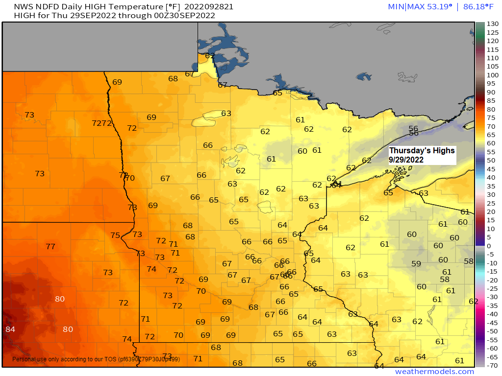
Milder temperatures will return to the Northland the next few days with afternoon temperatures mainly in the 60s to around 70 Thursday through Sunday, but winds will become easterly near Lake Superior Saturday and Sunday which will keep temperatures on the cool side compared to inland locations.
A widespread freeze occurred in the Northland this morning, Wednesday, September 28, 2022. As a result of this, the National Weather Service in Duluth will not be issuing any more frost or freeze headlines for the rest of fall 2022.
Low Temperature reports from Wednesday morning, September 28, 2022
Source: NWS Duluth, MN
2 S Brimson, MN: 21 F
Embarrass, MN: 23 F
Eveleth, MN: 23 F
Seagull Lake, MN: 23 F
Chisholm-Hibbing, MN (Airport) 24 F
Glidden, WI: 24 F
Minong, WI: 24 F
Barnes, WI: 25 F
Cook, MN: 25 F
Ely, MN: 25 F
Eveleth-Virginia, MN (Airport) 25 F
Grand Marais, MN (Airport) 25 F
Aitkin, MN: 25 F
Hill City, MN: 25 F
Solon Springs, WI: 25 F
Hayward, WI: 25 F
Superior, WI (Airport) 26 F
Isabella, MN: 26 F
Siren, WI: 26 F
Ashland, WI: 27 F
Bigfork, MN: 27 F
International Falls, MN: 27 F
Orr, MN: 27 F
Hermantown, MN: 27 F
Spooner, WI: 27 F
Webb Lake, WI: 28 F
Saginaw, MN: 28 F
Grand Rapids, MN: 28 F
Northome, MN: 28 F
McGregor, MN: 28 F
Cloquet, MN: 28 F
Pine River, MN: 28 F
Cass Lake, MN: 28 F
Shell Lake, WI: 29 F
Winter, WI: 29 F
Hurley, WI: 29 F
Cable, WI: 29 F
Duluth, MN (Airport) 29 F
Brainerd, MN: 29 F
Littlefork, MN: 29 F
Winton, MN: 29 F
Washburn, WI: 30 F
Hinckley, MN: 30 F
Moose Lake, MN: 30 F
Esko, MN: 30 F
Deer River, MN: 31 F
Duluth Sky Harbor Airport: 34 F
Larsmont, MN: 35 F
Bay of Grand Marais, MN: 36 F
Note: Low of 29 at the Duluth Airport this morning (9/28/2022). Last time Duluth had a sub-freezing temperature was on May 4, 2022 (low of 30)
*First 32 degree or lower temperature last year in Duluth occurred on October 21. So, this year’s first 32 degree or lower temperature occurred much earlier compared to last year, but also occurred very close to the mean date of September 30 for the first 32 degree or lower temperature.
Low temperatures in the Northland Wednesday morning were well below normal for September 28th, but not cold enough to set new low temperature records for the date – See below
Ashland, WI: 12 set in 1893
Brainerd, MN: 19 set in 1942
Hibbing, MN: 20 set in 1967
International Falls, MN: 24 set in 1907
Duluth, MN: 24 set in 1961
No major systems will be impacting the Northland through this weekend, but a combination of a few things, including warm air advection, a low-level jet, and a frontal boundary moving south across the area may be enough to trigger a few rain showers at times beginning on Thursday and continuing through the day on Friday.
Here’s the 18z NAM 3km model radar forecast valid from 7 AM Thursday to 7 AM Friday.

There are some major differences with rainfall totals in our area through Friday, with the European model considerably wetter compared to other models.
Euro model is forecasting 1″+ rain totals in Duluth by 7 PM Friday.

HREF model is completely dry for Duluth with only a few pockets of 0.01″ rain totals in our area (light green colored areas)

HURRICANE IAN UPDATE
5 PM ET, Wednesday, September 28, 2022
Source: National Hurricane Center
Location: About 5 miles east of Punta Gorda, Florida. About 120 miles south-southwest of Orlando, Florida.
Maximum sustained winds: 140 mph (category 4 hurricane)
Present movement: north/northeast at 8 mph
Minimum central pressure: 945 mb/27.91 inches
*The center of Ian is expected to move across central Florida tonight and Thursday morning and emerge over the western Atlantic by late Thursday. Ian is forecast to turn north on Friday and approach the northeast Florida coast, Georgia and South Carolina coasts late Friday.
*Hurricane force winds extend outward up to 50 miles from the center and tropical-storm force winds extend outward up to 175 miles.
Forecast track of Ian.
T=Tropical Storm
Note: Ian weakens to a tropical storm on Friday as it crosses central Florida, but there is a chance that Ian will become a hurricane once again as it moves over the western Atlantic (pink outlined area) before making landfall somewhere in southern South Carolina Friday afternoon.

Peak Storm Surge Forecast

Ian Rainfall Forecast – Parts of central and northeast Florida could see 10-20″+ of rain.

Goes-16 satellite loops of Hurricane Ian (loop times end 5:37 PM ET, Wednesday, September 28, 2022)
Infrared imagery

Visible imagery

True color imagery

Thanks for reading!
Tim
Leave a Reply