5:43 PM Thursday, October 6, 2022
A very dry weather pattern is expected to continue across the Northland for the next two weeks with any precipitation that we do get remaining on the light side whether it’s in the form of rain or snow.
A cool Friday will give way to milder temperatures this weekend. Highs in the 40s Friday, and in the 50s to around 60 for Saturday and Sunday, and these milder temperatures are expected to stick around into early next week.
Precipitation anomaly forecast through October 21, 2022.

Scattered rain showers will continue across the Northland this evening which will likely mix with and change to snow showers and flurries in parts of the area later tonight into Friday morning as temperatures near the surface continue to fall.
The South Shore of Lake Superior in northwest Wisconsin will continue to get some lake effect precipitation into Friday morning with a favorable setup in place to support lake effect precipitation, and we may even see some lake effect precipitation develop off some of the inland lakes in northern Minnesota tonight.
18z NAM 3km model radar forecast through 4 PM Friday.
Rain – Green
Snow – Blue

Drought continues to expand and worsen across Minnesota and Wisconsin.
Drought monitor for October 4, 2022
Minnesota
3% of the state is in Extreme Drought, up from 0% last week.
11% of the state is in Severe Drought, up from 4% last week.
34% of the state is in Moderate Drought, up from 22% last week.
77% of the state is Abnormally Dry, up from 54% last week.

Wisconsin
3% of the state is in Severe Drought, unchanged from last week.
12% of the state is in Moderate Drought, up from 11% last week.
53% of the state is Abnormally Dry, up from 35% last week.

Here’s the 4-week Drought Monitor Class Change for the Northland — October 4, 2022, compared to September 6, 2022.
Orange colors – 1 to 2 Class Degradation
Gray – No Change

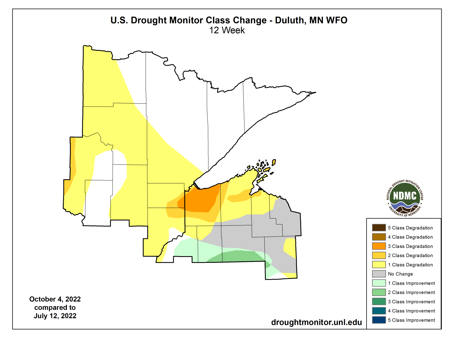
And here’s the 12-week Drought Monitor Class Change for the Northland — October 4, 2022, compared to July 12, 2022.
Western and southern portions of the Northland continue to see worsening drought conditions, particularly along the South Shore of Lake Superior in northwest Wisconsin extending west into a small part of far eastern Minnesota between Duluth and Bruno.

Percent of Normal Precipitation for the last 90 days — July 8, 2022, to October 5, 2022.
Red – Dry to Very Dry
Green, blue and purple – Wet to Very Wet

Current Soil Moisture Conditions for October 6, 2022.
Soil moisture is running 0% to 10% of normal in the black outlined area, or in other words very dry!
Much of northern Minnesota is doing a lot better in terms of soil moisture conditions, this is especially true in the green and gray areas.

Regional view of current soil moisture conditions as of October 6, 2022.

Drought Monitor for the Midwest also shows expanding and worsening drought conditions this week.
0.27% of the Midwest is in Exceptional Drought, unchanged from last week.
Nearly 3% of the Midwest is in Extreme Drought, up from 1% last week.
9% of the Midwest is in Severe Drought, up from 5% last week.
24% of the Midwest is in Moderate Drought, up from 19% last week.
63% of the Midwest is Abnormally Dry, up from 45% last week.

Here’s the 12-week Drought Monitor Class Change for the Midwest — October 4, 2022, compared to July 12, 2022.
Yellow orange and brown areas – Worsening drought
Gray areas – No change
Green areas – Drought Improvement

I see a lot of purple on this map, and purple isn’t a good thing unless you like colder temperatures.
This map shows the 24-hour temperature change from 3 PM today (Thursday compared to 3 PM Wednesday.
A large area from the Dakotas to Minnesota are running about -20 to -30 degrees colder this afternoon compared to yesterday afternoon, with parts of western South Dakota running as much as -45 degrees colder!

Widespread 30s in Ontario this afternoon, with 40s in much of the Northland.

Looking ahead to next week — European model has been struggling quite a bit lately as this model tries to figure out the pattern for next week, with pretty wild swings showing up from one model run to the next.
Today’s run shows a pattern which is favorable for shots of cold air to penetrate south into the upper Midwest.
One shot of cold air hits the middle of next week (Wednesday/Thursday) with another shot of cold air, possibly stronger than the first hitting sometime next weekend.
Have to remember though when I say cold in October, it’s not like winter type cold, instead we’re looking at daytime highs possibly in the 30s and 40s in the Northland with overnight lows in the 20s and 30s with some teens also possible, again this would be for the period October 12-16 coming in two waves.
Here is the European model 500mb height anomaly forecast for October 12-16, 2022.
Blue, green and purple – Below normal heights/colder weather
Orange, red and white – Above normal heights/warmer weather

Thanks for reading!
Tim
Leave a Reply