5:40 PM Monday, October 10, 2022
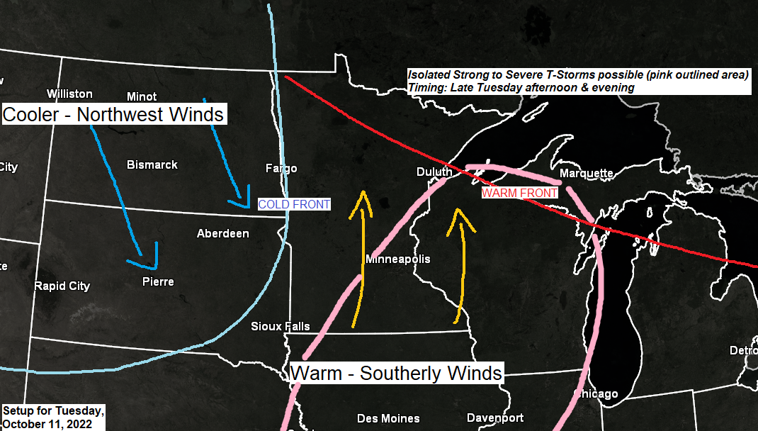
A late summer feel will be in the air Tuesday afternoon as gusty south winds transport warm and somewhat humid air northward into parts of the upper Midwest — Temperatures Tuesday afternoon are forecast to climb into the 70s in much of the Northland with 80s possible across southern Minnesota. Dew points are expected to climb into the 50s while precipitable water increases to around 1.00″ which is pretty humid for this time of year. A strong low-level jet out of the south at upwards of 35 to 55 knots will help advect this higher moisture content air mass into the upper Midwest — And all of this will occur ahead of a strong eastward moving cold front and upper-level trough. Forcing should increase as this system moves closer to Minnesota, and once the cap (warm temps aloft) erodes we should see isolated to scattered showers and thunderstorms erupt from southern to east-central Minnesota and into much of Wisconsin. Timing of these storms looks to be sometime late Tuesday afternoon but more likely Tuesday evening/overnight (somewhere in the 5-8 PM time frame the way it looks now) so storm chances look highest mostly around or after sunset on Tuesday.
Tuesday will be the warmest day of the week.
Wednesday will be a transition day as cooler air filters into the area with highs in the 50s, but then even colder air settles in Thursday and Friday with highs in the 40s, and an even colder air mass is possible Sunday-Monday with highs struggling to get out of the 30s in much of the Northland!

The potential for severe thunderstorms remains on the low side on Tuesday, but isolated strong to severe storms capable of producing hail to quarter size (1″ diameter) and damaging wind gusts to 60 mph can’t be ruled out mainly over northwest Wisconsin and eastern Minnesota.
Note: Mid-level lapse rates will be running between 7.0-8.5 c/km per model guidance which is favorable for large hail development if storms are able to organize enough.

As the low-level jet ramps up later tonight, there is a chance that will see a few isolated showers or thunderstorms develop out in west-central Minnesota, and a few of these showers or thunderstorms assuming they develop could affect southern portions of the Northland Tuesday morning, mainly before 10 AM.
Much of the day Tuesday does look dry in the Northland, and then chances for scattered showers and thunderstorms increase late Tuesday afternoon/evening.
12z NAM 3km model radar forecast valid from Midnight tonight to Midnight tomorrow night.

We’re not looking at any widespread heavy rain with this next system with rain totals generally in the trace to quarter inch range (locally higher amounts possible with thunderstorms) from northeast and far eastern Minnesota into northwest Wisconsin while northern Minnesota misses out on this rain Tuesday night.

A strong upper-level trough will setup from central Canada to the Great Lakes and Ohio Valley from late this week into early next week — This will be a chilly weather pattern for the Northland but also a fairly dry pattern since winds aloft will be coming out of the N/NW or from Canada.

What moisture there is (not a whole lot) will likely squeeze out a few snow showers or mixed showers across much of the Northland for Thursday and Friday with a chance for a light coating of snow accumulation across northern Minnesota and also along the South Shore of Lake Superior in northern Wisconsin.
There is a chance that will see some lake effect snow showers develop off some of the inland lakes in northern Minnesota later this week, and this is pretty typical with these early season cold waves as the cold air moves across the warmer waters.

*Below normal temperatures (blue and green)
*Above normal temperatures (orange, red and white)
Temperature anomaly forecast for October 13-20, 2022

Thanks for reading!
Tim
Leave a Reply