5:06 PM Tuesday, October 18, 2022
An unusually strong and deep trough for this time of the year remains anchored over the eastern Great Lakes today with a chilly northerly flow behind an upper-level low extending all the way down into the southern U.S. today.

Temperatures from Tuesday afternoon, October 18, 2022.

A large portion of the U.S. seeing below normal temperatures today, but the exception to this is over the Northern Rockies and Pacific northwest where above normal temperatures are occurring again today.
That area of warmth over in the northwest U.S. today will eventually make its way into the Northland this weekend with daytime temperatures in the 50s and 60s looking likely in our area from Friday through Sunday, with Sunday currently looking like the warmest of the 3 days.

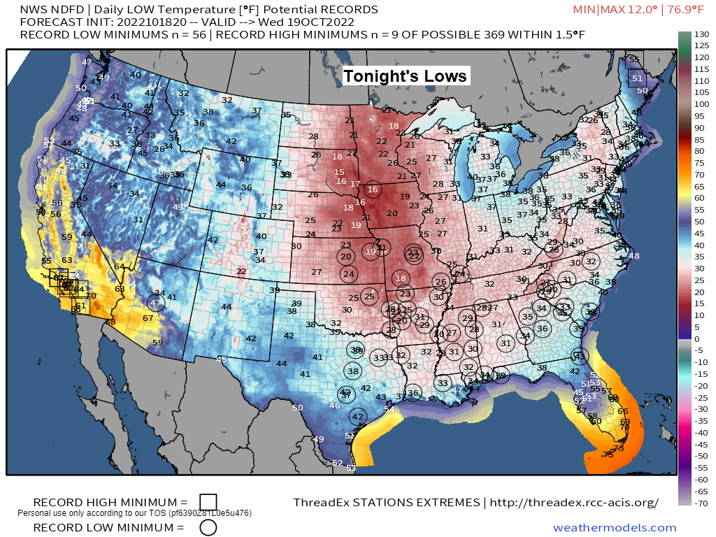
Freeze Warnings are in effect late tonight for the dark blue shaded areas on the map.
Here’s a look at earliest first freeze records that may be broken or close to being broken.
Baton Rouge, LA: October 27
Biloxi, MS: November 1
Birmingham, AL: October 18
Columbus, GA: October 21
Hattiesburg, MS: October 19
Mobile, AL: October 28
Montgomery, AL: October 20
Pensacola, FL: October 31

Mean date for first fall freeze — Note the gold/yellow colors on the map which indicate the mean date for the first fall freeze which is in early to mid-November, or even later into the month of November.

Blue icons on the animation below represent stations which tied or broke their daily record low temperature for October 18th.

We’ve seen quite a change in average monthly temperatures across the Northland over the last week or so, this after a very warm start to October.
| Average Monthly Temperature and Departure from Normal for October 2022 (thru the 17th) Brainerd, MN Average: 49.2 degrees Departure: +0.6 degrees above normal Ashland, WI Average: 47.6 degrees Departure: -0.3 degrees below normal Duluth, MN Average: 46.6 degrees Departure: -0.8 degrees below normal International Falls, MN Average: 45.6 degrees Departure: +1.4 degrees above normal Hibbing, MN Average: 43.6 degrees Departure: +0.3 degrees above normal |
Temperature anomaly for the Lower 48 for October 2022 (thru the 17th)
Red and white – Above normal temperatures
Blue and green – Below normal temperatures

STORM POTENTIAL EARLY NEXT WEEK
A strong upper-level trough (possibly in the form of a negative tilt trough) is forecast to lift northeast out of the Rockies and Western High Plains early next week — The track of this system looks like it will be to the west of the Northland which puts our area on the warmer side of this system meaning that rain will likely be the main precipitation type in northeast Minnesota and northwest Wisconsin. Timing of this rain looks to be from Sunday evening through Monday night.
Note: There will also be a chance for a few thunderstorms in our area Sunday night as elevated instability and moisture increases on southerly low-level winds out ahead of the surface low and trough.

At the moment the NWS Blend of Models is showing a decent amount of precipitation for early next week with widespread totals of 1″+.
Precipitation anomalies in the Northland for October 2022 (thru the 18th)
Duluth, MN: -1.39″ below normal
Brainerd, MN: -1.37″ below normal
Ashland, WI: -1.29″ below normal
International Falls, MN: -0.87″ below normal
Hibbing, MN: -0.82″ below normal

The system for early next week will likely have a snowy side to it, but at the moment it those snow chances are highest well to the west of the Northland.

Thanks for reading!
Tim
Leave a Reply