6:16 PM Monday, October 17, 2022
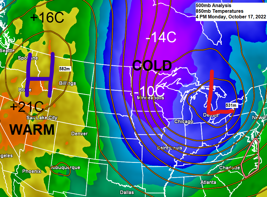
A powerful trough covered the Great Lakes today bringing widespread cold temperatures and gusty winds to the region, while lake effect snow has piled up to 1 to nearly 2 feet (so far) in parts of the Lake Superior snowbelt from northeast Wisconsin into western upper Michigan today!
Goes-16 water vapor loop from Monday, October 17, 2022 (loop time ends 5:01 PM CT)

A very favorable setup in place to produce heavy lake effect snowfall today along portions of the South Shore of Lake Superior in northern Wisconsin and western upper Michigan with cold air (850mb temps -9 to -11C) on north winds blowing over the warmer waters of Lake Superior (water temps +7 to +10 C.
Goes-16 visible satellite loop from Monday, October 17, 2022 (loop time ends 5:01 PM CT)

Here’s a look at a few lake effect snowfall reports from today, Monday, October 17, 2022.
Time of reports included
Gile, WI: 16″ (10:40 AM Monday)
1 mile west of Ironwood, MI: 14.3″ (3:46 PM Monday)
2 miles northwest of Wakefield, MI: 12.0″ (1:15 PM Monday)
1 mile east-southeast of Bergland, MI: 11.4″ (7 AM Monday)
Herman, MI: 9″ (11 AM Monday)
Alberta, MI: 6″ (11 AM Monday)


Lake effect snow with rain or a mix closer to the Lake Superior shoreline will diminish tonight along the South Shore of Lake Superior in northern Wisconsin but expect lake effect snow (rain/mix near the shoreline) to persist in upper Michigan through Wednesday.
18z NAM 3km model radar forecast through 7 PM Wednesday.
Snow (blue)
Rain (green)

A very cold air mass for this time of the year has made its way into the Northland on this 17th of October 2022.
Temperatures across the Northland are only in the upper 20s to low to mid 30s this afternoon.

Temperatures are running some -20 degrees colder than normal across much of the Midwest today.

A cold night ahead in the Northland with lows in the teens and 20s!
However, we probably won’t be setting any new record low temperatures tonight – Here are the record lows for October 18th.
Brainerd, MN: 10 F set in 1976
Hibbing, MN: 15 F set in 1972 and 1992
Ashland, WI: 16 F set in 1948 and 1972
International Falls, MN: 16 F set in 1992
Duluth, MN: 16 F set in 1972

Storm Warning continues through Tuesday for parts of central/eastern Lake Superior.

Waves of 20-24 feet are expected through Tuesday over parts of central/eastern Lake Superior.

A major pattern change is on the way late this week into next week as we replace the massive trough currently over the Great Lakes with ridging, while a trough sets up much farther to the west.

And the temperatures respond to this pattern change, with above normal temperature anomalies covering the eastern half of the US while below normal temperature anomalies cover the western US from late this week into next week.

With this pattern change comes the possibility that will see at least one strong low-pressure system develop while tracking NE across the Rockies and Northern Plains late this weekend into early next week — Details are far from certain at this time, but the potential does exist for some rain, maybe a little snow, wind and possibly even a few thunderstorms across the Northland in the October 23-24 time frame. Stay tuned.

Thanks for reading!
Tim
Leave a Reply