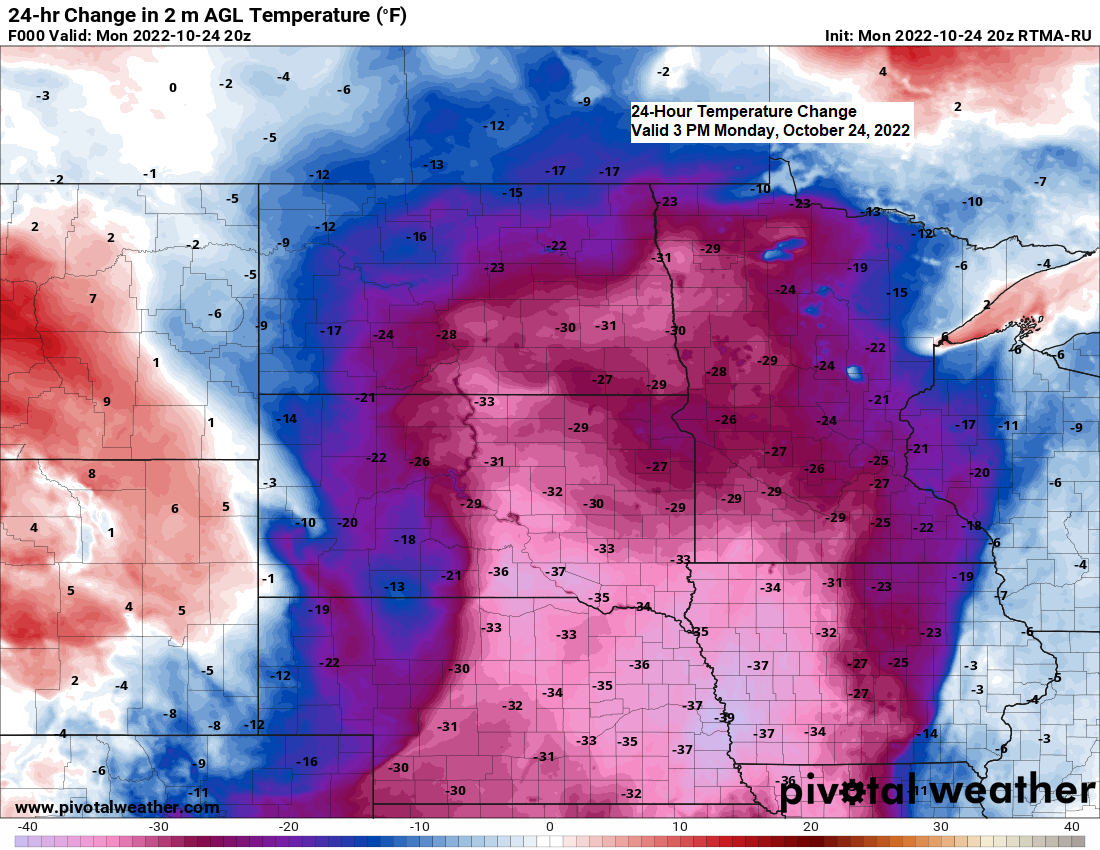
5:00 PM Monday, October 24, 2022
Temperatures are running -15 to nearly -30 degrees colder in Minnesota this afternoon (Monday) compared to the temperatures from Sunday afternoon.
Very warm temperatures in the 70s and even a few 80s were common in Minnesota and Wisconsin on Sunday, but temperatures this afternoon are running closer to normal for this time of year, ranging from the mid 40s to mid 50s, with some 60s holding on for now in the Arrowhead of Minnesota.
A cooling trend will continue over the next few days but we’re not looking at temperatures as cold as they were early last week. Highs Tuesday through Thursday will mainly be in the 40s to around 50 in the Northland which is near normal to slightly below normal in late October.
Precipitation Anomalies for October 2022 (thru 4 PM on the 24th)
Note: I’m not seeing any major systems with rain or snow impacting our area for the rest of this month, so October 2022 will likely finish well below normal in the precipitation department since we’re already running well over -1″ below normal for the month.
Ashland, WI: -1.62″ below normal
Duluth, MN: -1.58″ below normal
Brainerd, MN: -1.54″ below normal
Hibbing, MN: -1.09″ below normal
International Falls, MN: -1.06″ below normal
A windy day in the Northland – Peak Wind Gusts from Monday, October 24, 2022.
International Falls, MN: 44 mph
Brainerd, MN: 43 mph
Ashland, WI: 42 mph
Duluth, MN: 41 mph
Hibbing, MN: 37 mph
Thunderstorms which developed in Minnesota and Wisconsin Sunday night into early Monday morning contained frequent lightning strikes.

| Local Storm Reports from Sunday night/Monday morning, October 23-24, 2022 Source: NWS Duluth, MN 1:33 AM 10/24: Hail 0.25 inch. Duluth, MN (National Weather Service) St. Louis County. 1:15 AM 10/24: Hail 0.25 inch. Duluth, MN (National Weather Service) St. Louis County. Hail fell for about 2 minutes. 11:32 PM 10/23: Hail 0.50 inch. Knife River, MN (Lake County) 11:00 PM 10/23: Hail 0.25 inch. Remer, MN (Cass County) |
| Rainfall Reports from Sunday night-Monday morning, October 23-24, 2022 Source: NWS Duluth, MN; MesoWest The Bay of Grand Marais, MN: 1.45″ 2 S Tower, MN: 0.56″ Silver Bay, MN: 0.53″ Two Harbors, MN: 0.52″ Seagull Lake, MN: 0.51″ Isabella, MN: 0.48″ Wolfridge, MN: 0.42″ Duluth Sky Harbor Airport: 0.41″ Longville, MN: 0.41″ 25 E Ely, MN: 0.40″ Hayward, WI: 0.40″ Bigfork, MN: 0.38″ Cable, WI: 0.35″ Floodwood, MN: 0.33″ Duluth, MN (Airport) 0.32″ Deer River, MN: 0.31″ Embarrass, MN: 0.28″ Brimson, MN: 0.27″ Cloquet, MN: 0.27″ 4 W Clam Lake, WI: 0.26″ Ely, MN: 0.25″ Eveleth-Virginia, MN: 0.25″ Winter, WI: 0.24″ Brainerd, MN: 0.22″ 3 E Orr, MN: 0.21″ International Falls, MN: 0.20″ Cass Lake, MN: 0.20″ Walker, MN: 0.20″ Bruno, MN: 0.18″ Grand Rapids, MN: 0.17″ Chisholm-Hibbing Airport: 0.16″ Cook, MN: 0.15″ Pine River, MN: 0.15″ Hinckley, MN: 0.14″ 3 E Wright, MN: 0.14″ Moose Lake, MN: 0.12″ South Range, WI: 0.12″ Washburn, WI: 0.08″ Glidden, WI: 0.08″ Solon Springs, WI: 0.06″ 3 S Ashland, WI: 0.05″ Minong, WI: 0.03″ Hurley, WI: 0.02″ |
Here’s a look at radar estimated rainfall totals from Sunday evening through 4 AM Monday, October 24, 2022.

Southwest mid to upper-level flow continues over the upper Midwest today with another disturbance embedded in the flow lifting N/NE out of the Central Plains late today.
Goes-16 water vapor loop from Monday, October 24, 2022 (loop time ends 4:11 PM Monday)

A little rain is likely tonight over northwest Wisconsin and far eastern Minnesota and the Arrowhead.
A few rain or mixed rain/snow showers are possible for a time Tuesday morning around the International Falls area and points west/southwest, but no snow accumulation is expected.
18z NAM 3km model radar forecast through 1 PM Monday.

Total precipitation for tonight.

Looks like will see higher 500mb heights and ridging build back into the Great Lakes region later this week and this weekend.

Much above normal temperatures are forecast in northeast Minnesota and northwest Wisconsin late this week into early next week, and possibly even into the middle of next week with highs in the 50s and 60s likely in our area.

We may begin to see a bit of a pattern change sometime during the first week of November.

And it’s certainly possible will see these much above normal temperature anomalies trend cooler in future model runs over the next several days, but for now we’re looking at another stretch of much above normal temperatures from November 1-6.

Thanks for reading!
Tim
Leave a Reply