4:33 PM Thursday, October 27, 2022
Just when it looked like we were about to get into a cooler/stormier and possibly snowier weather pattern in the Northland later next week, things changed considerably in model guidance last night and that trend has continued into today, so the prospects of getting a winter weather event and cooler weather in the Northland later next week are quickly fading, but still can’t totally be ruled out yet since this is still about 7 days away, and the pattern by late next week is looking pretty chaotic in the computer models.
Overall, this looks more or less like a blowtorch temperature pattern for much of the U.S. through the 1st and 2nd week of November with widespread well above average temperatures in the forecast.
This type of temperature pattern pretty much guarantees that any precipitation we do get in the Northland would be in the form of rain in early November since there is very little to no cold air for a system to tap into as the real cold air will be bottled up well to the west and northwest of the upper Midwest.
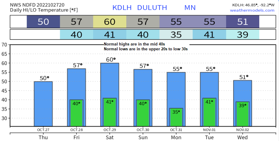
Note: High temperatures in the 50s and 60s are likely in northeast Minnesota and northwest Wisconsin from October 28th through at least November 3rd, and possibly beyond, and there is even a chance albeit a slight one for highs to approach 70 degrees in parts of the Northland around the middle of next week.


Fall 2022 currently ranks as a top 10 driest fall on record in the darker brown areas, this would include for southeast North Dakota, northeast South Dakota, western-southern Minnesota and northern Iowa.

A weak system is bringing a little light rain and drizzle to portions of the Northland this afternoon and expect areas of light rain and drizzle to linger into this evening before ending overnight tonight. Most of this rain will remain focused over northeast into east-central Minnesota and into parts of northwest Wisconsin.
This rain won’t amount to much, but it is the only precipitation will see in our area until perhaps later next week or next weekend.
MRMS radar loop ending 4:04 PM Thursday, October 27, 2022.

October 27, 2022 – Drought Update
Minnesota
4% of the state is in Extreme Drought, unchanged from last week.
16% of the state is in Severe Drought, up from 15% last week.
44% of the state is in Moderate Drought, unchanged from last week.
78% of the state is Abnormally Dry, unchanged from last week.

Wisconsin
3% of the state is in Severe Drought, unchanged from last week.
24% of the state is in Moderate Drought, unchanged from last week.
66% of the state is Abnormally Dry, up from 64% last week.

0.02% of the Midwest is in Exceptional Drought, down from 0.36% last week.
3% of the Midwest is in Extreme Drought, unchanged from last week.
17% of the Midwest is in Severe Drought, up from 15% last week.
50% of the Midwest is in Moderate Drought, up from 43% last week.
82% of the Midwest is Abnormally Dry, up from 78% last week.
Currently 17% of the Midwest is drought free, this is down from 58% of the Midwest which was drought free back on July 26, 2022.

Yellow areas have seen a 1 to 2 class degradation in drought conditions over the last 2 months or from October 25, 2022, compared to August 30, 2022.

Midwest 4-week Drought Monitor Class Change from October 25, 2022, compared to September 27, 2022.
Parts of Kentucky have seen a 3-class degradation in drought conditions, while other areas in lighter orange have seen a 1 to 2 class degradation in drought conditions over the last month.

Soil moisture anomaly as of October 26, 2022
Orange and red areas – Dry
Green areas – Wet

Thanks for reading!
Tim
Leave a Reply