5:55 PM Tuesday, November 8, 2022
- Low pressure will move through the area quicker than what it looked like 24 hours ago. Result from this will be for the heavier precipitation to fall through Thursday with mostly light precipitation on Friday.
- Several waves of rain with embedded heavy downpours and isolated thunderstorms are likely through mid-afternoon Thursday affecting east-central Minnesota, the Twin Ports, and all of northwest Wisconsin.
- Isolated strong thunderstorms are possible Wednesday through about mid-afternoon Thursday in eastern Minnesota and northwest Wisconsin.
- Occasional rain showers in far northern Minnesota through Wednesday night mixing with and changing to snow on Thursday. Snow could be heavy at times during the day Thursday with lingering light to moderate snow expected for Thursday night. Travel could be difficult Thursday and Thursday night across northern Minnesota and Arrowhead.
Here’s my snowfall forecast for Thursday through Friday evening.
Trace to 1″ amounts for Duluth with the changeover from rain to snow not occurring until sometime Thursday night with lingering snow showers and flurries likely on Friday. Temperatures will fall from the around 40 Thursday afternoon to near the freezing mark by early Friday morning, with highs on Friday only in the lower 30s.
Note: The greatest snow accumulations with this storm on Thursday should remain north of Duluth so that hasn’t changed at all in the computer models over the last few days.

In addition to the snow, there is also a risk for some sleet and freezing rain in far northern Minnesota on Thursday with some ice accumulation possible.

There will likely be some breaks in the rainfall at times tonight and Wednesday.
Precipitation should be all rain until early Thursday morning, that’s when we will begin to see the rain transition to snow or mixed precipitation in far northern Minnesota.
18z NAM 3km model radar forecast through 6 AM Thursday.
Rain (green)
Snow (blue)
Mixed Precipitation (pink/purple)

Widespread 1″-2″ precipitation totals are expected in the Northland through Friday afternoon with some 3″ totals possible in eastern Minnesota and northern Wisconsin.

Heavy rain is possible at times through Thursday afternoon in parts of the Northland which may lead to isolated instances of flash flooding (green shaded area on maps below), but with how dry it’s been in our area over the last few weeks this should reduce the risk for widespread flooding.


A strong low-pressure system currently over California will move quickly to the ENE over the next few days with the surface and upper-level features passing over the upper Midwest Thursday into early Friday.
Goes-16 water vapor loop from Tuesday, November 8, 2022.

STORM TRACK FORECAST
Low pressure crosses the Rockies through Wednesday then lifts quickly NE from far northwest Iowa to eastern Lake Superior between Thursday morning and Friday morning — The center of this low is forecast to track near or west of Duluth on Thursday which keeps us on the warmer/eastern side of this storm which means that all the precipitation we see in Duluth will be rain through Thursday afternoon, then as the low exits off to the east, colder air gets pulled up from the SW changing the rain to a little snow Thursday night.

A very moist air mass for this time of the year will continue to lift NE into eastern Minnesota and northern Wisconsin tonight, and this humid air mass will remain over these areas through about mid-afternoon on Thursday.
Precipitable water values increasing to around 1.00″ to 1.25″ will cause occasional heavy downpours from tonight through Thursday afternoon from eastern Minnesota into northern Wisconsin.

An 850mb jet upwards of 55 knots has setup over the upper Midwest this afternoon leading to a strong warm air and moisture advection pattern.

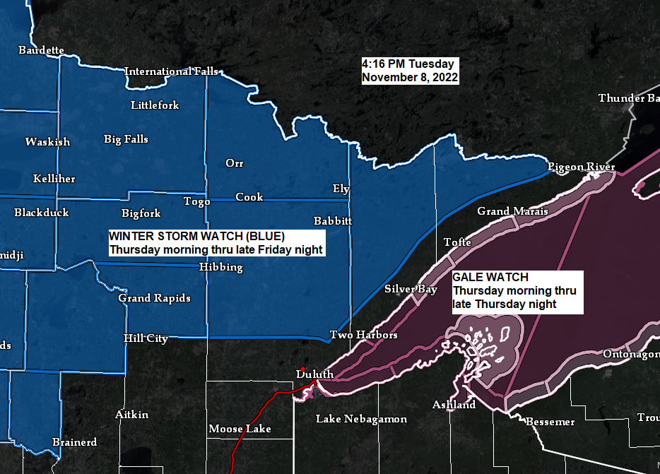
We’re still looking at a round of strong northeast winds near Lake Superior and Twin Ports on Thursday with wind gusts of 30 to 50 mph, but winds will diminish by late Thursday night.
Wind gust forecast valid 6 AM Thursday to Midnight Friday.

Waves will increase to 6 to 12 feet on western Lake Superior Thursday afternoon into Thursday night. Since this system is moving through quicker, the duration of strong NE winds and big waves will be shorter in duration.

Thanks for reading!
Tim
Leave a Reply