5:57 PM Monday, November 7, 2022
- Chances for scattered showers and isolated thunderstorms will be on the increase in the Northland late Tuesday afternoon or Tuesday night with brief heavy downpours and occasional lightning being the primary hazards with this activity.
- The potential for more scattered showers and isolated thunderstorms with heavy rainfall continues Wednesday and Wednesday night especially from east-central Minnesota into northern Wisconsin.
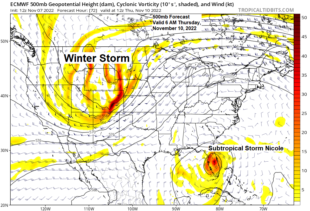
- A powerful storm arrives on Thursday and continues through Friday. This storm will bring heavy snow, rain, a few thunderstorms, sleet and some freezing rain (ice accumulations) to the Northland.
- Colder temperatures move in behind this late week storm with lingering snow showers and flurries likely this weekend.
Here’s the latest storm tracks per 12z ensemble models from Monday — Still seeing some differences regarding the storm track for late this week with a few models tracking the low farther to the west/north, while others are slightly farther to the south/east. It should be noted the 18z NAM model this afternoon trended quite a bit colder which leads to more of a wintry mix of precipitation as far south as Duluth for Thursday evening/night, while other models are warm enough for precipitation to fall mostly as rain in Duluth. Stay tuned!

Areas from north-central Minnesota into the Arrowhead of Minnesota continue to have the greatest potential for significant snowfall and or ice accumulations Thursday afternoon through Friday.
Blue – Best chance for >6″ snowfall
Orange – Best chance for ice accumulations of >0.05″
Freezing rain/icing potential is greatest Thursday afternoon into early Friday morning.
Locations farther south including Duluth and Superior will also see some snow out of this storm, but probably not until Friday, but accumulations should be much lower compared to areas farther to the north.

| Precipitation Anomalies since September 1, 2022 Twin Cities, MN: -5.20″ below normal Grand Forks, ND: -4.05″ below normal St. Cloud, MN: -3.41″ below normal Duluth, MN: -3.25″ below normal Eau Claire, WI: -2.90″ below normal International Falls, MN: -2.32″ below normal |
Still looking at widespread precipitation totals of 1-3″+ in all of northeast Minnesota and northwest Wisconsin from Tuesday afternoon through Friday, with the highest amounts forecast over northwest Wisconsin into far eastern Minnesota.

FLOOD POTENTIAL
A cold front will be moving east out of the Dakotas Tuesday and Wednesday with this boundary eventually stalling out in a SW-NE fashion from southwest Minnesota into upper Michigan Wednesday night. Deep moisture transport into this front on a strong southerly low-level jet will set the stage for training of showers and thunderstorms with a potential for excessive rainfall to develop Wednesday night in the green area on the map below.

Looks mainly dry in the Northland through Tuesday morning, but after that will see scattered showers and isolated thunderstorms develop later Tuesday afternoon through Tuesday night.
18z NAM 3km model radar forecast valid 1 PM Tuesday to 1 PM Wednesday.

GALE AND STORM FORCE WINDS POSSIBLE OVER LAKE SUPERIOR
This storm for Thursday and Friday will also have a lot of wind with it.
Northeast gales and possible storm force winds are likely over western Lake Superior for Thursday into early Friday with 15-foot waves possible early Friday morning near the South Shore of Lake Superior, with 8-to-12-foot waves possible at the southwest arm of Lake Superior including for the Twin Ports Harbor.

STORM FUEL
A classic November storm late this week with warm air getting pulled NW into the low-pressure center while colder air pushes in from the SW.

This temperature contrast should help fuel a strong storm late this week.

An incredibly humid (for November) air mass with dew points in the 50s to lower 60s in much of southern/eastern Minnesota and Wisconsin for Wednesday and Thursday.

Dew point temperature anomalies for Wednesday and Thursday across central and southern Minnesota into Wisconsin will be running +30 to +35 degrees above where they should be for this time of the year.

Severe thunderstorms are possible on Thursday over parts of southern Minnesota and Iowa with a risk for a few tornadoes, large hail and damaging winds. Note: We may see this risk for severe weather on Thursday extend farther northeast in future updates.

NICOLE
Subtropical Storm (Nicole) is forecast to strengthen to hurricane or near hurricane status as it makes landfall north of Miami, FL or between Port Saint Lucie and West Palm Beach, FL early Thursday morning.

Goes-16 water vapor loop from Monday, November 7, 2022 (loop time ends 5:10 PM CT)
A large storm covering the western U.S., while Nicole continues to slowly organize well to the east of Florida this afternoon.

Thanks for reading!
Tim
Leave a Reply