5:16 PM Sunday, November 6, 2022
It’s been a very windy Sunday across the Northland with westerly winds of 25 to 45 mph with gusts to 50 mph! The strong winds have led to numerous power outages in the Northland this afternoon.
Peak Wind Gusts from Sunday, November 6, 2022
Duluth Airport: 50 mph
Brainerd, MN: 50 mph
Ashland, WI: 48 mph
International Falls, MN: 38 mph
Hibbing, MN: 36 mph
Strong west winds will continue in the Northland tonight through Monday morning with wind gusts of 30 to 45 mph. Winds will slowly diminish by Monday afternoon.
HRRR model wind gust forecast through 9 AM Monday.

| Local Storm Reports for Sunday, November 6, 2022 Source: NWS Duluth, MN; Minnesota Power 4:15 PM: Non-Thunderstorm Wind Gust. 51 mph. 2 SSW Hinckley, MN (Pine County) 4:00 PM: Non-Thunderstorm Wind Gust. 53 mph. 13 NE Sand Bay, WI (Ashland County) 2:16 PM: Non-Thunderstorm Wind Gust. 51 mph. 4 NE Hermantown, MN (St. Louis County) 2:00 PM: Non-Thunderstorm Wind Damage. Floodwood, MN (St. Louis County) Power outages in the Floodwood area affecting 68 people. Wind gusts in the area were 35-45 mph around time of report in the general area. 1:55 PM: Non-Thunderstorm Wind Gust. 53 mph. 1 S Duluth, MN (St. Louis County) 1:47 PM: Non-Thunderstorm Wind Gust. 51 mph. 4 NE Brainerd, MN (Crow Wing County) 1:29 PM: Non-Thunderstorm Wind Damage. 3 NNE Rice Lake, MN (St. Louis County) 52 people without power by either downed powerlines or downed trees falling on power lines. West wind gusts in the general area around the time of report were 35-40 mph. 1:15 PM: Non-Thunderstorm Wind Damage. 1 S Cloquet, MN (Carlton County) Power outages in the Cloquet area this afternoon affecting approximately 20 people. Westerly wind gusts in the general area around the time of report were 40-48 mph. 1:12 PM: Non-Thunderstorm Wind Damage. 5 ENE Nemadji, MN (Carlton County) A power outage affecting 18 people this afternoon. Westerly wind gusts in the general area at the time of the report were 30-40 mph. 1:00 PM: Non-Thunderstorm Wind Damage. 1 WSW Lester Park, MN (St. Louis County) Power outages in the Lester Park area of Duluth this afternoon affecting approximately 1807 people. Westerly wind gusts in the general Duluth area around the time of report were 35-45 mph. |


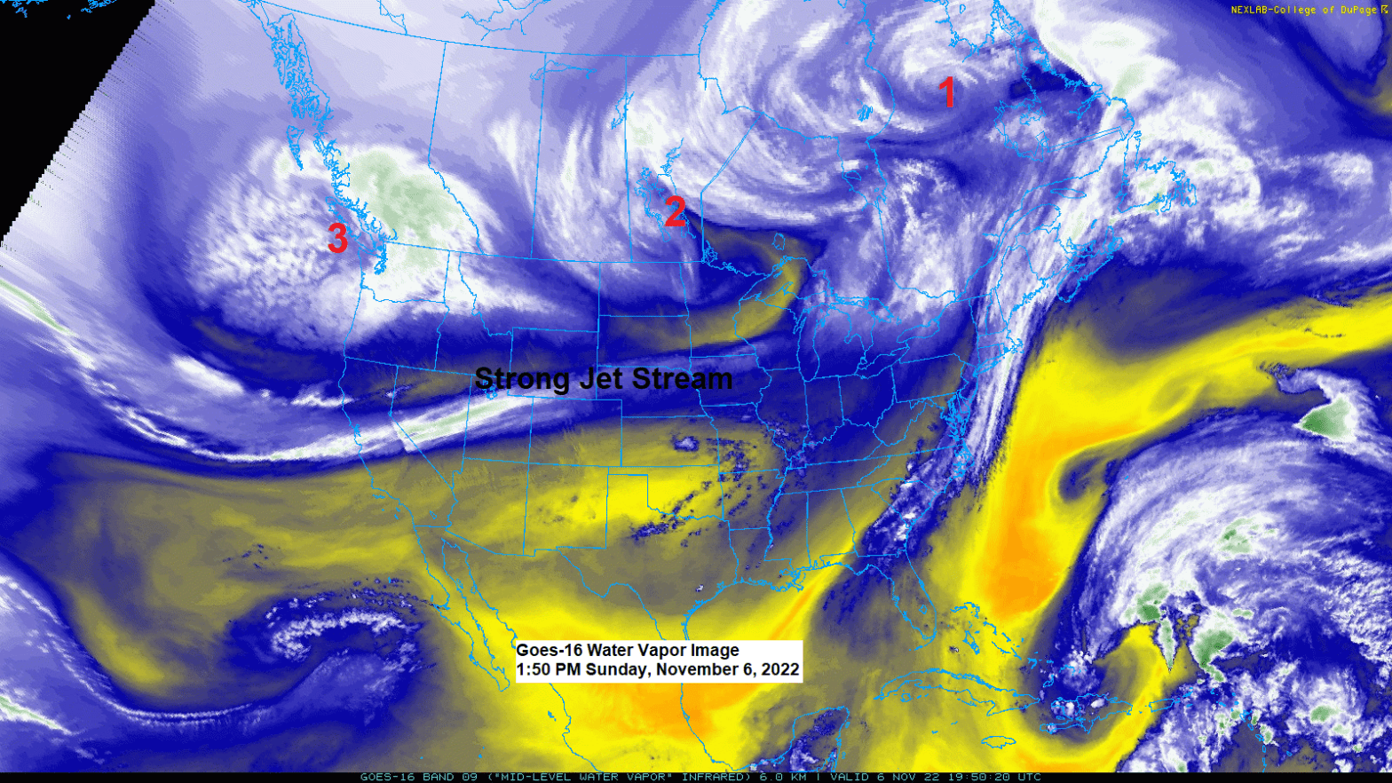
A strong jet stream with winds >140 knots covered areas from south-central Oregon to Lower Michigan today.
Three strong low-pressure systems were found north of this jet stream today, with the system currently over Manitoba and Ontario having a direct effect on the Northland’s weather today in the form of strong westerly winds.
Goes-16 water vapor loop from Sunday, November 6, 2022.


Also, of note today is this wildfire which is burning in northern South Dakota, well southwest of Aberdeen, or near and slightly west of Loyalton, SD, and the smoke plume of this fire is showing up nicely on visible satellite imagery this afternoon.


LATE WEEK WINTER STORM POTENTIAL
A strong area of low-pressure is forecast to develop over eastern Colorado on Wednesday. This low is then expected to track northeast through Friday. The exact track of this low remains uncertain per the 12z model run from today, with the Euro model still showing a more northerly track to the low compared to a farther south storm track per GEFS and Canadian models.
A farther south storm track would allow for colder air to work farther south into the Northland which would increase the risk for some wintry precipitation even in Duluth late Thursday into Friday, while a more northerly storm track would mean more rain than snow on Thursday, with a changeover to some snow after the system departs on Friday.
This system has the potential to produce a swath of significant snow accumulations of >6″ somewhere from the northern Plains to upper Midwest from Thursday into Friday.
There is also a chance for an area of freezing rain/sleet with some ice accumulation late this week in between the transition zone from rain to snow.

A strong mid to upper-level area of low pressure (blue and green colors) is forecast to track ENE from the Rockies to the Great Lakes from Thursday through Saturday per EPS model forecast.

The storm for late this week also has a chance to produce very strong NE winds near Lake Superior including in Duluth with wind gusts of 40-55+ mph possible Thursday into early Friday. Gusty winds could also occur farther inland from Lake Superior late this week.
Here’s the 12z European model wind gust forecast from 6 AM Thursday to 6 AM Friday.

Here’s my preliminary forecast for where I think the greatest snow and or ice accumulations will setup later this week, but since this event is still several days out, this forecast will probably change a few times over the next few days.

Widespread precipitation totals of 1-2″+ are possible in all of northeast Minnesota and northwest Wisconsin from Tuesday afternoon through Friday, with totals of 3″+ possible over parts of northwest Wisconsin and far eastern Minnesota.

Thanks for reading!
Tim
Leave a Reply