6:41 AM Sunday, November 6, 2022
Wind will be an issue today.
A strong area of low pressure will cross Manitoba and Ontario today with a tight pressure gradient found south of that low.
West winds will increase in the Northland by mid to late morning with winds at their strongest this afternoon/early this evening. Wind gusts of 30 to 45 mph are possible in much of the Northland through this evening.
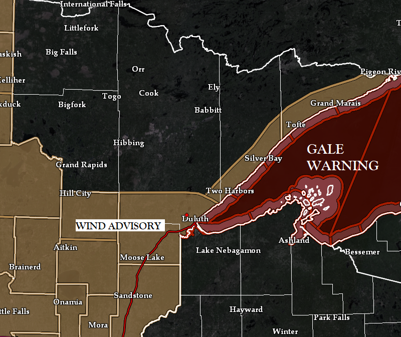
Note: Wind Advisory is in effect from 12 PM to 6 PM today for southern parts of the Northland including Cass Lake, Walker, Pine River, Brainerd, Aitkin, Hill City, McGregor, Floodwood, Duluth, Cloquet, Moose Lake, Hinckley and Pine City, and from 3 PM today to 6 AM Monday for the North Shore of Lake Superior including Two Harbors, Silver Bay and Grand Marais.

Today’s system is also bringing some precipitation to the Northland early this Sunday morning with rain being the main precipitation type, but this rain won’t last very long, perhaps an hour or two at most in any given location, and this area of precipitation will quickly exit off to the NE by mid to late morning.
Precipitation totals have ranged from around 0.01″ to 0.08″ for locations which have seen some precipitation early this Sunday morning.
Will likely see some snow showers and flurries develop this afternoon into this evening mainly in far northern Minnesota (along and north of a line from Grand Rapids to Ely) but snowfall amounts should be <1″.
HRRR model radar forecast through 10 PM Sunday.
Rain (green)
Snow (blue)

WINTER STORM POTENTIAL LATE THIS WEEK (Nov. 10-11)
Computer models are showing what could be the first widespread major winter weather event to impact the Northland this fall happening later this week, but before then a lead system with warmer air to work with will cause periods of rain and isolated thunderstorms in much of the Northland from Tuesday afternoon through Wednesday.
Regarding the late week system – Computer models disagree on the storm track with the EPS (Euro ensemble model) showing the low taking a track more to the north, while the GEFS (GFS ensemble model) takes the low farther to the south, but computer model storm track differences with a system that is 4 days out happens almost 99% of the time.
Note: A more southerly storm track would probably increase the potential for wintry precipitation in Duluth, while a track farther to the north would keep a lot of the precipitation as rain in Duluth, with some snow at the end of the system on Friday.

Here’s the European model forecast for Thursday evening (6 PM)
Snow, possibly heavy to the north, rain to the south with a few thunderstorms possible as well, with a wintry mix including some potential for ice accumulation in between.
Wind also looks to be a component (and possibly a big one at that) to this late week storm with northeast winds possibly gusting >40 mph near Lake Superior and in Duluth Thursday into early Friday.

Widespread precipitation totals of 1-2″ or more are possible in all of northeast Minnesota and northwest Wisconsin from Tuesday through Friday.

Currently the greatest potential for 6″+ snow totals is north of Duluth for late this week, but this forecast will probably change a few times over the next few days with the axis of highest snow amounts possibly shifting farther north or south.


Thanks for reading!
Tim
Leave a Reply