6:03 PM Thursday, November 10, 2022
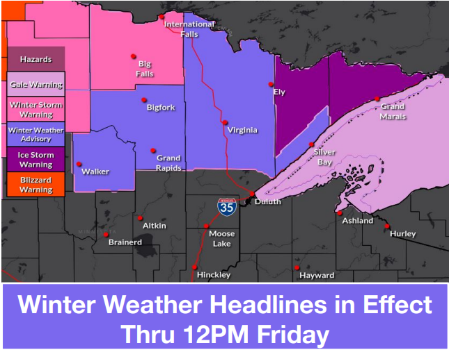
A fall storm will continue to affect the Northland tonight and Friday.
- Snow or a wintry mix of precipitation switches over to all snow in northern Minnesota tonight.
- Areas of rain and drizzle farther south in the Northland should change over to snow showers and flurries either late tonight or Friday morning, this includes areas from east-central Minnesota to the Twin Ports into northwest Wisconsin. Patchy freezing drizzle is also possible early Friday morning. Note: Total snowfall accumulations of a trace to an inch are possible in Duluth by Friday afternoon.
- Strong northeast winds of 25 to 50 mph near Lake Superior and in the Twin Ports will diminish this evening (after 7 PM)
- Much colder temperatures across the entire Northland through this weekend with highs mostly in the mid 20s to low 30s with overnight lows in the teens and 20s.
The strong winds in the Duluth area have caused some power outages today, and there’s also been a few other power outages elsewhere in the Northland today.

18z NAM 3km model radar forecast through 6 PM Friday.
Snow (blue)
Rain (green)
Mixed Precipitation (pink)
Note: Rain changes over to snow showers and flurries in Duluth later tonight (after 10 PM) Patchy freezing drizzle is also possible for a time early Friday morning. Snow showers and flurries will likely continue during the day Friday.

Expected snowfall storm totals by 6 PM Friday.

Additional ice accumulation through 6 AM Friday morning.

| 24-Hour Precipitation Reports from November 9-10, 2022 (ending 4 PM on the 10th) Source: MesoWest Barnes, WI: 2.79″ Ashland, WI: 2.54″ Duluth, MN (Airport) 2.21″ Poplar, WI: 2.12″ Solon Springs, WI: 2.09″ Washburn, WI: 2.09″ Clam Lake, WI: 2.08″ Minong, WI: 1.96″ Duluth Sky Harbor Airport: 1.95″ Aitkin, MN: 1.93″ Hinckley, MN: 1.92″ Saginaw, MN: 1.91″ Two Harbors, MN: 1.89″ Esko, MN: 1.87″ Cable, WI: 1.85″ Odanah, WI: 1.84″ French River, MN: 1.81″ McGregor, MN: 1.74″ Cloquet, MN: 1.60″ Hill City, MN: 1.53″ Bayfield, WI: 1.52″ Siren, WI: 1.47″ Brainerd, MN: 1.44″ Hayward, WI: 1.25″ Superior Airport: 1.25″ Glidden, WI: 1.21″ Moose Lake, MN: 1.16″ Grand Rapids, MN: 1.15″ Chisholm-Hibbing Airport: 1.12″ Ely, MN: 1.09″ Isabella, MN: 1.08″ The Bay of Grand Marais, MN: 1.08″ Webb Lake, WI: 0.96″ Winter, WI: 0.95″ Eveleth-Virginia, MN: 0.71″ Spooner, WI: 0.70″ Deer River, MN: 0.67″ Longville, MN: 0.63″ Walker, MN: 0.42″ Cass Lake, MN: 0.35″ Pine River, MN: 0.31″ International Falls, MN: 0.23″ |
Record 24-Hour Precipitation at Brainerd and Hibbing today.
Brainerd, MN
New record for 11/10: 1.26″
Old record for 11/10: 0.72″ set in 1919
Hibbing, MN:
New record for 11/10: 1.20″
Old record for 11/10: 0.54″ set in 1998
An elongated low-pressure system extended from west-central Minnesota to north-central Wisconsin late this afternoon. Cold air was found west and north of this system today with widespread snow, sleet and freezing rain from the Dakotas to northern Minnesota, while warmer air out ahead of this system kept precipitation in the form of rain, and there’s also been a few thunderstorms as well.
Very strong northeast winds have been occurring near Lake Superior today with wind gusts of 40-50 mph.

There’s been reports of around a foot or more of snow in parts of central North Dakota today.

Saw quite a bit of lightning with the thunderstorms which moved through parts of the region last night/this morning.

Two large systems impacting the Lower 48 today.
A winter system across the northern Plains, and a tropical system over the southeast U.S.

A look at both systems on Goes-16 water vapor imagery.
Loop time ends 4:10 PM Thursday, November 10, 2022.

Thanks for reading!
Tim
Leave a Reply