3:48 PM Sunday, November 27, 2022
A low-pressure system which was over southern Saskatchewan today will move slowly east across southern Manitoba from Monday into Tuesday. Southerly winds ahead of this system will bring a shot of warm air advection snowfall to parts of northern Minnesota Monday into Monday evening with up to an inch of snow possible.
A few lake effect snow showers are possible along the North Shore of Lake Superior (mainly northeast of Silver Bay) early Monday morning ahead of the system snow which arrives in the Arrowhead later in the day on Monday.
Note – A brief period of snow is possible in Duluth Monday afternoon from roughly Noon to 2 PM with total snowfall accumulations of less than 1″.
18z NAM 3km model radar forecast valid from Midnight tonight to Midnight Monday night
(Snow in blue)

Here’s the NWS Blend of Models snowfall forecast for Monday.

An active weather pattern is in place with several strong low-pressure systems evident on Goes-16 water vapor imagery.

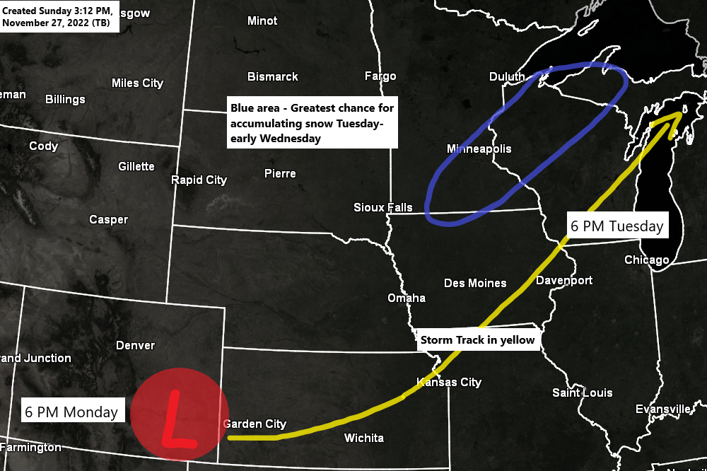
TUESDAY SNOW CHANCES
Computer models continue to shift the axis of snow from one model run to the next, but the trend in the models today has been for this area of snow to shift farther to the south/east, and this lowers the potential that will see much snow in Duluth and in far northwest Wisconsin on Tuesday.

An outbreak of severe thunderstorms including a risk for strong tornadoes exists on Tuesday across parts of the lower to mid-Mississippi Valley.
Orange – Numerous severe storms possible
Yellow – Scattered severe storms possible

Frigid air continues to build well to our north, and eventually we may see some of this arctic air push south into the Northland, but it doesn’t look like that may happen until sometime in the December 4-6 time frame, so although temperatures will be cooler this week, we’re not looking at anything too cold through most of this week in the Northland.

The Euro ensemble (EPS) model continues to open up the flood gates for arctic air to push south into the northern tier of the U.S. during the December 4-9 time frame.

| Average Temperature and Departure from Normal in the Northland for November 2022 (thru the 26th) Ashland, WI: 34.3 F (+1.1 degrees above average) Brainerd, MN: 32.9 F (+1.3 degrees above average) Duluth, MN: 31.6 F (+0.8 degrees above average) Hibbing, MN: 28.1 F (+1.5 degrees above average) International Falls, MN: 27.7 F (+0.4 degrees above average) |
Average monthly temperatures for November 2022 have ranged from below average across the western U.S. to above average from the Great Lakes to the eastern U.S.

Snowfall Totals for November 2022 (thru the 26th)
International Falls, MN
Month to Date: 11.9″
Normal to Date: 10.0″
Departure: +1.9″ above normal
Percent of Normal Snowfall: 119% of normal
Duluth, MN
Month to Date: 10.2″
Normal to Date: 11.8″
Departure: -1.6″ below normal
Percent of Normal Snowfall: 86% of normal

Thanks for reading!
Tim
Leave a Reply