6:25 PM Wednesday, November 30, 2022
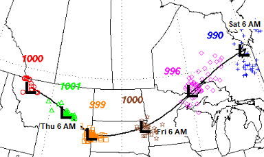
Another round of snow and strong winds are possible in the Northland late Friday afternoon through Saturday morning as an area of low pressure moves quickly northeast out of South Dakota, passing near or north of Duluth Friday evening.
Although a major winter storm with significant amounts of snow is unlikely with this system, there is still a potential for some impacts due to a few inches of snow along with falling temperatures and strong winds which could lead to areas of blowing snow, and possibly even a flash freeze type scenario in parts of the Northland due to the rapidly falling temperatures Friday night.
Here’s my preliminary snowfall forecast for Friday’s event.
Note – There is also a possibility that will see some mixed precipitation for a brief time Friday afternoon-early Friday evening in parts of the Northland.

Temperatures are expected to warm into the 30s in much of the Northland on Friday with a few 40s even possible especially in parts of northwest Wisconsin, but temperatures will drop quickly Friday night as arctic air rushes in, with temperatures by 6 AM Saturday forecast to range from around zero to 10 above in the Northland.


Northwest winds increase with gusts of 25 to 45 mph in northeast Minnesota and northwest Wisconsin Friday evening-Saturday morning.

Looking back at my snowfall forecast compared to what actually happened during Tuesday’s snow event.
Overall, not too bad considering how complex this system was, and the computer models not really handling the western edge of the snow shield very well.
My Forecast

Actual Snow Amounts

| Final Snowfall Reports from November 29-30, 2022 Source: NWS Duluth, Minnesota 13 ENE Gordon, WI: 9.8″ 3 SW Lake Nebagamon, WI: 9.5″ Gile, WI: 9.0″ 4 SSW Ashland, WI: 8.0″ Lake Nebagamon, WI: 8.0″ Washburn, WI: 8.0″ 1 E Cable, WI: 8.0″ 3 S Cornucopia, WI: 7.5″ Cozy Corner, WI: 7.5″ Ashland, WI: 7.3″ Brule, WI: 7.0″ Mellen, WI: 7.0″ Herbster, WI: 6.5″ Spooner, WI: 6.0″ Winter, WI: 6.0″ 2 E Siren, WI: 6.0″ 8 W Hovland, MN: 6.0″ 3 N Amnicon Falls State Park, WI: 5.7″ Danbury, WI: 5.5″ Hayward, WI: 5.0″ Port Wing, WI: 5.0″ 3 NNE Trego, WI: 5.0″ 2 WNW Holyoke, MN: 5.0″ 7 W Wascott, WI: 4.6″ 7 WSW Hovland, MN: 4.5″ 4 NW Minong, WI: 4.0″ 4 NE Patzau, WI: 4.0″ 4 SSE Webster, WI: 3.3″ Hovland, MN: 3.0″ 2 WNW Superior, WI: 3.0″ 1 W Silver Bay, MN: 2.8″ 3 WSW Lutsen, MN: 2.7″ Duluth, MN: 2.2″ (Official NWS Duluth) 1 SW Duluth, MN: 2.0″ 3 ENE Grand Marais, MN: 1.8″ Wrenshall, MN: 1.8″ Two Harbors, MN: 1.4″ |
Thanks for reading!
Tim
Leave a Reply