6:15 PM Thursday, December 1, 2022
A quick moving low-pressure system will move NE out of South Dakota on Friday. This system will bring a variety of impacts to the Northland Friday afternoon/Friday night
- Potential for a flash freeze in parts of east-central Minnesota early Friday evening as mild above freezing temperatures during the day Friday fall rapidly below freezing Friday evening.
- A burst of snow late Friday afternoon/evening spreading W-E across the Northland.
- Areas of light wintry mix precipitation Friday afternoon/early Friday evening.
- Areas of blowing snow Friday night through Saturday morning.
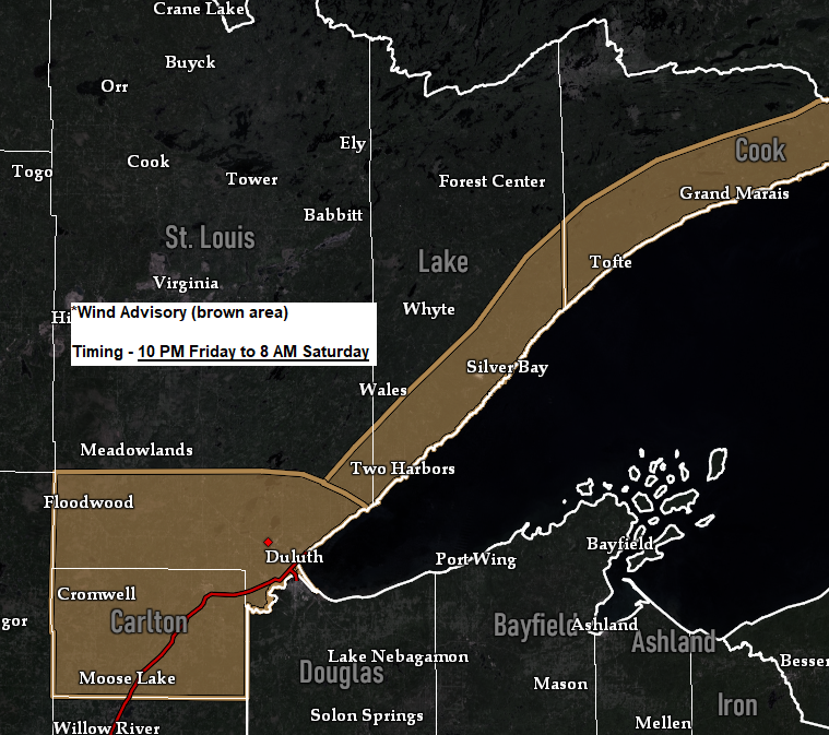
- Strong NW winds with gusts of 25 to 50 mph Friday evening through Saturday morning.
- Arctic air Friday night into Saturday, highs only in the single digits and teens on Saturday.
Snow develops across north-central Minnesota Friday afternoon (mid to late afternoon) spreading farther east by early Friday evening.
18z NAM 3km model radar forecast valid 9 AM Friday to 6 AM Saturday.
Snow (blue)

A look at the 500mb trough which will move across the region Friday.

For Duluth – Some snow is likely beginning around 5-7 PM Friday, ending by Midnight. Total snowfall accumulations around 1″. Above freezing temperatures Friday afternoon. Arctic air hits with falling temperatures after 7 PM Friday evening. Strong NW winds develop Friday evening (6-8 PM) with wind gusts 25 to 45 mph.
Here’s my snowfall accumulation forecast.

A big-time temperature contrast sets up on Friday with temperatures during the afternoon ranging from around 70 along the Nebraska-Kansas state line to the single digits above zero in northwest Minnesota to around -10 degrees in southern Saskatchewan!

Temperatures warm into the 30s to around 40 degrees in northwest Wisconsin and eastern Minnesota Friday afternoon, including here in Duluth where we should see temperatures rise into the mid to upper 30s Friday afternoon.

Arctic air will then overspread the area from W-E Friday evening/overnight with temperatures falling into the single digits below to single digits above zero across the Northland.

Strong northwest winds develop Friday evening and will continue overnight into Saturday morning.
Wind gusts of 25 to 45 mph are expected in much of the Northland during the aforementioned time frame, with gusts as high as 50 mph possible especially along the North Shore of Lake Superior.

Wind chill temperatures fall into the single digits below zero to around 20 below zero in the Northland Friday evening-Saturday morning.

Thanks for reading!
Tim
Leave a Reply