6:17 PM Wednesday, December 7, 2022
- A break in the snowfall is on the way for Thursday and Friday with milder temperatures
- Areas of low clouds and fog are possible Thursday night into Friday
- Snow chances return Saturday along with a chance for some patchy freezing drizzle
- A major storm could impact the Northland next week bringing a variety of precipitation types to the area
A milder southerly flow moving over the colder snowpack could lead to the development of low cloudiness and areas of fog in much of the Northland Thursday night through Friday morning.
HRRR model visibility forecast valid 6 PM Thursday to Noon Friday
Visibility <1 mile in the purple shaded area.

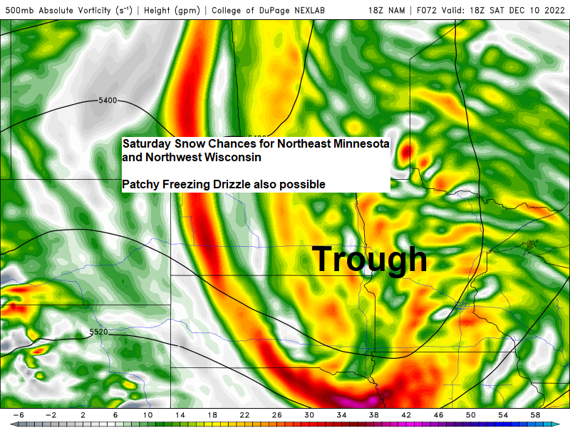
SATURDAY SNOW CHANCES
A trough of low pressure approaching from the Northern Plains will produce some weak lift as it moves across the Northland on Saturday which will lead to some light snow and possibly some patchy freezing drizzle.
Snow totals should remain on the light side on Saturday with totals somewhere in that half inch to 2-inch range, although some higher snow totals are possible along the North Shore due to a possibility for terrain enhanced snowfall with ESE winds in place.
European model radar forecast valid 6 AM Saturday to 9 PM Saturday (snow in blue)

| Another round of snow in parts of the Northland this morning Here are a few snowfall reports from Wednesday, December 7, 2022 Source: NWS Duluth, MN 1 WNW Hayward, WI: 2.0″ 3 N Amnicon Falls State Park, WI: 1.4″ 7 WSW Pine River, MN: 1.0″ Duluth, MN: 0.5″ (Official NWS Total) SLR of 10:1 |
STORM POTENTIAL NEXT WEEK
A strong and potentially slow-moving low-pressure system and upper-level trough is forecast to eject NE out of the Rockies next week. This storm may affect the Northland next week bringing all kinds of weather to the area.
Precipitation types and amounts will depend on the storm track, as well as where a dry slot ends up.
With all that said, this storm has the potential to be a significant event in the Northland.

GEFS ensemble model precipitation type forecast valid for 6 PM Tuesday, November 13, 2022
Snow (blue)
Rain (gree)

Seeing very good agreement at this point in regard to precipitation totals for next week, and wow that is a lot of precipitation per ensemble model data.
If all this falls as snow, then we’re talking about at least a foot or more of snow given the QPF totals.
Will see how the models trend over the next few days as there is still plenty of time for things to change.


| Fall 2022 Climate Summaries for the Northland September 1 through November 30 Duluth, MN Average Temperature: 45.1 degrees Normal: 43.7 degrees Departure: +1.4 degrees above average Highest Temperature: 85 on September 1 Lowest Temperature: 5 on November 20 and November 30 Total Precipitation: 7.15″ Normal: 8.35″ Departure: -1.20″ below average Percent of Normal Precipitation: 86% of normal Total Snowfall: 18.0″ Normal: 16.9″ Departure: +1.1″ above average Percent of Normal Snowfall: 106% of normal International Falls, MN Average Temperature: 42.6 degrees Departure: +2.1 degrees above average Total Precipitation: 4.51″ Normal: 6.61″ Departure: -2.10″ below average Percent of Normal Precipitation: 68% of normal Total Snowfall: 15.5″ Normal: 13.8″ Departure: +1.7″ above average Percent of Normal Snowfall: 112% of normal Brainerd, MN Average Temperature: 47.2 degrees Departure: +2.3 degrees above average Total Precipitation: 5.04″ Normal: 5.87″ Departure: -0.83″ below average Percent of Normal Precipitation: 86% of normal Hibbing, MN Average Temperature: 41.4 degrees Departure: +1.8 degrees above average Total Precipitation: 5.39″ Normal: 6.50″ Departure: -1.11″ below average Percent of Normal Precipitation: 83% of normal Ashland, WI Average Temperature: 45.9 degrees Departure: +1.0 degree above average Total Precipitation: 8.24″ Normal: 7.41″ Departure: +0.83″ above average Percent of Normal Precipitation: 111% of normal |
51% of days were warmer than average in Duluth during Fall 2022 vs. 41% of days which were colder than average.

Fall 2022 Average Temperature Ranks by Climate District.

Fall 2022 Total Precipitation Ranks by Climate District.
Note – Darker brown areas represent a top 10 driest fall on record.


Thanks for reading!
Tim
Leave a Reply