12:38 PM Wednesday, December 14, 2022
One thing has been apparent with the first part of this winter storm, and it’s that this has been an elevation driven snow event this morning, with a snowfall gradient ranging from 10″ on top of the hill at the National Weather Service in Duluth, to about 1.5″ of snow, 1 mile east-southeast of West Duluth, Minnesota. Crazy stuff! Oh, and there was also some thundersnow in Duluth this morning which is always an awesome event when it happens.
A longer duration of sleet and freezing rain led to lower snowfall amounts in the Northland last night, but bands of heavy snow moved through much of the area this morning producing significant amounts of wet heavy snow.
Note — 2nd part of this winter storm begins this evening/overnight and continues through Thursday with more wet snow along with heavy snowfall rates at times — More on this later today.
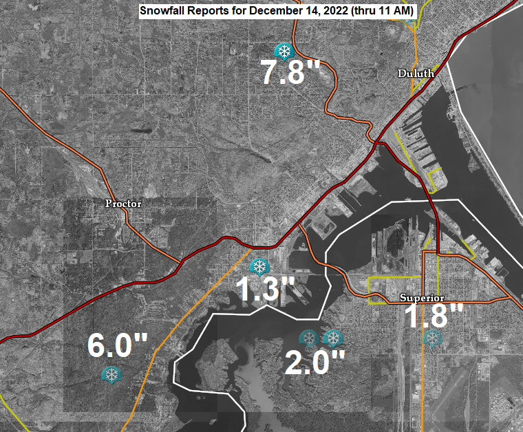
| Snowfall Reports from Tuesday night-Wednesday morning Source: National Weather Service Duluth, MN Duluth, MN: 10.3″ (Official total at the NWS thru 12 PM today) 7 W Finlayson, MN: 10.0″ 5 E Leader, MN: 9.0″ 1 S Brimson, MN: 8.5″ 1 NW of Barnum, MN: 8.0″ Moose Lake, MN: 8.0″ Brainerd, MN: 8.0″ 2 WNW Duluth, MN: 7.8″ 4 NE Palisade, MN: 7.0″ 2 S Rice Lake, MN: 7.0″ 1 WNW Minong, WI: 6.9″ 2 N Beroun, MN: 6.9″ — Lots of damage to trees 1 SE Hibbing, MN: 6.0″ 4 SSE McKinley, MN: 6.0″ 3 NNE Duluth, MN: 6.0″ 2 NNW Gary New Duluth, MN: 6.0″ Wright, MN: 6.0″ Coleraine, MN: 5.6″ 3 WNW Remer, MN: 5.5″ 6 N Deer River, MN: 5.5″ 4 E Cloverdale, MN: 5.5″ 4 SE Lake Shore, MN: 5.0″ 1 NNE Cloquet, MN: 4.7″ 4 NNE Stone Lake, WI: 4.5″ — 0.10 to 0.15″ of ice 6 NE Hertel, WI: 4.5″ 1 SW Grantsburg, WI: 4.2″ 1 W Buyck, MN: 4.0″ 1 SSW Pine City, MN: 3.7″ 3 N Amnicon Falls State Park, WI: 3.0″ Winter, WI: 2.3″ 1 ESE West Duluth, MN: 1.3″ |

A dry slot continues to advance north into parts of the Northland early this afternoon with snow tapering off to drizzle and freezing drizzle, but snow (heavy at times) continues near Lake Superior and in far northern Wisconsin.
Radar loop ending 12:20 PM Wednesday, December 14, 2022.
Note — Light snow continues on top of the hill thru 5 PM today with about 1 to 2 inches of additional accumulation with a lot more to come later tonight. Lower elevation areas (closer to Lake Superior) will see a mix of drizzle and light snow this afternoon.

Power Outage Update
Minnesota Power — 74 active outages as of 12:32 PM affecting 5,557 customers.

Thanks for reading!
Tim
Leave a Reply