4:56 PM Tuesday, December 13, 2022
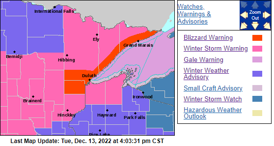
*BLIZZARD WARNING*
Blizzard Warning is in effect until 6 PM Thursday for the North Shore of Lake Superior including the cities of Duluth, Two Harbors, Silver Bay and Grand Marais.
-Travel could be very difficult to impossible.
-Heavy snowfall combined with strong winds will cause snow loading on trees and powerlines. This will likely cause power outages.
-Travel should be restricted to emergencies only.

Here’s my updated snowfall forecast thru 6 PM Thursday.
15 to 24 inches of snow is possible on top of the hill in Duluth by Thursday evening, with 10 to 15 inches of snow possible in lower elevation (closer to Lake Superior) Note – If more mixing occurs than what is forecast, then snow totals may end up a little lower, especially closer to Lake Superior.
Note – There is a chance that snow totals in both the 15-to-24-inch zone, and the 24-to-30-inch zone are not high enough, so some further updates to my snowfall forecast are possible.

Ice Accumulation Forecast
Source: National Weather Service Duluth, MN

Snow and a wintry mix will continue spread farther north across the Northland tonight.
Dry slot lifts south to north across the area Wednesday afternoon/evening with precipitation rates diminishing, but this will be followed by another surge of heavier snowfall late Wednesday night into Thursday.
For Duluth
- Snow or a wintry mix develops this evening (between 7 PM and 10 PM)
- Heavy wet snow overnight through about mid-afternoon Wednesday followed by some light snow, drizzle and freezing drizzle through Wednesday evening. Timing for when the heavier snow ends in Duluth is between 1 PM and 3 PM Wednesday.
- Snowfall rates could approach 1 to 2 inches/hour late tonight through Wednesday morning.
- Snow increases again late Wednesday night (after 10 PM) with snow then continuing through Thursday afternoon.
- Additional snow showers are then expected from Thursday night through Saturday with mostly light additional accumulations the way it looks now.
- East to northeast winds gusting 25 to 45 mph through early Thursday afternoon will lead to occasional whiteout conditions in falling and blowing snow with blizzard conditions expected at times.
- This will be a very wet snowfall with SLR’s forecast to be in the 7:1 to 9:1 range. Typically, in our area the snowfall ratio is around 12:1.
HRRR model radar forecast thru 12 PM Thursday.
Snow (blue)
Mixed Precipitation (pink & purple)
Rain (green)

This will be a long duration storm as will see the surface low, which was over central Nebraska this afternoon, reach northwest Wisconsin but not until Friday morning.

A rich supply of juicy air continues to flow north out of the Gulf of Mexico and into the upper Midwest this evening ahead of a strong low over Nebraska.

Widespread precipitation continues to lift north across Minnesota this evening.
Radar loop ending 4:40 PM Tuesday, November 13, 2022.

The reason behind why this storm will move very slowly is because of this very blocky upper-level pattern that is in place.

A powerful storm across the region today.
Goes-16 water vapor loop from Tuesday, December 13, 2022.

A little bit of everything on the headlines map today.
Blizzard and Winter Storm Warnings across the northern Plains to the upper Midwest, while a threat for tornadoes and flooding continues tonight over parts of the southern Plains. Meanwhile out west, freeze warnings are in effect for parts of central California through the early to middle part of next week, and also in parts of southern Arizona through Thursday.

Thanks for reading!
Tim
Leave a Reply