5:37 PM Monday, December 12, 2022
-A long duration winter storm begins late Tuesday Afternoon-Evening with two distinct rounds of heavier precipitation expected through Friday.
-The first round occurs Tuesday night through about mid-afternoon Wednesday.
-Dry slot approaches from the south and spreads north across the Northland Wednesday afternoon and evening, and as this dry slot moves over the area will see precipitation taper off to drizzle/freezing drizzle for several hours, but the exception to this will be along the North Shore of Lake Superior where some snow should continue to fall Wednesday night due to an east wind coming off the lake resulting in some lake enhanced snow.
-A second round of heavier snow moves through the area on Thursday followed by some lingering snow showers and light snowfall for Friday and possibly even into Saturday.
-East to northeast winds of 15 to 30 mph with gusts to 40 mph are expected near Lake Superior Tuesday through Thursday with areas of blowing snow likely. Brief whiteout conditions are possible along the North Shore of Lake Superior due to the falling and blowing snow.
Here’s my updated snowfall forecast thru Wednesday evening (10 PM)
Note – Additional snowfall accumulations are expected Thursday and Friday, but this forecast only covers the expected snow amounts through Wednesday evening.
For Duluth — 8 to 13 inches of snow are possible from Tuesday night through Wednesday evening, with additional snowfall accumulations expected Thursday into Friday. Snow or a wintry mix reaches Duluth Tuesday evening between 8 PM and 10 PM, but prior to the onset of the steadier precipitation, there could be some patchy drizzle, freezing drizzle and snow flurries during the day Tuesday. Dry slot reaches the Twin Ports late Wednesday afternoon (between 3 PM-6 PM) with snow tapering to drizzle and freezing drizzle.

European model radar forecast valid 6 AM Tuesday to 6 PM Wednesday.
Snow (blue)
Wintry Mix — Snow, rain, sleet, freezing rain (pink & orange)
Rain (green)

Some ice accumulation is possible in parts of the Northland Tuesday evening through Wednesday, with parts of east-central Minnesota and northwest Wisconsin having the greatest chance for ice accumulations of up to 0.10″.

There will be plenty of moisture streaming north out of the Gulf of Mexico and into the Northland late in the day Tuesday into Wednesday out ahead of an area of low-pressure lifting NE out of Colorado.

Low pressure over eastern Colorado early this evening will track slowly northeast, then east-northeast as it reaches southern Minnesota around daybreak on Thursday.

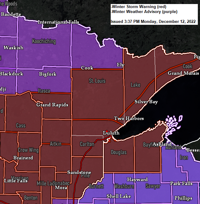
This will be a far-reaching winter storm with widespread winter weather alerts in place.


A powerful winter storm covering the Rockies today.
Goes-16 water vapor loop from Monday, December 12, 2022.

Here’s a look at the European model precipitation type forecast for the first part of this two-part winter storm.
6 AM Tuesday to 12 PM Tuesday
Mostly dry in northeast Minnesota and northwest Wisconsin although a few lake effect snow showers are possible along the North Shore of Lake Superior, and some patchy flurries or drizzle/freezing drizzle is possible over other parts of the Northland, but no major impacts are anticipated from this spotty precipitation.
Leading edge of the precipitation at 12 PM Tuesday marked by the black line on map.
Snow (blue)
Mix (pink)
Rain (green)

12 PM Tuesday to 6 PM Tuesday
Snow or a wintry mix reaches southern portions of the Northland (south of Duluth)
Leading edge of the precipitation at 6 PM Tuesday marked by the black line on map.

6 PM Tuesday to Midnight Wednesday
Snow or a wintry mix spread farther north into the Northland.

12 AM Wednesday to 6 AM Wednesday
Snow or a wintry mix across the entire Northland.

6 AM Wednesday to 12 PM Wednesday
Snow or a wintry mix continues across the Northland, but a dry slot will begin to approach from the south.

12 PM Wednesday to 6 PM Wednesday
Snow continues in far northern Minnesota and along the North Shore of Lake Superior with snow or a mix across far northern Wisconsin, while a dry slot continues to lift north out of central Minnesota.

6 PM Wednesday to 12 AM Thursday
Much of the Northland should be in the dry slot Wednesday evening with the exception of the North Shore of Lake Superior where snow continues to fall.

Thanks for reading!
Tim
Leave a Reply