5:58 PM Friday, December 30, 2022
After a cooler day today (highs closer to normal for this time of year) will see temperatures warm back up this weekend with highs in the mid 20s to low-mid 30s Saturday and Sunday.
Areas of fog are possible late tonight through Sunday morning, and some light snow and patchy freezing drizzle is also possible Saturday into Saturday night.
Duluth needs an additional 0.5 inches of snow by Midnight Saturday to set a new monthly snowfall record for December. Snowiest December on record in Duluth was in 1950 with 44.3 inches of snow. So far this December Duluth has picked up 43.9 inches of snow and it doesn’t look very likely that will squeeze out another 0.5 inches of snow the rest of this month.
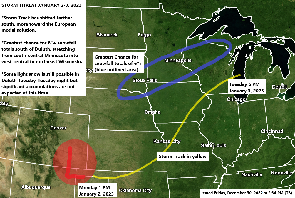
A winter storm could impact portions of the upper Midwest and western Great Lakes early next week.
- There has been a notable trend toward a farther south storm track in model runs today, with the majority of the computer models trending toward what the European model had been showing for a few days now.
- This does appear to be a fairly quick moving system with Tuesday looking like the day that could have some heavier snowfall and travel impacts across southern portions of the Northland, or from eastern Minnesota into northwest Wisconsin.
- Some light snow could affect the Twin Ports Tuesday and Tuesday night, but significant snow accumulations are not expected at this time.
- This potential storm is still a few days away and some more changes to the storm track and timing could occur through this weekend.
Note — The Twin Ports isn’t out of the woods just yet on getting into the swath of highest snow accumulations early next week, but the trend in the computer models last night and today is definitely toward the heavier snow setting up south of Duluth and Superior.
Looking at the 12z EPS 50-member snowfall forecast for Duluth for early next week shows 6/50 (12% of members) with 10″+ snow totals, while 17/50 (34% of members) have 6″+ snow totals. The number of members showing 10″+ and 6″+ snow totals continue to decrease.
The blue area on the image below represents the area with the greatest chance for significant snowfall accumulations of 6 inches or more for early next week. This area could shift a bit more to the north or a little farther south over the next few days.

A warm front lifting north out of southern Minnesota combined with an area of low-pressure moving ESE out of Alberta could bring enough forcing to the Northland to produce a little light snow and freezing drizzle for Saturday and Saturday night but no major or widespread impacts from snow and ice are expected.
18z NAM 3km model radar forecast valid from 6 AM Saturday to 6 AM Sunday.

A light glaze of ice accumulation is possible in parts of the Northland Saturday afternoon into Saturday night.

Euro ensemble model continues to show a mild temperature pattern for the Northland next week.

GEFS model has been trending a bit cooler for the Northland next week per last 3 model runs.
Blue – Below average temperatures
Orange, Red and Pink – Above average temperatures

| A look at the climate Normals and records for January at Duluth, Minnesota Normal high on the 1st: 21 Normal low on the 1st: 5 Normal high on the 31st: 21 Normal low on the 31st: 2 Average monthly temperature for January: 11.2 degrees Highest: 23.7 degrees set in 2006 Lowest: -7.2 degrees set in 1912 Average precipitation: 0.95″ Wettest: 4.70″ set in 1969 Driest: 0.13″ set in 2008 Average snowfall: 16.8″ Snowiest: 46.8″ set in 1969 Least snowy: 2.0″ set in 1921 Average number of subzero nights: 14 Most: 27 set in 1982 and 1929 Fewest: 1 set in 2006 13 days have at least 0.1″ of snow 5 days have at least 1.0″ of snow Snowfall Totals for Duluth, Minnesota for January (2011-2022) Normal snowfall is 16.8″ Only 3 Januarys dating back to 2011 have had above average snowfall in Duluth. 2011: 18.5″ (above average) 2012: 5.1″ (below average) 2013: 9.2″ (below average) 2014: 9.4″ (below average) 2015: 6.6″ (below average) 2016: 13.0″ (below average) 2017: 15.5″ (below average) 2018: 9.1″ (below average) 2019: 10.4″ (below average) 2020: 17.7″ (above average) 2021: 9.1″ (below average) 2022: 17.1″ (above average) Temperature Anomalies for Duluth, Minnesota for January (2011-2022) Average temperature is 11.2 degrees Note — Dating back to 2011, there’s been 7 Januarys with an above average monthly temperature compared to 5 which have had a below average monthly temperature. 2011: -4.1 degrees 2012: +6.8 degrees 2013: +0.9 degrees 2014: -9.6 degrees 2015: +1.5 degrees 2016: +1.6 degrees 2017: +4.8 degrees 2018: -0.2 degrees 2019: -3.6 degrees 2020: +4.9 degrees 2021: +6.7 degrees 2022: -6.5 degrees |
Outlook for January 2023
CFS model
For Northeast Minnesota and Northwest Wisconsin — Above average temperatures

Last 10 CFS model runs temperature anomaly trends for January 2023
Orange, red and pink: Above average temperatures

Precipitation
For Northeast Minnesota and Northwest Wisconsin — Above average precipitation

Last 10 CFS model runs precipitation anomaly trends for January 2023
Green and blue: Above average precipitation
Yellow and brown: Below average precipitation

Thanks for reading!
Tim
Leave a Reply