5:28 PM Thursday, December 29, 2022
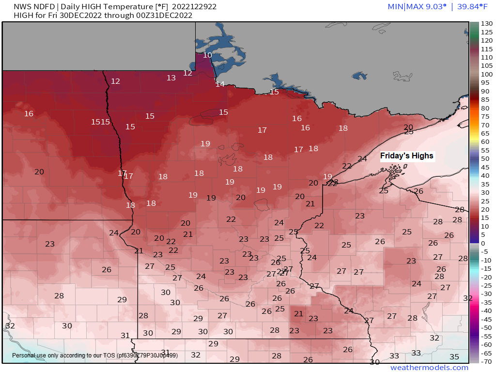
Temperatures will fall back toward more seasonal levels on Friday with highs in the mid 10s to low to mid 20s in northeast Minnesota and northwest Wisconsin. It also looks blustery as northwest winds increase with gusts of up to 15 to 25 mph late tonight into Friday.
High was 35 in Duluth today (December 29th) First time above freezing since December 15th, and today’s high of 35 matches the warmest temperature for the month which first occurred on December 2nd.
An additional 1.3 inches of snow is needed in Duluth by Midnight Saturday night in order to break the December snowfall record which was set in 1950 with 44.3 inches of snow. If we’re going to break this record, I think it will have to happen with tonight’s system.
A fast moving but fairly strong system continues to lift northeast into the upper Midwest late this afternoon.
This system for tonight consists of two parts, one with some northern energy, the other associated with some southern energy, and it’s that southern piece of energy which will lift quickly NE through parts of the Northland tonight bringing stronger vertical lift which will cause some heavier snow in a relatively narrow band somewhere from east-central to northeast Minnesota into far northwest Wisconsin.

A narrow band of snow and a wintry mix will affect portions of the Northland tonight with precipitation coming to an end from SW-NE early Friday morning.
For Duluth — Freezing drizzle and drizzle possible through about mid-evening followed by a period of snow from around 8 PM to 1 AM tonight.
21z HRRR model radar forecast through 6 AM Friday.

No changes made to my snowfall forecast for tonight’s event.
For Duluth — Total snowfall accumulations ranging from a trace to 2 inches.

Warm air is in place across parts of the Northland late today with 850mb temperatures of around +1 to +5C so these temperatures will need to cool at least to 0C before we see some snow.
Note — If precipitation occurs prior to when 850mb temps fall to 0C or lower then we could see some rain or sleet and perhaps even some patchy freezing rain.

There’s quite a variation in temperatures across the region today ranging from the single digits and 10s in eastern North Dakota to the middle 30s in eastern Minnesota to the mid 50s to the 60s from southern and eastern Iowa to Illinois into far southern Wisconsin.

A look at the system which will affect parts of the Northland tonight.
Goes-16 water vapor loop from Thursday, December 29, 2022 (loop time ends 3:46 PM CT)

STORM POTENTIAL EARLY TO MIDDLE OF NEXT WEEK
Another set of model runs today hasn’t cleared anything up in regard to the storm track for next week with big time differences continuing between the GFS and Euro models.
The Euro camp remains the furthest south, and even nudged a little more south compared to 24 hours ago, while the GFS, Canadian, German-Icon and UK models are farther north with the storm track for early next week.
It’ll likely take a few more days for the computer models to resolve these storm track differences, but for now either storm track remains plausible.
Note — Euro model has been consistent for 3 runs now keeping the heavier snow south of Duluth early next week.

EPS 50-member snowfall forecast for Duluth for early next week
8/50 (16% of members) show snow amounts of 10″+ — This is up from 12% on Tuesday.
19/50 (38% of members) show snow amounts of 6″+ — This is down from 42% on Tuesday.
Using the EPS (Euro ensemble model) shows the highest probabilities for 6 inches or more of snow for early next week covering areas from south-central Minnesota into northern Wisconsin and western upper Michigan with much lower chances for 6″+ snow amounts across northern Minnesota and into the Arrowhead.

Thanks for reading!
Tim
Leave a Reply