5:41 PM Wednesday, January 4, 2023
And the snow continues!
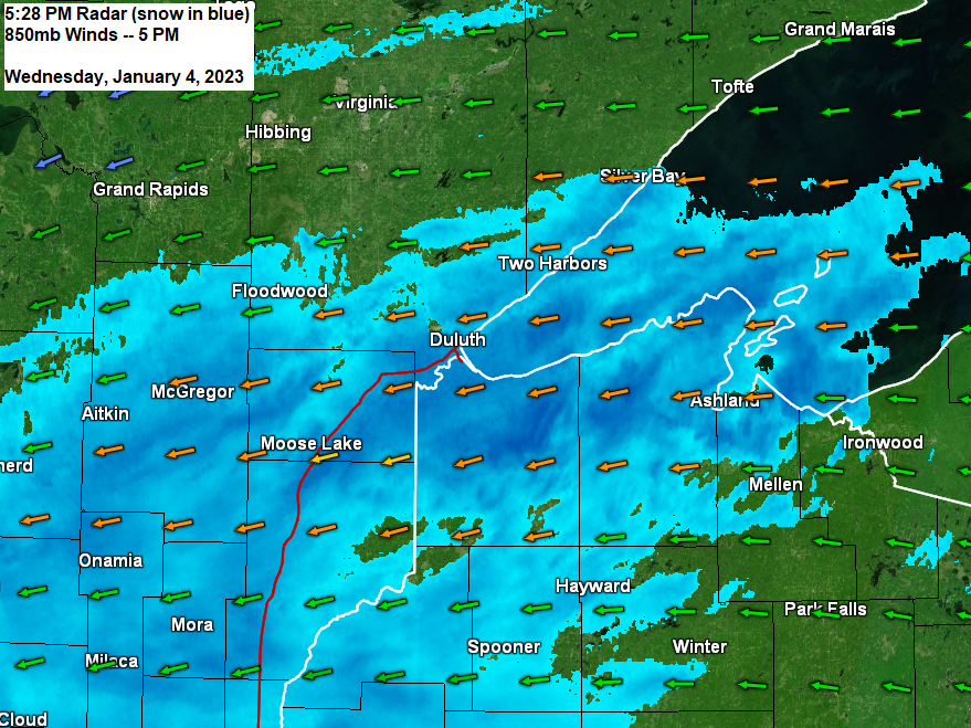
Low pressure both at the surface and aloft has moved very little since this morning, but it will finally start to pull away from the Northland tonight, and once that happens the snow will come to an end, but this will probably be a slow process, with the snow tapering off from NW-SE in east-central Minnesota and northwest Wisconsin later tonight-Thursday morning.
Highs for Thursday and Friday will be in the mid 10s to the 20s so nothing arctic behind this winter storm, but overnight lows for Thursday night and Friday night will likely drop to the single digits below zero in parts of the Northland.
It’ll remain windy tonight with northeast to north-northeast winds gusting 20 to 40 mph, but winds will diminish considerably on Thursday to 10 to 15 mph. Areas of blowing snow will linger tonight especially near Lake Superior.

Blocked upper-level pattern with a ridge to the north and an upper low to the south. The low to our south can’t lift north due to the ridge in Ontario, so the low is forced to move underneath said ridge. The pattern this week is pretty similar to the pattern we saw with the blizzard before Christmas.

Upper low which has been more or less parked along the Minnesota-Iowa state line is starting to show signs of moving to the south/southeast late this afternoon, and that is a good sign for those tired of all the snow.
Goes-16 infrared satellite loop from Wednesday, January 4, 2023 (loop time ends 4:41 PM CT)

Updated Snowfall Totals for the January 3-4, 2023, Winter Storm
Totals thru 5 PM on January 4th
3 N Pleasant Valley, MN: 14.5″
1 SSE Scotts Corner, MN: 12.0″
1 NNW Moose Lake, MN: 12.0″
Hawthorne, WI: 11.0″
4 NW Minong, WI: 10.0″
7 E Patzau, WI: 9.5″
1 NE West Duluth, MN: 9.0″
Mason, WI: 9.0″
2 SSE Esko, MN: 8.5″
1 NNE Duluth, MN: 8.0″
3 N Amnicon Falls State Park, WI: 7.3″
Glidden, WI: 7.2″
1 N Cloquet, MN: 7.0″
Pine Center, MN: 7.0″
2 E Palisade, MN: 7.0″
1 WNW Breezy Point, MN: 7.0″
Butternut, WI: 7.0″
7 ESE Brainerd, MN: 6.9″
6 NW Knife River, MN: 6.5″
2 NNE Duluth, MN: 6.3″
2 SW Two Harbors, MN: 5.5″
Gile, WI: 5.5″
1 S Twig, MN: 4.6″
Duluth, MN: 4.6″ (Official total at the NWS thru 4 PM Wed.)
2 WNW Saginaw, MN: 4.0″
For Duluth — Snow diminishes overnight tonight between 2 AM and 4 AM.
Snow tapers off in eastern Minnesota and most of northwest Wisconsin later tonight.
Snow lingers longest along the South Shore of Lake Superior in northwest Wisconsin, in fact the snow over that area probably won’t diminish completely until sometime tomorrow afternoon.
18z NAM 3km model radar forecast through 6 PM Thursday.

Additional Snowfall Tonight
For Duluth — Another 1-3 inches of snow is possible tonight.

Looking ahead to next week’s temperatures shows a lack of arctic air.
Looks like will have high temps in the 10s and 20s in the Northland next week with lows mostly above zero, and for January that isn’t bad at all.
Note — I am keeping an eye on a system for the middle to end of next week for our next shot to get some more snow in the Northland, but no need to panic yet as that is still a week out and many things will probably change between now and then on the computer models.

GEFS model temperature anomaly trend for January 8-13, 2023
Orange and Red: Above average temperatures
Blue: Below average temperatures

Thanks for reading!
Tim
Leave a Reply