5:31 PM Thursday, January 5, 2023
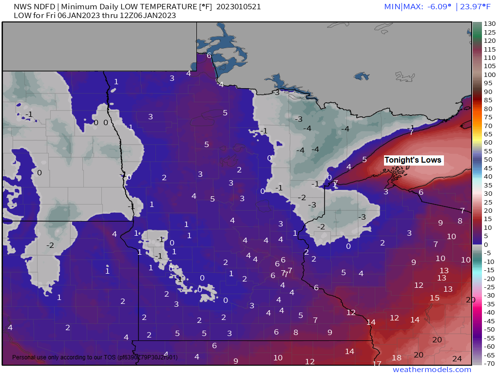
A chilly night ahead in the Northland but nothing out of the ordinary for early January, with low temperatures ranging from around 10 below zero to the single digits above zero, but winds should remain relatively light tonight.
There is a chance that we could see some areas of freezing fog develop in the Northland later this evening and continuing through early Friday afternoon with highs on Friday in the upper 10s to lower 20s.
Highs for this weekend will mainly be in the 20s which is near to slightly warmer than average for this time of year.
Updated Snow Stats for Duluth, Minnesota
Snowfall total to date for winter 2022-2023 (since Dec. 1, 2022) 50.1″
Normal snowfall to date: 21.0″
Departure: +29.1″ above normal
Percent of Normal Snowfall to date: 239% of normal
Note: Duluth averages 50.6″ of snow from December 1st through February 28th meaning that we’ve had almost as much snow here in December and in the first few days of January compared to what we average for the 3-month period from December-February. That is crazy!
Seasonal snowfall total (Since Oct. 1, 2022) 68.1″
Normal snowfall to date: 38.5″
Departure: +29.6″ above normal
Percent of Normal Snowfall to date: 177% of normal
HRRR model visibility forecast through 6 PM Friday
(Purple colors represent visibilities of a mile or less)

Areas of low clouds and freezing fog were found over parts of North Dakota and northwest/western Minnesota today.

Quite a range in temperatures across the region today, with single digits in parts of North Dakota into parts of far western and northeast Minnesota, to the 20s and 30s from eastern Minnesota into central/southern Wisconsin.

| Final Snowfall Reports from the January 3-4, 2023, Winter Storm Source: NWS Duluth, MN 3 NNW Mahtowa, MN: 14.9″ 3 N Pleasant Valley, MN: 14.5″ Barnum, MN: 14.0″ 3 ENE Holyoke, MN: 13.9″ 1 W Solon Springs, WI: 13.0″ 2 SSW Barnum, MN: 12.5″ 2 N Moquah, WI: 11.5″ 7 WSW McGrath, MN: 11.5″ Ashland, WI: 11.3″ 1 WSW Maple, WI: 11.1″ Mason, WI: 11.0″ 2 SW Moose Lake, MN: 11.0″ 1 SSE Hawthorne, WI: 10.7″ 5 S Herbster, WI: 10.3″ 2 NW Fond du Lac, MN: 10.0″ 3 W Bayfield, WI: 9.5″ Gile, WI: 9.5″ 2 WSW Superior, WI: 9.3″ 3 WNW Clam Lake, WI: 9.2″ 3 ENE Wright, MN: 9.0″ Minong, WI: 9.0″ 1 NE Sturgeon Lake, MN: 8.5″ 2 ESE Duluth, MN: 8.5″ 3 N Amnicon Falls State Park, WI: 8.5″ 1 SSW Grantsburg, WI: 8.3″ 4 E Hayward, WI: 8.2″ 2 ESE Shell Lake, WI: 8.2″ 3 E Sarona, WI: 8.0″ 6 SW Webb Lake, WI: 7.7″ Washburn, WI: 7.6″ 2 N Pillager, MN: 7.3″ 2 NE Cloquet, MN: 7.0″ 1 NW Hurley, WI: 7.0″ 1 NW Island Lake, MN: 6.6″ 6 NE Hertel, WI: 6.6″ 5 NE Rice Lake, MN: 6.4″ 1 WSW Lester Park, MN: 6.0″ 2 SW Two Harbors, MN: 6.0″ Glory, MN: 6.0″ 1 SSE Cornucopia, WI: 5.9″ 4 WNW Two Harbors, MN: 5.8″ Duluth, MN: 5.2″ (Official total at the National Weather Service) 3 E Sand Bay, WI: 4.7″ 1 SW Swan River, MN: 2.3″ |
Observed snowfall over the past 48 hours.

My final forecast for this past winter storm
Overall, not too bad as I did have an area of snow totals up to 12″ just south of Duluth, but the northern extent of snow accumulations ended up slightly further south vs. where I forecasted that northern cutoff zone to be.

The weather pattern looks pretty quiet across the Northland into early next week, but a more active pattern may return mid to late next week.
A trough (outlined in black on the map) is forecast to move east or southeast out of the Rockies for the middle to end of next week, and that trough may extend far enough north to bring a little snow to the Northland later next week.

Here’s the evolution of that aforementioned trough coming out of the Rockies (blue colors) mid to late week per Euro ensemble model.
500mb forecast valid January 11-13, 2023.

Thanks for reading!
Tim
Leave a Reply