5:06 PM Sunday, January 8, 2023
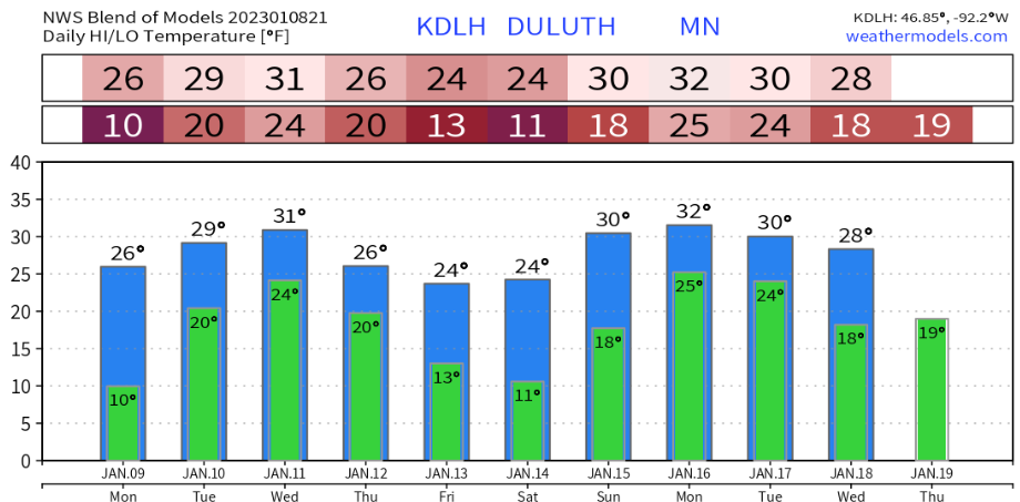
Looks like temperatures will remain above zero in Duluth through mid-January (possibly all the way through the 19th or even beyond) so I could see this going one of two ways. Either we make up for the lack of cold in January by having a brutally cold February, or the arctic air is pretty much over with for the rest of this winter, and with a lack of any sustained arctic air, Lake Superior won’t be making any ice or very little ice for the next 1 to 2 weeks.
The record for fewest number of subzero nights in January in Duluth was set in 2006 with 1 subzero night. Second fewest is 3 nights set in multiple years (1932, 1898, 1891 and 1889) And when looking at what February produced in terms of the number of subzero nights in those aforementioned years, we see that 2 of them went on to produce above average number of subzero nights in February, while 3 of them had near to below average number of subzero nights in February.
Duluth averages 15 subzero nights in January, and 11 subzero nights in February (1874-2022 climate period)
Air quality has been less than stellar the last few days over much of Minnesota due to fairly light winds with not much change in the overall weather pattern, in other words the pattern is stagnant which has led to some moderate air quality issues (yellow) over much of the state.
Areas of freezing fog at night giving way to hazy skies during the late morning and afternoon have been the norm the last few days, and this will probably continue at least into Monday.

There are a number of GEFS members showing at least 2″ of snow in all or parts of the Northland for the middle of the week.
GEFS 20-member snowfall accumulation forecast (10:1 ratio) through 6 PM Thursday, January 12, 2023.
Blue colors represent 2″+ snow totals.

The EPS (euro ensemble) model also shows some snow but not nearly as widespread or as much snow as the GEFS model is showing for the middle of the week, with very low probabilities for snow totals of more than 3 inches at the moment.

Here’s a look at the NWS Blend of Models snowfall forecast through 6 PM Thursday.
Highest snow amounts for the midweek period could setup along the North Shore of Lake Superior in northeast Minnesota where some lake enhanced snow is possible due to east-southeast winds crossing the wide-open lake.

We’ve seen quite a flip in the temperature pattern as of late across the Lower 48.
Last 14 days saw well below average temperature anomalies (blue and purple colors on image) over much of the Lower 48.

But fast forward to the last 7 days, and temperature anomalies were well above average (red and white colors on image) over a large portion of the Lower 48.
Temperature Anomalies in the Northland for January 2023 (thru the 7th)
Duluth, MN: +7.6 degrees above average
International Falls, MN: +7.4 degrees above average
Hibbing, MN: +7.0 degrees above average
Ashland, WI: +6.5 degrees above average
Brainerd, MN: +4.9 degrees above average

Thanks for reading!
Tim
Leave a Reply