5:31 PM Thursday, January 12, 2023
The next several days look dry in northeast Minnesota and northwest Wisconsin, but as we get into next week the pattern becomes much more active as will see multiple low pressure systems moving ENE out of the Rockies.
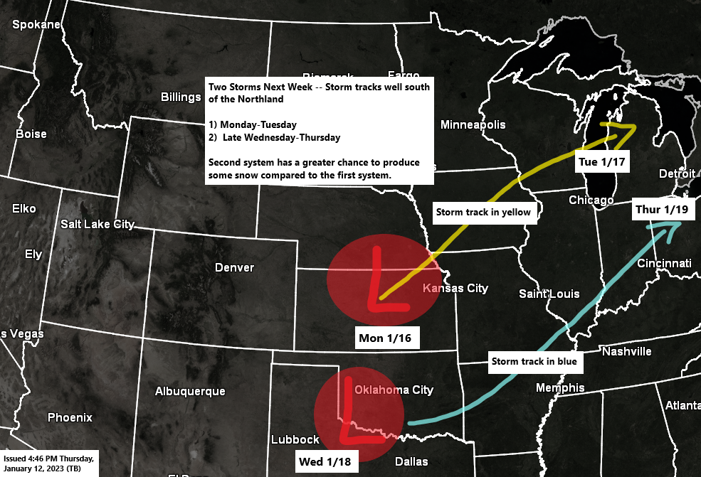
The storm track sets up pretty far to the south next week which lessens the chance for a more significant winter weather event hitting the Northland, but some light snow is possible especially with a second system mid to late next week.
A lead system next Monday looks like a warm system with mainly rain and perhaps a narrow band of mostly minor wet snow accumulations with that one, but the majority of this precipitation with the system early next week looks like it will stay south of the Northland.
A bit of a pattern change today as we’ve seen an increase in winds and better air quality compared to the last few days. Temperatures are also running considerably cooler compared to the last few days with temperatures mostly in the mid 10s to mid 20s in the Northland this afternoon, but this is where we should be for this time of year.
North winds have been on the gusty side today due to a tight pressure gradient between strong high pressure over the eastern Dakotas and an area of low pressure over western Pennsylvania. It won’t be nearly as windy on Friday.
Highs in the low to mid 20s are expected Friday, warming to the upper 20s to low 30s Saturday, and then in the 30s to lower 40s Sunday.
Note — If temperatures remain above zero in Duluth tonight, then the wait continues for our first subzero temperature of January 2023, and if we don’t drop below zero tonight, then will likely have to wait at least another week (if not longer) for the next chance for subzero temperatures. The record for fewest number of subzero nights for January in Duluth is 1 set in 2006.

It’s been an active day for severe weather across the southeast U.S. into the southern Ohio Valley with nearly 120 filtered storm reports, including 25 preliminary tornado reports (24 in Alabama, and 1 in Kentucky)

It’s been a warm January up to this point, and this trend of warmer than average temperatures will likely continue into next week, but some colder trends continue to show up on the computer models later this month, but it likely won’t be enough to get rid of these huge temperature anomalies we have so far this month.
Average temperature and departure from normal for January 2023 (thru the 11th)
Ashland, WI: 22.7 F, +7.9 degrees above average
Duluth, MN: 21.0 F, +9.1 degrees above average
Brainerd, MN: 18.0 F, +6.7 degrees above average
Hibbing, MN: 16.9 F, +10.0 degrees above average
International Falls, MN: 16.1 F, +10.5 degrees above average
Warmest January on record
Ashland: 25.9 F set in 2006.
Brainerd: 25.2 F set in 2006.
Duluth: 23.7 F set in 2006.
Hibbing: 21.0 F set in 2006.
International Falls: 18.8 F set in 2006.
Lower 48 Temperature Anomaly for January 2023

Computer models are in disagreement when it comes to the temperature forecast for the January 21-26 time frame with the Euro ensemble model considerably warmer compared to the GEFS model.

GEFS model temperature anomaly trend for January 21-26, 2023.
Blues: Below average temperatures
Orange and Red: Above average temperatures

Thanks for reading!
Tim
Leave a Reply