5:52 PM Friday, January 13, 2023
We’ve seen some changes in model data today regarding the storm track for early next week.
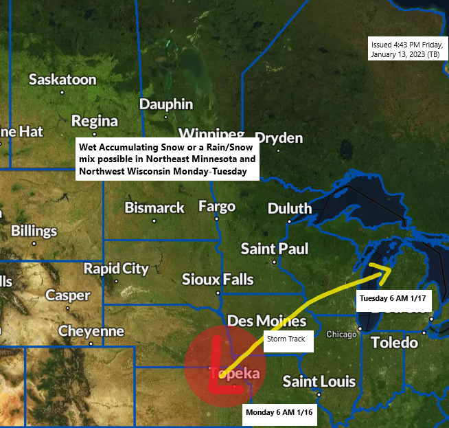
An area of low pressure is still forecast to lift northeast out of the central Plains on Monday, but now it looks like this low may track far enough to the north to bring a little more precipitation to much of the Northland compared to what it looked like 24 hours ago.
Temperatures with this system for early next week still look pretty warm, so if we end up getting snow, expect the snow to be wet and heavy, but fortunately this still doesn’t look like this would be a major snow event in our area, but even a couple inches of wet heavy snow is enough.
There is also a risk for some rain or a wintry mix of precipitation especially in eastern Minnesota and northwest Wisconsin on Monday.
An area of up to 2 inches of wet snow is possible early next week from the Brainerd Lakes into eastern Minnesota, the Twin Ports and North Shore, into parts of northwest Wisconsin.
Lower chances for up to 2 inches of snow farther north across northern Minnesota, and also for southeast portions of northwest Wisconsin.
Note — Snow totals could increase or decrease a bit over the next few days, and the area at greatest risk for snow could shift around a bit as well.

500mb low/trough ejects NE out of the western High Plains late this weekend and as this system passes over the upper Midwest Monday and Tuesday, we could see the upper low close off for a time, but this system will keep moving and not stall out like we’ve seen with past systems this winter.
Here’s the 500mb forecast valid 6 PM Sunday through 6 PM Tuesday, January 15-17, 2023.

Not one member of the GEFS model (12z run) shows snow totals of at least 2 inches in Duluth early next week, while the Euro ensemble model shows 76% of members with at least 2 inches of snow early next week, and this is up from 38% of members from 24 hours ago.
Here’s the 12z GEFS model 20-member snowfall forecast (10:1 ratio)
Blue colors=2″ snow totals

A chunk of arctic air covered eastern Canada (parts of Quebec and eastern Ontario) today with temperatures in the single digits below to around 20 below zero.
Still no signs of any arctic air affecting the Northland through much of next week (possibly even beyond that time)

The pattern is pretty amplified right now with strong troughs over the eastern U.S., and over the far western U.S., while a big ridge was found in between the troughs today. Note — The trough over the eastern U.S. is taking on a negative tilt this afternoon.

Warming trend kicks in on Saturday with highs in the upper 20s to lower 30s in the Northland, followed by even warmer temperatures Sunday and Monday with highs in the 30s, with a few 40s even possible especially on Sunday.
Note — Areas of fog are possible across the Northland tonight into Saturday morning.

Thanks for reading!
Tim
Leave a Reply