6:02 PM Friday, January 27, 2023
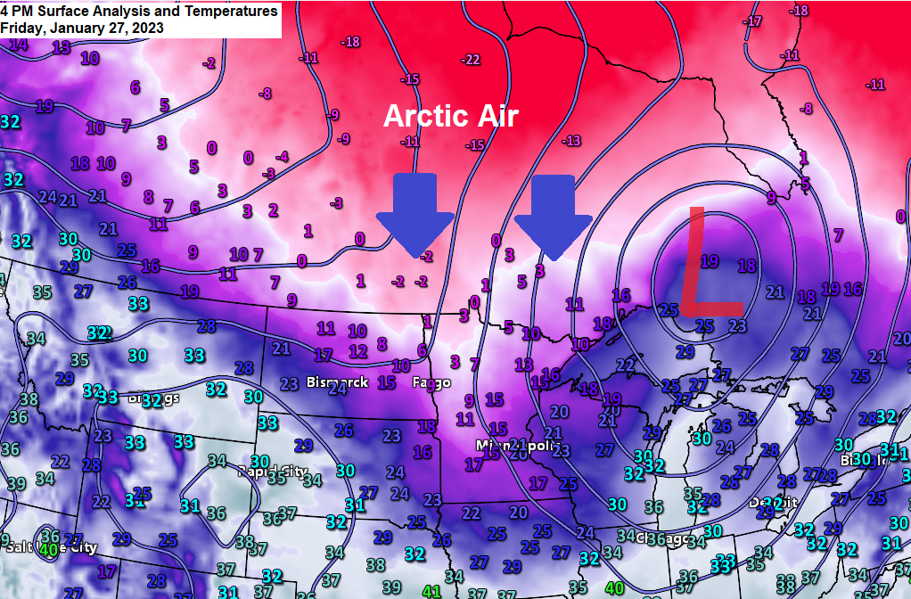
The snow is done and now it’s all about the cold as the pattern has become much more favorable for arctic air masses to affect the Northland this weekend into most of next week.
Highs in the single digits below to single digits above zero are likely in the Northland through early next week with lows from this weekend through mid/late next week in the -10s and -20s with a few -30s possible in the traditional cold spots.
Note — Looks like we may put together a streak of about 7 consecutive nights with a subzero temperature in Duluth with this upcoming arctic blast. The arctic blast back in December had 9 nights in a row with a subzero temperature.
This upcoming cold blast may help to develop some ice on Lake Superior over the next week. Ice coverage on Lake Superior is running <5% as of January 26th. Normal ice coverage on Lake Superior in late January is 25%.
Updated Snow Stats for Duluth, Minnesota
Month to Date Snowfall Total: 17.2″
Normal Snowfall to Date: 14.8″
Departure from Normal: +2.4″ above normal
Percent of Normal: 116% of normal
Note — January 2023 will finish slightly above average (+0.4″) in snowfall in Duluth even if we don’t get any more snow the rest of this month as the normal snowfall in January is 16.8″.
Seasonal Snowfall Total to Date: 80.1″
Normal Seasonal Snowfall Total to Date: 50.4″
Departure from Normal: +29.7″ above normal
Percent of Normal: 159% of normal
500mb heights continue to lower while 850mb temperatures continue to trend colder as arctic air begins to push south out of Canada today in wake of the clipper system from earlier today.

Wind Chill Advisory for northern Minnesota from 9 PM this evening to Noon Saturday, and this will likely be the first of many wind chill headlines will see in our area over the next several days.
Wind chills as low as 30 below zero in the advisory area tonight through early Saturday afternoon.

Tonight’s Lows

Snowfall Reports from January 27, 2023
Source: National Weather Service Duluth, Minnesota
Note — A new daily snowfall record for January 27th was set today at International Falls with 6.8 inches of snow this broke the previous record snowfall of 4.7 inches set in 1993.
Snowfall ratio in Duluth today was 17:1 so a much drier/fluffier snow compared to recent snowfall events.
International Falls, MN: 6.8″
Embarrass, MN: 3.3″
Two Harbors, MN: 3.0″
2 E Celina, MN: 3.0″
4.3 SW Shell Lake, WI: 3.0″
5.7 ESE Cotton, MN: 2.8″
11.8 N Lutsen, MN: 2.7″
3 SW Lester Park, MN: 2.5″
Duluth, MN: 2.4″ (Official total at the NWS)
4.4 SSE Hayward, WI: 2.3″
1 E Ely, MN: 2.2″
7 N McGregor, MN: 2.2″
6 NE Hertel, WI: 2.1″
3 SSE Coleraine, MN: 2.1″
2 SW Two Harbors, MN: 2.0″
4.2 ENE Nisswa, MN: 2.0″
2 SW Moose Lake, MN: 1.8″
4.4 W Grand Marais, MN: 1.8″
Herbster, WI: 1.8″
1 NNW Marcell, MN: 1.8″
3 NNW Mahtowa, MN: 1.7″
3.7 WNW Superior, WI: 1.4″
Wrenshall, MN: 1.3″
1 SSE Cornucopia, WI: 1.3″
Duquette, MN: 1.2″
3 N Amnicon Falls State Park, WI: 1.1″
Spooner, WI: 1.0″
3 S Ashland, WI: 1.0″
1.2 W Solon Springs, WI: 1.0″
Gile, WI: 1.0″
Hurley, WI: 1.0″
Winter Storm late tonight into Saturday
Heads up if you have travel plans that take you to southern Minnesota, northern Iowa, southern Wisconsin, northern Nebraska or southern South Dakota over the next 24 hours as a winter storm will impact those aforementioned areas with significant amounts of snow and gusty winds.

18z HRRR model radar forecast through Midnight Saturday night.

Snowfall forecast thru 6 PM Saturday.

Thanks for reading!
Tim
Leave a Reply