4:37 PM Monday, January 30, 2023
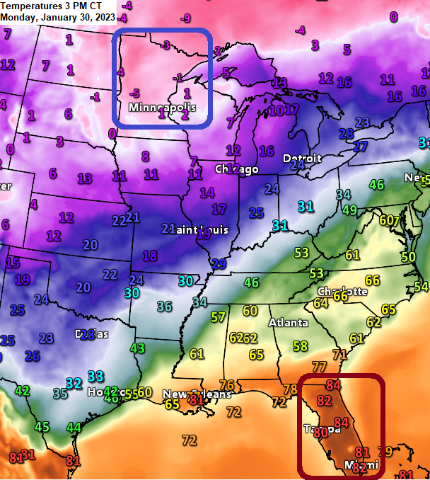
If you’re looking to escape the cold air, Florida looks like a good spot right about now with temperatures in the 80s this afternoon compared to temperatures in the single digits below zero to around zero in northern Minnesota and northwest Wisconsin.
Looks like we have about 4 or 5 more subzero nights ahead in Duluth this week. Coldest temperature so far in this arctic blast has been -18 degrees on January 29th, and this matches the lowest temperature we saw during the arctic blast back in mid-December.
Arctic air has helped to develop some ice over portions of Lake Superior the last few days, but ice coverage on Lake Superior is still running well below average for this time of year.

As of January 29, 2023 — Around 7% of Lake Superior was covered by ice. Average amount of Lake Superior covered by ice in late January is 25%.

Another night and another wind chill headline for all of northeast Minnesota and northwest Wisconsin with a Wind Chill Advisory in effect until 10 AM Tuesday. Wind chills as low as 30 to 35 below zero.

A weak system might produce a short period of fluffy snow in parts of the Northland Tuesday night-early Wednesday morning, but snowfall accumulations should remain under an inch.
18z NAM 3km model radar forecast valid 6 PM Tuesday to 6 AM Wednesday.

It’s all about the cold temperatures this week in northeast Minnesota and northwest Wisconsin.
Highs ranging from around zero to the single digits above zero Tuesday, Thursday and Friday, but on Wednesday will see highs jump into the teens.
Lows will be in the -10s and -20s tonight. Single digits below zero to the 10s below zero Tuesday night, and from the single digits above zero to the 10s below zero Wednesday night. Thursday night looks frigid with lows in the -10s, -20s and -30s as will see one last shot of arctic air push through the area.

A warmer temperature pattern sets up this weekend and this could carry over into much of next week with highs in the 20s to lower 30s, while temperatures at night stay well above zero.

Two minor snow events are possible in the Northland this weekend and early next week, but neither one look too impressive at the moment.
The setup in both looks very similar to each other with dual low-pressure systems (red L on maps) approaching from the west, but again this setup doesn’t look very favorable for a significant snow event.


Widespread winter weather alerts are in effect stretching from parts of the Southern Plains to the Ohio Valley.

Ice accumulations from freezing rain, freezing drizzle and sleet will be the main hazard with this system with light snowfall accumulations of around an inch or so.
NWS Ice Accumulation Forecast thru 12 PM Tuesday. Note, more ice accumulations are likely past 12 PM Tuesday.

18z HRRR model radar forecast through 12 PM Wednesday.
Freezing Rain and Sleet (purple)
Rain (green)

Thanks for reading!
Tim
Leave a Reply