5:36 PM Sunday, February 5, 2023
Some snow or a mixture of sleet, snow and possibly some patchy rain or freezing rain is expected in much of the Northland late Monday afternoon into Monday night but mostly light snow and or ice amounts are expected with this system with no major impacts to travel expected, but still expect some slippery roads and hazardous travel conditions for a time Monday evening/overnight.
Total snowfall accumulations of 1-2 inches are possible along the North Shore and over the Arrowhead Monday night with snow amounts of a trace to 1 inch possible in the rest of the Northland including Duluth.

Monday morning and early afternoon look dry across the Northland with chances for precipitation increasing from SW-NE later Monday afternoon after 2 PM.
For Duluth — Looks dry into mid-afternoon Monday with some snow or mixed precipitation possible after 4 PM Monday and then lingering through the evening.
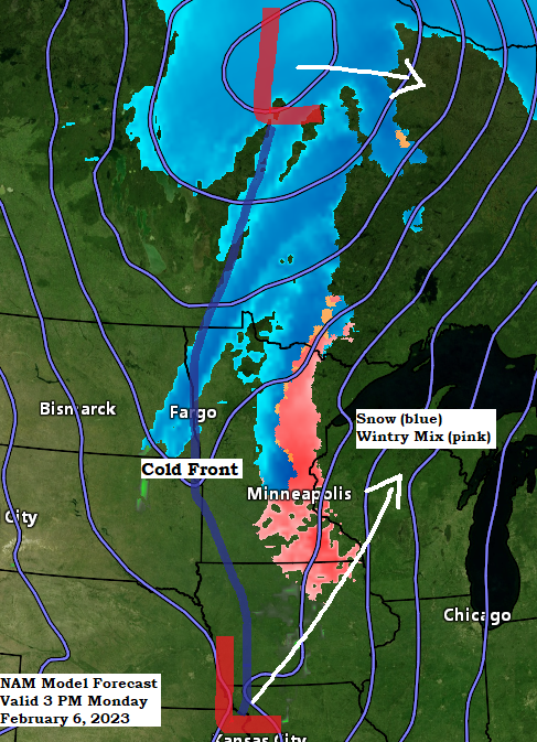
NAM 3km model radar forecast valid 12 PM Monday to 6 AM Tuesday.
Snow (blue)
Mix (pink/purple)

A light glaze of ice is possible (pink area) late Monday afternoon/night.

A short period of enhanced lift (yellow, orange and red colors on animation below) is still expected to lift quickly NE out of southern Minnesota late Monday afternoon, and this is when we should see most of the precipitation out of this system when this stronger lift passes over portions of the Northland late Monday afternoon into early Monday evening.
NAM model 700mb forecast valid 9 AM Monday to 9 PM Monday.

There is also a chance will see some weak instability develop with this system Monday afternoon/early Monday evening with elevated CAPE to around 150 j/kg possible (purple colors on animation below) over south-central/eastern Minnesota into west-central Wisconsin.
The combination of weak potential instability and an area of steep mid-level lapse rates around 7.0 c/km could lead to some heavier convective showers of snow or sleet over the aforementioned areas later in the day Monday.
NAM 3km model MUCAPE forecast valid 11 AM Monday to 9 PM Monday.

System which will impact the upper Midwest on Monday has been moving south/east across the western U.S. today but notice how some of the energy is diving SE across California and Nevada while additional energy is moving east across western Canada and the Northern Rockies today, in other words this system is sort of split with energy to the north and energy farther to the south.
Goes-16 water vapor loop from Sunday, February 5, 2023 (loop time ends 4:40 PM CT)

10-Day Temperature Forecast for Duluth, Minnesota.
Looks like will have several days with highs at or above freezing in Duluth this week into the middle of next week, with the coldest temperatures at night in the single digits above zero, so no additional subzero temperatures are expected in Duluth at least through February 15th the way it looks now.

Thanks for reading!
Tim
Leave a Reply