6:01 PM Thursday, February 23, 2023
- An active weather pattern continues.
- Daily snowfall record set at Duluth, Minnesota today with 6.2 inches of snow. The previous snowiest February 23rd on record was 3.9 inches set in 1893 or 130 years ago.
- 12.2 inches of snow in Duluth so far this month, this is right at the normal amount thru February 23rd.
- 92.3 inches of snow in Duluth for the season. This is +27.7 inches above normal snowfall to date.
- The next few days look pretty quiet in the Northland, but a weak disturbance zipping across the area could bring a skiff of snow Friday night.
- System early next week could bring freezing rain (ice accumulations) and snow to the Northland.
For the most part the forecast verified pretty well for the winter storm which impacted the Northland last night and today.
-Highest snow amounts were forecast to be over northwest Wisconsin and that’s right where they ended up.
-Lowest snow amounts were forecast to be across northern Minnesota into the Arrowhead, and well that did verify, but totals were also lower farther to the south in northeast Minnesota which ended up being a miss, at least when it comes to my forecast.
-Snow totals in Duluth verified nicely at least on top of the hill where official snow measurements are taken for Duluth. With the National Weather Service office in Duluth reporting 6.6 inches of snow thru 12 PM Thursday. My forecast was for a range between 4 and 7 inches of snow in Duluth (on top of the hill), but I was forecasting higher snow totals below the hill in Duluth, and so far, I haven’t seen any reports if totals reached at least 7 inches below the hill (my forecast was for 7 to 10 inches of snow below the hill in Duluth).
As is often the case with these snow events, the amount of snow your location received may have varied quite a bit from other locations across the area. As a weather enthusiast, I can tell you that no snow forecast will ever be 100% accurate, there will always end up being locations that end up with less snow than forecast, and other locations that get more snow than forecast, but if you can get the forecast snow amounts in the range that you are predicting, then I’d say you’re doing a good job!
Snowfall Totals from February 22-23, 2023
Source: National Weather Service Duluth, Minnesota
1 NE Benoit, WI: 26.0″
5 WSW Washburn, WI: 17.0″
4 S Cornucopia, WI: 16.0″
2 E Odanah, WI: 15.0″
3 E Sarona, WI: 12.4″
4 SSW Shell Lake, WI: 12.0″
4 NW Namekagon, WI: 10.8″
5 E Oliver, WI: 10.0″
Hawthorne, WI: 10.0″
4 SSW Webster, WI: 9.5″
1 SW Grantsburg, WI: 9.4″
5 W Pine Center, MN: 9.0″
5 S Herbster, WI: 9.0″
1 WSW Maple, WI: 8.4″
3 ENE Holyoke, MN: 8.0″
Hertel, WI: 8.0″
1 SE Malmo, MN: 7.8″
3 NNW Mahtowa, MN: 7.6″
1 N Fort Ripley, MN: 7.5″
Kettle River, MN: 7.0″
2 SSW Moose Lake, MN: 6.2″
1 NNE Cloquet, MN: 6.0″
8 SE Brainerd, MN: 6.0″
Gile, WI: 6.0″
6 SW Webb Lake, WI: 6.0″
1 W Solon Springs, WI: 5.9″
4 S Nisswa, MN: 3.8″
2 NNE Duluth, MN: 3.8″
2 SW Tamarack, MN: 3.0″
2 NW Two Harbors, MN: 1.5″
French River, MN: 1.0″
Palisade, MN: 1.0″
It’s going to be a very cold night across the area with low temperatures here in the Northland ranging from around 20 below zero to the single digits below zero.
More subzero temperatures are expected Friday night although not as cold as what will see tonight.
Temperatures on Friday will only climb into the teens for daytime highs (normal highs range from the mid 20s to 30 degrees in late February)
Highs Saturday will be in the mid-teens to mid 20s, and by Sunday will see a few 30s return to the Northland.

ICE & SNOW POTENTIAL EARLY NEXT WEEK
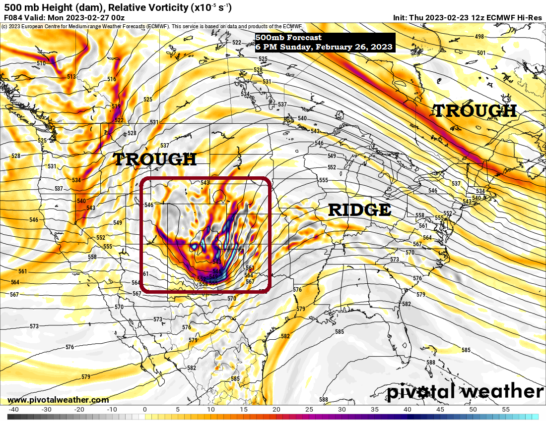
Trough reloads over the western U.S. the next few days with a system likely ejecting out of that trough moving quickly NE out of the southwest U.S. and through the Central Plains and Ohio Valley early next week. This system combined with some additional energy moving out of Canada could bring a wintry mess to northeast Minnesota and northwest Wisconsin early next week (late Sunday night-early Tuesday morning time frame).
Temperatures do look warmer with this system early next week, although surface temps are forecast to remain below freezing, but temperatures aloft are forecast to be >0C which increases the risk to get some freezing rain in parts of the Northland. Some snow is also expected with this system early next week. Stay tuned.

The majority of the GEFS ensemble members show precipitation impacting the Northland next Monday.
Snow (blue)
Rain (green)
Winty Mix (pink/purple)

Here’s an early look at potential ice accumulations for next Monday.
European model is pretty aggressive right now with ice accumulations in parts of central/eastern Minnesota into western/central Wisconsin.

NBM (National Blend of Models) is also showing some icing potential for next Monday but not nearly as significant as the Euro model at the moment.

SEVERE THUNDERSTORMS POSSIBLE SUNDAY
There is a risk for severe thunderstorms Sunday and Sunday night across portions of the Central Plains stretching from central and eastern Kansas south through much of Oklahoma and into northern Texas. Damaging winds, large hail and a few tornadoes are possible in the aforementioned areas late this weekend.

Major temperature contrast continues today.
80-degree temperatures as far north as Washington D.C. today.
Temperatures in the single digits and teens below zero from Montana and Wyoming to the Dakotas.

Numerous record high temperatures broken or tied once again today from the Ohio Valley to the southeast/eastern U.S.

Thanks for reading!
Tim
Leave a Reply