6:27 PM Wednesday, February 22, 2023
- Winter storm continues tonight and Thursday with snow, gusty winds and blowing snow. Highest snow totals are expected in northwest Wisconsin including the South Shore with lesser amounts of snow across northern Minnesota into the Arrowhead.
- Occasional whiteout conditions are likely tonight into at least Thursday morning near Lake Superior (highest chances along the South Shore)
- A break in the snow Thursday night and Friday, but a quick moving system could bring a light snow event to some parts of the Northland Friday night/Saturday morning.
- A larger system could impact the Northland early next week with snow, sleet and freezing rain (timing is from Monday to early Tuesday) This system is still several days out, and it’s a complex setup with possible phasing between a northern system and a southern system, so there is uncertainty on how all of this will play out, but figured I’d give everyone a heads up on the potential for another system which could impact the Northland early next week.
There’s been very little change in model guidance regarding snowfall totals across the Northland through Thursday afternoon, and for that reason I won’t be making any changes to my snowfall forecast which I made on Monday for this event.
With that said, I do have a few concerns, mostly with the amount of dry air present across northern Minnesota, and this dry air could eat away at some of the snow which could lead to lower snow totals compared to what I’m forecasting.
Forecasters give snowfall ranges for a reason, so keep that in mind. Your location could end up on the lower end of the forecasted range, or the higher end, or somewhere in the middle.
For Duluth — Snowfall storm totals by late Thursday afternoon ranging from 4 to 7 inches on top of the hill (Hermantown/Proctor areas) to 7 to 10 inches below the hill. Localized snowfall storm totals of up to 12 inches are possible especially in the Morgan Park, Gary New-Duluth and Fond du Lac areas.

A favorable wind direction will continue to be in place tonight for more lake effect/enhanced snowfall especially on the south side of Duluth, and also affecting the city of Superior. This lake effect/enhanced snow will extend as far south as Wrenshall, Holyoke and Patzau. Winds will shift from the NE to more of a NNE direction by early Thursday morning, and then to the N during the day Thursday which will end the threat for lake effect snow in the Twin Ports area.

Lake effect snow continues near Lake Superior (mainly along the South Shore) this evening while snow from the actual system over the Midwest spreads slowly north across the Northland tonight.
Snow continues on Thursday but should taper off from west to east during the mid to late afternoon.
Heaviest snowfall late tonight through most of Thursday morning.
18z NAM 3km model radar forecast through Midnight tomorrow night.

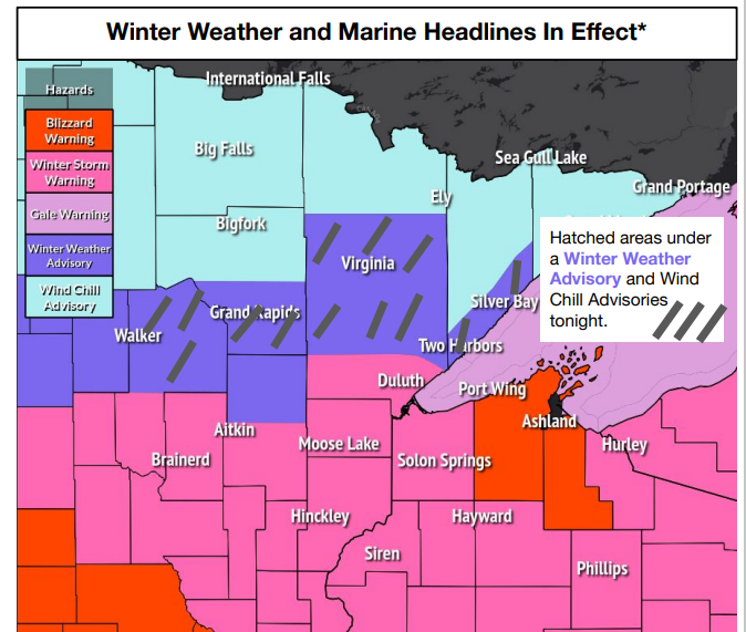
Wind Chill headlines to the north while further to the south there are winter weather advisories, winter storm warnings and a blizzard warning in effect through Thursday.
-Travel could be very difficult to impossible in the blizzard warning. The blizzard conditions are most likely within 10 miles of Lake Superior. This area includes portions of Wisconsin Highways 13, 112, 118 and portions of US Highways 2 and 63 near Ashland.
-Travel could be very difficult in the winter storm warning. Patchy blowing snow could significantly reduce visibility.
For Duluth – Winter Storm Warning in effect until 6 PM Thursday.

Northeast winds will continue to crank near Lake Superior tonight into Thursday morning with wind gusts of 25 to 45 mph, to possibly as high as 55 mph along the South Shore of Lake Superior.
Winds will diminish near Lake Superior from west to east Thursday afternoon.
HRRR model wind gust forecast through 6 PM Thursday.

It’s been all about the lake effect snow today ahead of the system snow which arrives tonight.
An arctic air mass consisting of 850mb temperatures of -16 to -18C moving down a wide-open Lake Superior on northeasterly winds has led to two dominant bands of lake effect snow today.
One of those bands impacted Ashland and nearby areas with reports of 5 to as much as 13 inchs of snow today — See list below.
1 NE Benoit, WI: 13.0″
2 W Benoit, WI: 9.0″
Ashland, WI: 7.0″
2 E Odanah, WI: 5.0″
4 WNW Washburn, WI: 3.0″
A second band of lake effect snow has been impacting portions of northwest Douglas County including the city of Superior, south to Oliver and Patzau, into far eastern Carlton County around the Wrenshall area with a couple inches of snow reported underneath that lake snow band today.

You can see the lake effect clouds earlier today over Lake Superior. Note the movement from generally NE-SW, while higher level clouds were moving off to the NE.
Goes-16 visible satellite loop from Wednesday, February 22, 2023 (loop time 8:21 AM to 9:36 AM CT)

A large low-pressure system was centered just northeast of Kansas City at 3 PM today. This low will be tracking to the northeast passing near Chicago around daybreak on Thursday, then this low will move across far southern lower Michigan during the day Thursday.

North of the surface low we’re seeing snow, sleet and freezing rain today, with an ice storm impacting parts of southern Wisconsin, southwest lower Michigan and far northern Illinois with reports of a quarter to half inch of ice accretion today in southern Wisconsin.

Helping fuel this storm is this major temperature contrast today.
Temperatures in the single digits below zero in North Dakota to the 70s in southern Indiana.

Numerous locations from the Ohio Valley to the southeast U.S. are setting or tying record high temperatures today.

A large trough covering the western U.S. today while pieces of energy break off that trough while they lift ENE through the Plains, upper Midwest and Great Lakes.
Water vapor loop from Wednesday, February 22, 2023.


Strong divergence/enhanced precipitation taking place today across parts of the upper Midwest due to two jet streaks, one off to the NE over eastern Canada and the other off to the SW across the southwest U.S. into the Central Plains.

Thanks for reading!
Tim
Leave a Reply