6:18 PM Tuesday, February 21, 2023
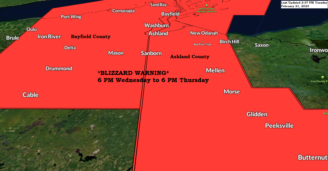
BLIZZARD WARNING
-Blizzard Warning in effect from 6 PM Wednesday to 6 PM Thursday including Bayfield and Ashland Counties in northwest Wisconsin along the South Shore of Lake Superior. Some cities included in the blizzard warning — Port Wing, Iron River, Cornucopia, Bayfield, Washburn, Ashland and Odanah.
-Travel could be very difficult to impossible. Widespread blowing snow could significantly reduce visibility.
-Travel should be restricted to only emergencies Wednesday night into Thursday.

Here are some of the highways in Bayfield and Ashland Counties which may be impacted by blizzard conditions Wednesday evening into Thursday afternoon.
*63
*13
*2

Here’s a look at all the winter weather headlines that are in effect across the Northland through Thursday.
Wind chill advisories to the north, while farther to the south we have winter storm warnings, advisories and a blizzard warning.
For Duluth — Winter Storm Warning in effect from 6 PM Wednesday to 6 PM Thursday.

LAKESHORE FLOODING POSSIBLE
Lakeshore Flood Watch in effect from Wednesday afternoon through Thursday afternoon for Southern St. Louis County near Lake Superior.
*Lakeshore flooding possible along Lake Superior shorelines.
*Shoreline erosion may occur.
*Roads may be closed.
*Low lying property including homes, businesses, and some critical infrastructure may be inundated.

I don’t see any reason to make any changes to my snowfall forecast based on pretty good model consistency throughout the day today but like with every single winter system there is always that possibility will see a last-minute shift in model guidance, so I’ll continue to watch the model trends tonight and tomorrow and adjust my forecast if need be.
For Duluth — A range in snowfall amounts from 4 to 7 inches on top of the hill, to possibly as much as 10 inches below the hill by Thursday evening. Areas of blowing and drifting snow are likely in the Twin Ports Wednesday into Thursday morning.
Note — Duluth still has a snowfall deficit of -5.4 inches this month, so will see if this next system can eliminate most if not all of that defect that we currently have.

LAKE EFFECT SNOW POTENTIAL
With winds coming out of the NE this does increase the chances of lake effect snow Wednesday into early Thursday, mostly over southern portions of Duluth including locations such as West Duluth, Smithville, Riverside, Morgan Park, Gary, New Duluth, Fond du Lac, and also in far northwest Wisconsin including Superior and Oliver.

STRONG WINDS NEAR LAKE SUPERIOR
Winds will begin to increase out of the north late tonight with wind gusts of 10 to 20 mph.
Winds become northeasterly during the day Wednesday and will remain out of the northeast through Thursday morning with winds increasing to 25 to 40 mph with gusts to 50 mph possible especially along the South Shore of Lake Superior. The strongest winds are expected from Wednesday afternoon/evening through Thursday morning.
Winds diminish from west to east near Lake Superior Thursday afternoon.
NAM 3km model wind gust forecast valid Midnight tonight to 3 PM Thursday.

TIMING OF THE SNOW
Tonight: Some light snow mostly over southern portions of the Northland impacting east central Minnesota and northwest Wisconsin.
Wednesday: A little light snow possible during the day once again affecting mainly east-central Minnesota and northwest Wisconsin. Dry in northern Minnesota and Arrowhead.
Wednesday night: Snow spreads northward eventually covering most of the Northland. Heaviest snowfall south, lightest snow across northern areas
Thursday: Snow continues during the day but tapers off from west to east during the afternoon/evening.
Note: Lake effect snow showers should develop late tonight/Wednesday morning along parts of the South Shore of Lake Superior, and some of this lake effect snow could move farther west impacting parts of Superior and Duluth during the day Wednesday into Wednesday night. There is very little ice covering Lake Superior this winter and this combined with plenty of cold air moving over the open waters should help develop a few lake effect snow bands Wednesday into Thursday. Locations such as West End, West Duluth, Riverside, Morgan Park, Oliver and Fond du Lac could get some lake effect snow based on how the winds setup Wednesday into early Thursday morning.
NAM 3km model radar forecast through Midnight Friday.

A big-time clash in air masses today with 850mb temperatures as low as -36C around Hudson Bay Canada to as warm as +20C over parts of Texas today.

Pretty crazy to see the expansiveness of this week’s system by the widespread nature of all the different weather alerts that are in effect.

A look at temperatures from late Tuesday afternoon.
Take your pick!
Temps around zero in parts of North Dakota and northwest Minnesota to the 80s and lower 90s in parts of Texas late today.

| Final Snowfall Reports from Monday, February 20, 2023 Source: National Weather Service Duluth, Minnesota Silver Bay, MN: 14.5″ 1 W Silver Bay, MN: 12.3″ 3 NE Tofte, MN: 10.0″ Gile, WI: 9.0″ 3 WSW Lutsen, MN: 8.1″ 8 NNW Bovey, MN: 8.0″ 8 W Hovland, MN: 8.0″ 3 S Cornucopia, WI: 7.5″ 1 NW Chisholm, MN: 7.5″ 3 SW Bayfield, WI: 7.1″ 2 ENE Cherry, MN: 7.0″ 4 NNE Grand Marais, MN: 6.8″ 7 NNE Wales, MN: 6.0″ 2 SSW Ely, MN: 5.8″ 4 S Tower, MN: 5.2″ Embarrass, MN: 5.0″ Two Harbors, MN: 5.0″ Cotton, MN: 5.0″ Hurley, WI: 5.0″ 7 SSW Grand Rapids, MN: 4.5″ 3 SSE Coleraine, MN: 4.2″ 2 E Celina, MN: 4.0″ Cass Lake, MN: 3.8″ 1 N Washburn, WI: 3.5″ Herbster, WI: 2.8″ Duluth, MN: 2.6″ (Official total at the NWS) 5 SSE Libby, MN: 2.3″ 3 SW Ashland, WI: 2.0″ 2 ENE Superior, WI: 2.0″ Wrenshall, MN: 1.5″ 3 WSW Cloquet, MN: 1.4″ 4 ESE Moose Lake, MN: 1.3″ 1 N Solon Springs, WI: 1.3″ |
Thanks for reading!
Tim
Leave a Reply