5:08 PM Thursday, March 2, 2023
- Cold front passes through the Northland Friday but no precipitation with this front.
- Dry weather continues Saturday and most of the day Sunday.
- Milder temperatures the next few days with highs in the mid 30s to around 40 Friday, Saturday and Sunday.
- Snow chances return Sunday evening-Monday but there is uncertainty on snow amounts with this system.
- Seasonal snowfall total for 2022-2023 is approaching 100 inches at Duluth with 99.5 inches of snow so far this season, this is +30.9 inches above normal snowfall to date. The record seasonal snowfall total is 135.4 inches which was set in 1995-96. Duluth is 35.9 inches shy of tying that record from 1995-96.
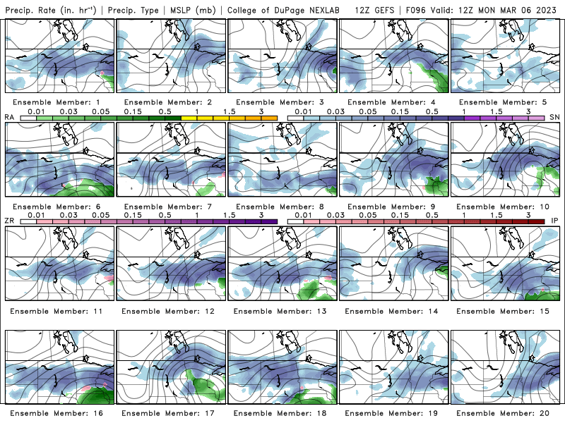
All 20 members of the GEFS model show at least some precipitation (mostly snow) impacting the Northland during the Sunday evening-Monday time frame.
Here’s the GEFS model precipitation type forecast valid for 7 AM Monday, March 6, 2023.
Snow (blue)
Rain (green)

Euro ensemble model probabilities for >3 inches of snow for early next week.

A cold early March morning in the Northland.
Low temperature reports from Thursday morning, March 2, 2023
Source: National Weather Service Duluth, Minnesota
Embarrass, MN: -17
2 S Tower, MN: -16
2 E Celina, MN: -16
Brimson, MN: -16
International Falls, MN: -15
Hibbing, MN: -15
Floodwood, MN: -14
Eveleth, MN: -13
Ely, MN: -11
Orr, MN: -11
Cook, MN: -11
Longville, MN: -11
Walker, MN: -10
Duluth, MN: -8
Another strong area of low-pressure will lift northeast out of northern Texas tonight reaching western New York by around daybreak on Saturday. This system will track well SE of the Northland with no impacts on our local area.
Severe thunderstorms are exploding late today over parts of Oklahoma and Texas out ahead of this deepening low-pressure system today.
Goes-16 sandwich satellite loop from Thursday, March 2, 2023 (loop time ends 4:11 PM CT)

Goes-16 water vapor loop from Thursday, March 2, 2023 (loop time ends 4:11 PM CT)

Tornado and Severe Thunderstorm Watches in effect through this evening for parts of Texas, Oklahoma and Arkansas.

Here’s a look at the strong to severe thunderstorms erupting over parts of north-central Texas into far southern Oklahoma late this afternoon.

The potential for severe thunderstorms continues Friday but for areas farther NE compared to where the risk is today/tonight.
Numerous severe thunderstorms are possible in the enhanced risk area, with scattered to isolated severe thunderstorms possible in the slight and marginal risk areas.

This next storm will also have a wintry side with heavy snow and mixed precipitation in the colder air north of the low-pressure track.

A swath of about 4 to 8 inches of snow is possible Friday-early Saturday from parts of central and northeast Illinois into parts of lower Michigan.

Thanks for reading!
Tim
Leave a Reply