6:16 PM Friday, March 3, 2023
- A pleasant late winter weekend ahead in the Northland with highs Saturday in the 30s to lower 40s.
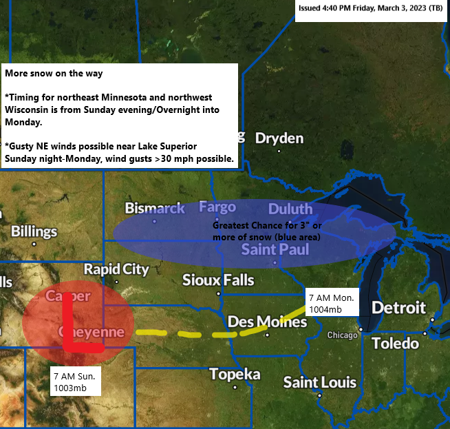
- The weather during the day Sunday doesn’t look too bad either, but the weather goes downhill again starting Sunday evening lingering into Monday with a potential for a few to several inches of snow in much of the Northland.
- Strong northeast winds are possible again near Lake Superior late Sunday into Monday. Wind gusts could top 30 mph. Patchy blowing snow is possible due to the gusty winds early next week.
- Still some uncertainty on snow amounts with this next system early next week but there is a chance for advisory level to perhaps warning level snow totals in some parts of the Northland, most likely from east-central Minnesota into northern Wisconsin and also for areas near Lake Superior with a lower chance across northern Minnesota.
- Snow that accumulates Sunday night and Monday could be a little wetter compared to the snow that fell with the system on Wednesday due to temperatures both at the surface and aloft being slightly warmer with this next system.
- 31/50 Euro ensemble (EPS) model members forecast at least 4″ of snow in Duluth between Sunday night-early Tuesday morning, this is up from just 15 members from Thursday. Or an increase from 30% on Thursday to 62% today. Max snow amount for Duluth is 11″ but the low-end amount is 0″.
- 30-inch snow depth at the National Weather Service in Duluth on March 3rd, 2023. A little melting will probably occur this weekend before we possibly add more snow on top of what’s already on the ground.
Currently it looks like will see some snow spread northeast into parts of the Northland starting Sunday evening (timing of this could change)
18z NAM 3km model radar forecast valid from 3 PM Sunday to Midnight Sunday night.

Northeast winds will increase near Lake Superior Sunday afternoon but will really ramp up late Sunday night into Monday, this is when we could see wind gusts exceeding 30 mph.
Euro model wind gust forecast valid 6 PM Sunday to 12 AM Tuesday.

Strong ridging returns to northeast Canada and the Hudson Bay region next week while troughing continues across the Rockies.
What happens from the middle of next week into next weekend is highly uncertain as there are many moving parts, but there is at least some potential for a storm to develop somewhere from the Plains, Great Lakes to the east coast sometime later next week.

1, 2, 3 storms as an active weather pattern continues today.

Here’s an animation of the above image.
Goes-16 visible satellite loop ending 12 PM CT, Friday, March 3, 2023.

A powerful area of low pressure continues to lift northeast across the Ohio Valley late this afternoon.

New all-time low-pressure records were set today across the Lower Ohio River Valley today.

Heavy rain and some flooding along with some severe thunderstorms occurring today south of the low, while heavy wet snow along with several instances of thundersnow were occurring northwest of the surface low today from central Illinois to northern Indiana to southern lower Michigan.

Thanks for reading!
Tim
Leave a Reply