5:44 PM Friday, March 10, 2023
A long duration snow event is likely in the Northland this weekend.
- Snow spreads east across the Northland on Saturday, beginning first in western areas during the morning, and then reaching eastern Minnesota, the Twin Ports, North Shore, Arrowhead and northwest Wisconsin Saturday afternoon.
- Snow continues Saturday night into Sunday, but a dry slot could move through a portion of the Northland for a few hours Sunday morning which would cause a lull in the snowfall for areas that get into that dry slot. Computer models differ with the low placement on Sunday which will affect how far north the dry slot will get.
- Will finally see the snow taper off in the Northland from west to east Sunday night/early Monday morning.
- At the very least we are looking at widespread snowfall totals of up to 6 inches over the entire Northland by Sunday evening, but there will be pockets of higher snow amounts which could get close to or even exceed a foot, this is especially true along the North Shore of Lake Superior where the setup is pretty favorable for lake/terrain enhanced snow Saturday afternoon into Sunday morning, about the only limiting factor would be the temperatures at 5000 feet (850mb) which look a little marginal in that -8 to -11 C range through Sunday morning.
- After last night’s snow event, Duluth is now 31.5 inches away from tying the seasonal snowfall record of 135.4 inches set in 1995-96.
What could go wrong with my snowfall forecast
Lighter snowfall intensities leading to minimal accumulations especially Saturday afternoon/early evening, and again during the day Sunday. That March sun angle is strong, so even with the sun not being out Saturday afternoon and Sunday afternoon, there’s still enough solar radiation getting through the clouds which could make it difficult for the snow to accumulate, but if snowfall intensities are heavy enough, then none of this will matter at all.
Here’s my updated snowfall forecast for this weekend (through 10 PM Sunday)
For Duluth: 8 to 11 inches of snow with 11 to 16 inches of snow favoring the far north/northeast portions of the city.
Note — I just realized I forgot to put the inch icon (“) in one of the 8-11 zones, sorry, it’s been a long winter.
Adjustments to my forecast are possible over the next 24 hours.


TIMING OF THE SNOW
As alluded to above, will see snow spread into western portions of the Northland Saturday morning (around or after daybreak) and there is also a chance for a few lake effect snow showers late tonight/Saturday morning along the North Shore of Lake Superior but little if any snow accumulation is expected.
Snow spreads east reaching northeast/eastern Minnesota and northwest Wisconsin Saturday afternoon.
Snow tapers off from NW-SE Sunday night, but some lingering lake effect snow showers are expected to continue into Monday morning along the South Shore of Lake Superior.
For Duluth — Snow develops during the day Saturday (between 11 AM and 1 PM) with snow possibly continuing for roughly 30 to 33 hours or so before the snow wraps up Sunday night.
Euro model radar forecast valid 6 AM Saturday to 7 AM Monday.

East winds with gusts of 25 to 45 mph are expected along the North Shore of Lake Superior Saturday afternoon/night, with another period of gusty winds this time out of the north possible Sunday afternoon/evening.
Areas of blowing snow are likely near Lake Superior due to the gusty winds Saturday and Sunday.
Euro model wind gust forecast valid 6 AM Saturday to 7 AM Monday.

Winter Storm Warning covers all of northeast Minnesota and the South Shore in northwest Wisconsin with a Winter Weather Advisory farther south in northwest Wisconsin.
Expect snow covered roads and reduced visibility which will make travel difficult across the Northland Saturday into Sunday. Travel could be impossible at times along the North Shore of Lake Superior Saturday afternoon into Sunday.

Blizzard Warning (red)
Winter Storm Warning (pink)
Winter Weather Advisory (purple)

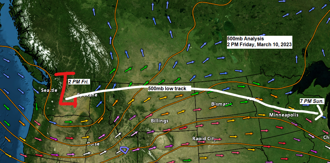
Mid/upper-level low over Washington this afternoon will move ENE into the northern Plains on Saturday, and then will see this upper low dig SE through central Minnesota and central Wisconsin on Sunday.

Here’s a look at this system on vapor imagery over the Pacific northwest today.
Water vapor loop from Friday, March 10, 2023 (loop time ends 5:26 PM CT)

DRY SLOT POTENTIAL
There are differences between the computer models on where the low will be located Sunday morning with the Euro model continuing to favor a farther south low placement which would keep any dry slot confined to far southern portions of the Northland (south of Duluth) late Saturday night/Sunday morning.

On the other hand, you have the NAM guidance which continues to favor a more northerly placement of the low which would increase the chances for a dry slot to push farther north into parts of the Northland (as far north as Duluth) late Saturday night-Sunday.
For those areas impacted by this dry slot, expect snow to end for a few hours, and this dry slot could ultimately lead to lower snow totals than what is in the forecast.

Snowfall Reports for March 9-10, 2023
Source: National Weather Service Duluth, Minnesota
2 N Moquah, WI: 6.1″
2 WSW Washburn, WI: 5.8″
4 NNE Sarona, WI: 3.9″
3 SW Lester Park, MN: 3.2″
7 SSE Earl, WI: 3.0″
3 SW Ashland, WI: 3.0″
3 ENE Holyoke, MN: 3.0″
1 W Solon Springs, WI: 2.8″
2 WSW Superior, WI: 2.7″
2 ESE Duluth, MN: 2.6″
4 NW Casino, MN: 2.5″
7 E Patzau, WI: 2.5″
1 SSW Grantsburg, WI: 2.5″
1 WSW Maple, WI: 2.5″
3 N Amnicon Falls State Park, WI: 2.3″
2 E Esko, MN: 2.2″
1 SSW Pine City, MN: 2.2″
2 NNE Duluth, MN: 2.0″
6 NE Hertel, WI: 2.0″
2 N Pillager, MN: 1.7″
4 WNW Kerrick, MN: 1.6″
3 ENE Wright, MN: 1.2″
5 SSE Libby, MN: 1.1″
1 S Moose Lake, MN: 1.1″
1 ESE Nisswa, MN: 1.0″
1 N Cloquet, MN: 1.0″
1 SW Brainerd, MN: 1.0″
Duluth, MN: 0.9″ (Official total at the NWS in Duluth)
Thanks for reading!
Tim
Leave a Reply