10:52 AM Sunday, March 12, 2023
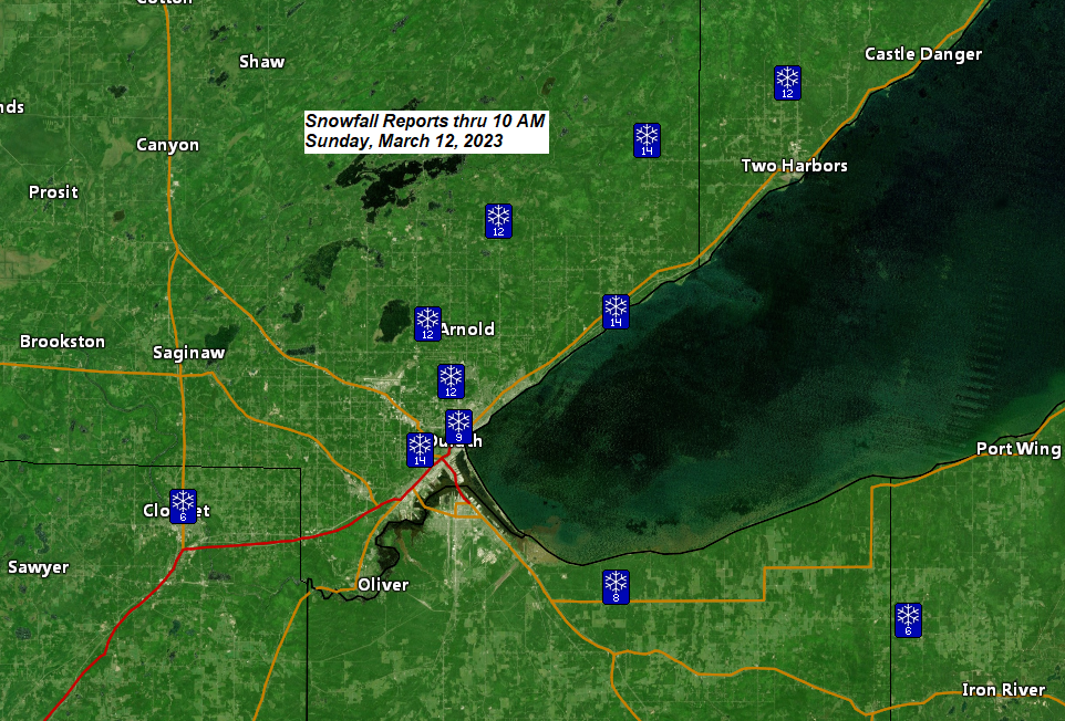
Snowfall Reports through 10 AM Sunday, March 12, 2023
Source: National Weather Service Duluth, Minnesota
2 WNW Duluth, MN: 16.5″
4 WNW Two Harbors, MN: 15.0″
8 NNW Knife River, MN: 15.0″
6 WNW Castle Danger, MN: 14.5″
Hackensack, MN: 14.0″
French River, MN: 14.0″
2 W Duluth, MN: 14.0″
5 S McGregor, MN: 13.5″
7 NNE Rice Lake, MN: 13.3″
1 WSW Lester Park, MN: 13.0″
4 S Rice Lake, MN: 12.5″
5 N Two Harbors, MN: 12.0″
2 NNW Gary New Duluth, MN: 12.0″
2 E Palisade, MN: 12.0″
Hinckley, MN: 12.0″
2 W Fond du Lac, MN: 12.0″
Moose Lake, MN: 11.0″
3 SW Lester Park, MN: 10.8″
7 SSW Grand Rapids, MN: 10.5″
1 SSW Superior, WI: 10.5″
6 SSW South Range, WI: 10.5″
1 SSW Duluth, MN: 10.0″
Grantsburg, WI: 10.0″
1 NE Duluth, MN: 9.9″
McGregor, MN: 9.5″
4 WNW Kerrick MN: 9.2″
1 ENE West Duluth, MN: 9.0″
Askov, MN: 9.0″
3 NNW Brainerd, MN: 9.0″
3 N Amnicon Falls State Park, WI: 8.8″
7 ESE Brainerd, MN: 8.5″
5 NE Hackensack, MN: 8.3″
Kettle River, MN: 8.0″
Deerwood, MN: 8.0″
5 WSW Washburn, WI: 7.5″
Silver Bay, MN: 7.5″
5 SE Aitkin, MN: 7.5″
5 S La Prairie, MN: 7.0″
Minong, WI: 7.0″
5 W Pine Center, MN: 6.5″
1 NNW Washburn, WI: 6.5″
Scanlon, MN: 6.5″
1 NE Hibbing, MN: 6.5″
1 N Cloquet, MN: 6.5″
Oulu, WI: 6.0″
Hayward, WI: 5.8″
Butternut, WI: 5.0″
Ranier, MN: 4.5″
6 SSW Tower, MN: 3.6″
Snow will continue in northeast Minnesota and northwest Wisconsin through this afternoon, but the snow will finally come to an end from northwest to southeast this evening/overnight.
Duluth: Snow through this afternoon and early evening. Snow ends mid to late evening (between 9 PM and 11 PM) Additional snowfall accumulations of 2 to 4 inches are expected in the Twin Ports through early this evening.
HRRR model radar forecast through Midnight tonight.

Strong northeast to north winds with gusts of 25 to 45 mph will continue in Duluth and near Lake Superior through this evening. Areas of blowing and drifting snow will persist due to these gusty winds.
HRRR model wind gust forecast through Midnight tonight.

Mid/upper-level low over central Minnesota this morning will continue to move slowly off to the south/east through this evening.

Here’s a look at the ongoing winter storm impacting the Northland via Goes-16 infrared satellite loop ending 9:51 AM CT, Sunday, March 12, 2023.

Thanks for reading!
Tim
Leave a Reply