6:06 PM Monday, March 13, 2023
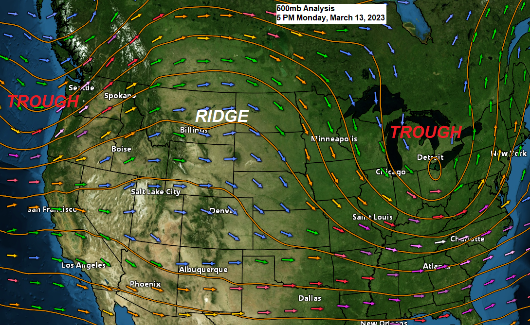
Upper-level ridge moving east out of the Rockies will keep the weather on the quiet side in the Northland through Wednesday, but some changes are possible later this week.
Looks like we’re dealing with a bit of a complex setup for mid to late week with a split flow type of pattern, and because of this it’s not a slam dunk that will be getting a lot of snow in the Northland late this week as there definitely are some red flags showing up in the computer models that could easily turn this into more of a light snow event for most of the Northland, but if things do come together then we could be looking at another significant winter storm for some parts of the Northland.
One notable trend seen in model guidance today in regard to the system late this week is that this system looks like a quick mover unlike some of the previous model runs which showed the low basically stalling out somewhere over Wisconsin, but now we’re seeing a quicker moving low which moves from north-central Kansas to around Chicago or slightly north of Chicago between Thursday morning and Friday morning.
The fact that we have some additional energy in the form of a 500mb low/trough digging S/SE out of Manitoba later this week is probably giving the computer models some difficulties in trying to figure out how this system will evolve later this week, so some more changes are possible in the computer models over the next few days. Stay tuned.
It looks like will see some snow or a mix of rain and snow develop in the Northland Wednesday night into Thursday with a transition to all snow Thursday night. The mixed precipitation chances look highest in eastern Minnesota and northwest Wisconsin on Thursday with a lower chance for mixed precipitation across northern Minnesota.

Note: Looking closer at the 50 member Euro ensemble model shows 25/50 (50%) members forecasting 6″ or more of snow in Duluth, while 10/50 (20%) members forecast 10″ or more of snow. The snowfall minimum in the EPS model is 0.9″ with a high-end amount of 17″.
The highest probabilities for snow amounts which could exceed 6 inches continues to favor northwest Wisconsin with a lower chance in northern Minnesota, while the North Shore, Twin Ports and eastern Minnesota remain in that middle zone between the highest and lowest chances for snow accumulations of 6″+ later this week.

What was the following summer like in Duluth after a top 10 snowiest winter?
9 out of the 10 summers were cooler than average in Duluth with only 1 summer being warmer than average and that occurred in 2013.
Temperature Anomalies for the summers that followed a top 10 snowiest winter in Duluth.
1996: -1.9 degrees
1950: -5.0 degrees
2014: -0.7 degrees
2013: +1.6 degrees
1997: -2.3 degrees
1969: -2.4 degrees
1989: -0.6 degrees
1971: -2.6 degrees
1965: -4.2 degrees
1994: -1.4 degrees
Note: The last cooler than average summer in Duluth was in 2017 so it’s been a few years, and the winter of 2017 had a peak of 20% ice coverage on Lake Superior which is similar to what we saw this winter.
As for rainfall during the summer following a top 10 snowiest winter in Duluth, well rainfall was below average in 8 out of the 10 summers.
Rainfall Anomalies for the summers that followed a top 10 snowiest winter in Duluth.
1996: +4.35″
1950: -1.29″
2014: +0.48″
2013: -3.79″
1997: -1.28″
1969: -4.65″
1989: -2.12″
1971: -0.38″
1965: -0.20″
1994: -1.85″
There are several factors that go into how warm or cool, wet or dry a summer will be, so will see how things play out this upcoming summer.
Ice coverage could be one of those determining factors, and well this winter has had minimal ice coverage on Lake Superior, peaking at 20% back in February, and now the ice coverage has shrunk to around 5% as of March 12th.
Ice data for Lake Superior only dates back to 1973, so there are a few years that would be missing from the above list, but 5 of the top 10 snowiest winters on record in Duluth all had ice coverage peaking at around 80% to 100% and all those years had a cooler than average summer. Meanwhile 2013 which was a warmer than average summer in Duluth had a peak of around 40% ice coverage on Lake Superior.

2023 Ice Coverage in red.

Widespread lake effect clouds were moving south across Lake Superior this morning per Goes-16 Day-Cloud Phase satellite loop from Monday, March 13, 2023 (loop time ends 11:51 AM CT) The dark areas on Lake Superior represents clear skies, while green is ice/snow cover.

Average temperatures so far this month in the Northland are running slightly warmer than average by around 1 degree.

Subzero temperatures in parts of the Northland Monday morning
Note: Normal lows at this time of year are in the teens above zero, but record lows are still well below zero, so getting subzero temperatures in mid-March certainly isn’t unheard of at all.
Embarrass, MN: -9
International Falls, MN: -9
Bigfork, MN: -6
Cass Lake, MN: -5
Cook, MN: -4
Floodwood, MN: -3
Orr, MN: -2
We’re looking at another cold night in the Northland with lows in the single digits and teens below zero away from Lake Superior.
Perhaps a record cold or near record night ahead at Hibbing? Record low temperature for March 14th is -11 set in 1949.

Tim
Leave a Reply