6:12 PM Tuesday, March 14, 2023
A complex setup ahead as we’re dealing with separate pieces of energy, one approaching from the NW while the other moves ENE out of the central Plains. There likely will be at least some phasing that occurs between these two features, and once that phasing occurs will see an area of low pressure deepen quite a bit over the southern/eastern Great Lakes region from Thursday night into Friday. The track of this low hasn’t changed much over the past few days with the low tracking from central Kansas to around the Chicago area or a little north of Chicago between Thursday morning and Friday morning. The uncertainty appears to be coming from how soon the phasing can occur and perhaps the speed of which the trough approaches from the NW. An earlier phase and arrival time of the trough could allow heavy snow to impact more of the Northland, while a later phase would probably cause the main area of snow to be confined to northern Wisconsin and perhaps the Arrowhead of Minnesota. Computer models are wavering back and forth between a farther west or east solution in regard to where the main band of snow sets up late Thursday into Friday, and due to the complex nature of this setup we could very well see a few more changes in the computer models over the next 24 hours.
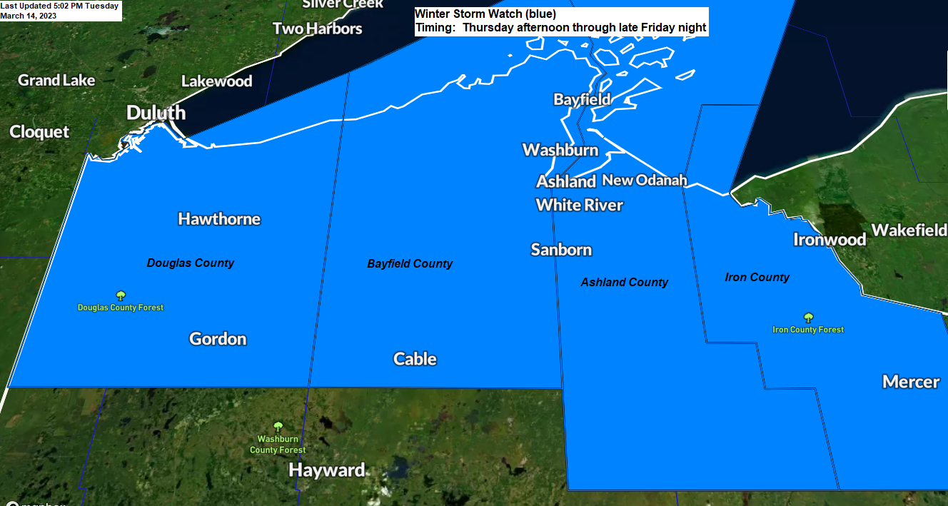
For now, a Winter Storm Watch has been issued for northwest Wisconsin (South Shore area) from Thursday afternoon through late Friday night, but additional winter weather headlines could be issued over the next 24 hours for areas farther to the west and south in the Northland. Some cities in the winter storm watch include Poplar, Brule, Solon Springs, Gordon, Iron River, Port Wing, Cornucopia, Bayfield, Washburn, Cable, Ashland, Mellen, Glidden, Butternut, Hurley and Gile.
Here’s a look at the 500mb forecast valid from 7 AM Thursday to 7 PM Saturday per EPS model forecast.
Note — The greens and blues indicate a strengthening mid/upper level system.

First system Wednesday night-early Thursday morning targets northern Minnesota into the Arrowhead. Here’s my snowfall forecast for this first system.
Note — A light wintry mix including rain and patchy freezing rain is also possible Wednesday night into Thursday morning.

NAM 3km model radar forecast valid 7 PM Wednesday to 7 AM Thursday.
Snow (blue)
Rain (green)
Wintry mix (pink)

Here’s my preliminary snowfall forecast for Thursday afternoon through Saturday morning. Overall, this is a low confidence forecast and some changes (possibly big changes) are definitely possible over the next 24 hours.
A very cold air mass on the back side of this system along with northerly winds crossing a wide-open Lake Superior should cause heavy lake effect/enhanced snowfall along the South Shore of Lake Superior in northwest Wisconsin from Friday into Saturday morning. Note — 850mb temperatures are forecast to fall to around -14 to -20C Friday which is very cold for this time of year, this much cold air moving over the lake should help crank out some heavy lake effect snow along the South Shore late this week.

A lot of water in the snowpack in the Twin Ports and near Lake Superior.
Generally, 6 to as much as 10 inches of water in the snowpack with lower amounts along the immediate shoreline near Lake Superior.
With this much water in the snowpack this does increase the risk for some flooding this spring.

Here’s a larger view of how much water is in the snowpack across the Northland.


Low Temperature Reports from Tuesday morning, March 14, 2023
Source: National Weather Service Duluth, Minnesota
Brimson, MN: -17
Butternut, WI: -16
Embarrass, MN: -15
4 W Clam Lake, WI: -14
Hibbing, MN: -14
Ely, MN: -13
Cotton, MN: -13
3 E Wright, MN: -12
Floodwood, MN: -12
Hayward, WI: -11
Eveleth, MN: -11
Longville, MN: -11
Aitkin, MN: -11
Solon Springs, WI: -11
2 E Celina, MN: -11
Hurley, WI: -11
Ashland, WI: -9
Hinckley, MN: -9
McGregor, MN: -9
Siren, WI: -9
Brainerd, MN: -9
International Falls, MN: -8
Two Harbors, MN: -8
Grand Marais Airport: -8
Cook, MN: -8
Spooner, WI: -7
Orr, MN: -6
Bigfork, MN: -6
Grand Rapids, MN: -6
Pine River, MN: -6
Moose Lake, MN: -6
Cass Lake, MN: -5
Superior Airport: -4
Duluth Airport: -3
*Today’s low of -3 marked the 2nd time this month with a subzero temperature in Duluth. Average number of subzero nights in Duluth during the month of March is 3.
*50 subzero nights last winter in Duluth compared to 28 subzero nights so far this winter (thru March 14th)
*Average date for the last subzero temperature in Duluth is March 9th (1991-2020 climate period) The latest last subzero temperature on record in Duluth was on April 4th set in 1995.
*Hibbing, Minnesota set a new record low temperature this morning of -14 degrees. The previous record low temperature for March 14th was -11 degrees set in 1949. Congrats, Hibbing!
Tim
Leave a Reply