6:31 PM Sunday, March 26, 2023
The wait continues!
The last time Duluth had a temperature of at least 50 degrees was on November 26, 2022. The average date for the first 50-degree temperature in Duluth is March 15 (1991-2020 climate period) And the latest first 50-degree temperature on record at Duluth occurred on May 1 set in 1917.
The chance that Duluth gets a 50-degree temperature for the rest of March 2023 is slim to none, and going back to 2000, there’s only been 4 years where the first 50-degree temperature occurred after April 1. See below…
2001: April 13
2002: April 7
2008: April 3
2018: April 19
Interesting to note, that in 1996, the year that holds the seasonal snowfall record at Duluth, well that year saw the first 50-degree temperature occur earlier than this year, with the first 50 in 1996 occurring on March 13.
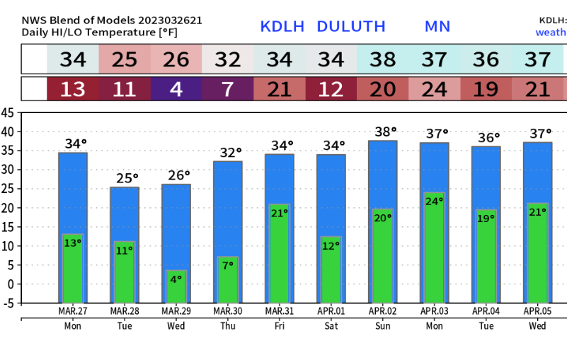
March 2023 is running about -2 to -5 degrees colder than average across the Northland, with Duluth’s temperature anomaly for March 2023 sitting at -2.8 degrees below average as of the 25th.
Only two days this month with a temperature of 40 or warmer in Duluth which is probably the reason why it feels pretty warm on those days where the temperature climbed to at least 40-degrees, just not use to that kind of warmth yet.
Note — There’s been at least 1″ of snow on the ground at the Duluth Airport for 132 consecutive days (and counting) or since November 15th, 2022, and there’s a high likelihood that there will be at least 1″ of snow on the ground for the rest of this month, which would get us to 137 consecutive days with a 1″ or greater snow depth in Duluth by the end of this month.
1 to 2 foot plus snow depths in northeast Minnesota and northwest Wisconsin including a 32-inch snow depth at the Duluth Airport as of 4 PM Sunday, March 26, 2023, but if you go far enough south there is no snow currently on the ground in southeast Minnesota and southwest Wisconsin.

8 to as much as 12 inches of water in the snowpack near Lake Superior with lesser amounts near the immediate shoreline (4 to 6 inches of water)
The good news is it doesn’t look like will be adding a lot of snow or water to the existing snowpack across the Northland this week, but we probably won’t be melting much snow either given the forecasted temperatures the next few days.

Another snow event well south of the Northland last night into this morning with reports of up to 10 inches of snow in far southwest Nebraska, and anywhere from 3 to 7 inches of snow reported in parts of eastern Nebraska into north central Iowa, or from around the Omaha area to locations north of Des Moines.
So that’s two snow events that missed Duluth over the last 2 days, keep that in mind as Duluth still needs 10.1 inches of snow to break the seasonal snowfall record of 135.4 inches.

A few flurries or snow showers are possible at times in parts of the Northland Monday night and Tuesday, but very little accumulation is expected.
The next best chance for an inch or so of snow comes later this week in the Thursday-Friday morning time frame, but there are no strong indications of any major snow event hitting the Northland at least through next weekend.

Tornado watches stretch from far east Texas to central Alabama this evening.

Severe Thunderstorms possible late this week
Risk for severe thunderstorms stretches from central/eastern Kansas to west central Texas on Thursday.

Then on Friday the risk for severe thunderstorms shifts farther to the east.

Tim
Leave a Reply