6:08 PM Friday, April 7, 2023
A new record low temperature was set at Hibbing, Minnesota Friday morning with a low of -2 degrees. The previous record low temperature for April 7 was 0 set in 1982.
It’ll be another chilly night tonight especially in northern Minnesota where temperatures will drop into the single digits and teens above zero while the rest of the Northland see slightly milder temperatures tonight compared to last night.
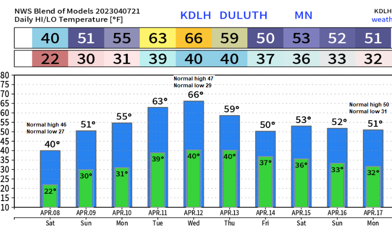
Saturday will feature east winds and cool temperatures (30s) near Lake Superior while temperatures warm into the 40s to around 50 degrees across the rest of the Northland.
A weak system moving into the upper Midwest could produce a few rain showers on Sunday, but widespread heavy rainfall is unlikely with this system. Highs on Sunday in the Northland will range from the mid 40s to mid 50s.
The big melt of 2023 begins next week with several days with highs in the 50s and 60s in the Northland with even some 70s possible in eastern Minnesota and northwest Wisconsin around the middle of next week, and with temperatures at night remaining above freezing on several nights, this means will see nonstop snow melt occur both day and night.
Low Temperature Reports from Friday morning, April 7, 2023
Source: National Weather Service Duluth, Minnesota
2 S Tower, MN: -5
Orr, MN: -4
Crane Lake, MN: -4
Embarrass, MN: -4
International Falls, MN: -3
Hibbing, MN: -2
Grand Marais Airport: -2
Eveleth, MN: 0
Bigfork, MN: 1
Longville, MN: 3
Walker, MN: 4
Grand Rapids, MN: 4
Butternut, WI: 6
Aitkin, MN: 7
Ashland, WI: 8
Brainerd, MN: 8
Duluth Airport: 8
Hayward, WI: 8
Superior Airport: 9
Snow Depths across the Northland as of 7 AM Friday, April 7, 2023
Source: National Weather Service Duluth, Minnesota
Wolf Ridge, MN: 43″
9.8 W Ashland, WI: 32″
3.6 WNW Two Harbors, MN: 30″
Duluth Airport: 29″
Embarrass, MN: 27″
4.4 W Grand Marais, MN: 26″
4.9 NNE Tofte, MN: 26″
1.2 W Solon Springs, WI: 26″
9.2 NNE Hayward, WI: 25″
International Falls, MN: 25″
Ely, MN: 25″
6.1 N Grand Rapids, MN: 25″
4 W Clam Lake, WI: 23″
13.4 N Bovey, MN: 22″
Cotton, MN: 21″
3 S Ashland, WI: 21″
Floodwood, MN: 20″
3 E Orr, MN: 19″
Cook, MN: 18″
2 S Tower, MN: 17″
Hurley, WI: 17″
Two Harbors, MN: 9″
A few rain showers are possible across the Northland on Sunday, but an all-day or widespread rain event is unlikely with this system.
NAM 3km model radar forecast valid 7 AM Sunday to 7 PM Sunday.

Rainfall totals ranging from a trace to around 0.15″ are possible in parts of northeast and east central Minnesota into parts of northwest Wisconsin Sunday.

Probability for temperatures of 70 degrees or higher for next Tuesday-Friday, April 11-14, 2023.
Southern half of Minnesota into central/southern Wisconsin have the highest probabilities (orange and red colors on the loop below) for temperatures in the 70s next week, but there is still a pretty good chance that southern portions of the Northland (Hinckley to Hayward Lakes area) reach 70 degrees or possibly into the 70s next week.

Tim
Leave a Reply