6:52 PM Friday, April 14, 2023
*Occasional rain tonight and Saturday with scattered heavy downpours and isolated thunderstorms possible.
*Another round of precipitation is expected late Saturday night into Sunday, and this precipitation will begin as rain but likely end as snow as colder air moves into the area.
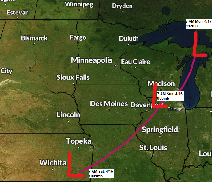
*There is a potential for heavy snowfall accumulations (4″+) mainly in parts of northwest Wisconsin and over far northeast Minnesota from late Sunday afternoon through Monday morning as low pressure deepens as it lifts northeast out of southern Wisconsin late this weekend.
*Gusty north/northwest winds are also expected Sunday into Monday with wind gusts of 25 to 45 mph across the Northland.
*Colder temperatures late this weekend into early next week with overnight temps in the teens and 20s in the Northland, with daytime highs mainly in the 30s on Sunday.
As I mentioned yesterday, the setup for this weekend into early next week is pretty complex and there certainly is bust potential in that this system tracks farther south/east keeping most of the snow/rain on Sunday-Monday mainly east of the Northland, but with the 500mb trough forecast to become negatively tilted this does open up the possibility that will see moisture advect NW into parts of the Northland late this weekend.

Here’s the evolution of the 500mb trough (outlined in black on the image above) from Saturday evening through Monday evening via European computer model.

Rain at times tonight and Saturday.
NAM 3km model radar forecast through 7 PM Saturday.

NWS Blend of Models Total Precipitation thru 7 AM Monday — Highest amounts favoring the Arrowhead and North Shore into far eastern Minnesota into all of northwest Wisconsin with precipitation totals of 1″+ possible.

5-Day Significant River Flood Outlook valid thru April 19, 2023.
Red: Significant River Flooding Occurring
Orange: Significant River Flooding Likely
Yellow: Significant River Flooding Possible

ACCUMULATING SNOW POSSIBLE SUNDAY-MONDAY
The second part of this storm and the more uncertain part of the forecast occurs Sunday and Monday, this is when we see the trough become negatively tilted while a deepening surface low lifts northeast out of southern Wisconsin — Depending on how this system evolves and tracks will determine just how much snow the Northland will see late this weekend.
Here’s the European model radar forecast valid 7 PM Saturday to 7 PM Monday.
Rain (green)
Snow (blue)
Wintry Mix (orange and pink)

Here’s my preliminary snowfall forecast for Sunday-Monday.
At the moment it looks like parts of northwest Wisconsin and far northeast Minnesota stand the best chance for snow totals of 4 inches or more, with most of this snow falling Sunday afternoon/evening into Monday.
Duluth: 1 to 2 inches of snow is possible mainly during the day Sunday.
Snow will likely melt on contact at least for a few hours on Sunday but eventually the ground should cool allowing snow to start accumulating, how long this process takes is uncertain but with how warm it’s been this week and with rain falling first, it will likely take at least a few hours if not longer before snow begins to stick to the roads.

The pattern next week could remain active across the upper Midwest and western Great Lakes with a persistent trough setting up over the Pacific northwest which could send a few systems our way.

This is reflected in the precipitation forecasts from the ensemble models which continue to show significant amounts of precipitation across the area over about the next two weeks with a chance for widespread 1-3″+ precipitation totals in northeast Minnesota and northwest Wisconsin.


Colder trends also continue for next week with well below average temperatures forecast in northeast Minnesota and northwest Wisconsin (black outlined area on map)

Tim
Leave a Reply