6:58 PM Thursday, April 13, 2023
One good thing this week so far has been the lack of precipitation to go along with the very warm temperatures and rapid snowmelt in the Northland, but things could be changing going forward.
A complex setup ahead the next few days, although the overall setup through Saturday morning is pretty straight forward and includes a warm front lifting northward out of central Minnesota while a cold front moves east across the Northland Friday afternoon through Saturday morning. Occasional rain showers and isolated thunderstorms are likely with this system first in north central Minnesota on Friday, then spreading farther east into eastern Minnesota and northwest Wisconsin Friday night into Saturday. Some locally heavy rainfall is possible with PWAT values exceeding an inch Friday night-Saturday morning.
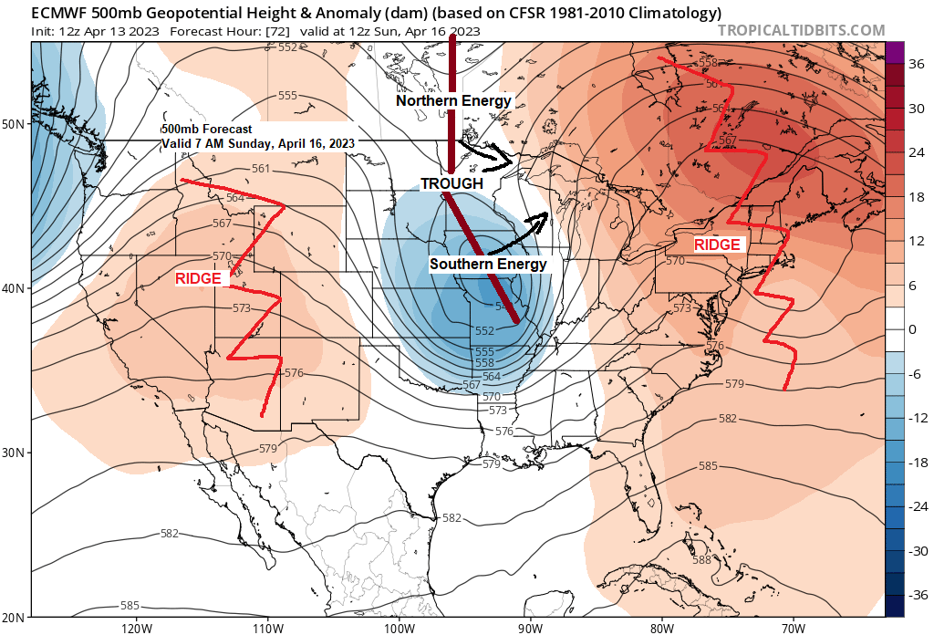
The setup after Saturday becomes much more chaotic as a trough stretches from central Canada to the Midwest while different pieces of energy (one to the north, one to the south) try to phase at some point between Sunday and Monday. Some parts of the Northland could see additional precipitation either rain or snow Saturday night through Monday morning depending on how this system sets up and tracks late this weekend, but there is at least some potential for some snow accumulations in parts of the Northland Sunday-early Monday. Stay tuned.
Rain chances remain highest in northern Minnesota through Friday afternoon, and then rain chances increase farther to the south/east including in Duluth Friday night into Saturday.
NAM 3km model radar forecast valid 7 AM Friday to 7 PM Saturday.

Here’s a look at forecasted precipitation totals thru 7 AM Monday.
Around a quarter to half inch of QPF in far NW areas around International Falls, increasing to 0.50-1″+ for east central and northeast Minnesota into all of northwest Wisconsin.

Some parts of the Northland have a chance of getting more than 3″ of snow late this weekend. At the moment these chances look greatest north/east of Duluth.

NWS Blend of Models total snowfall thru 7 AM Monday.

A more active pattern ahead?
Ensemble models seem to think so as they are showing quite a bit of precipitation across the area over about the next two weeks with a chance for widespread 1-2″+ precipitation totals with >3″ of precipitation possible in parts of northwest Wisconsin per GEFS model.


FLOOD UPDATE
Source: National Weather Service Duluth, Minnesota
Key Messages
-Rapid snowmelt runoff continues
-Elevated water levels in Northland rivers and creeks are being observed and producing flooding
-Flooding of low-lying areas and locations with poor drainage is also occurring.
Pretty much the entire Northland is under some sort of flood headline whether it be a flood advisory or a flood warning.


As of 4:38 PM Thursday, April 13, 2023 — 14 gauges across the area were in Minor Flood Stage (orange), 1 gauge in Moderate Flood Stage (red), and 17 gauges Near Flood Stage (yellow)

Flood Warning for snowmelt in effect until 3:45 PM Saturday for the Moose Horn River and Kettle River affecting portions of Carlton, Aitkin and Pine County in east central Minnesota.
At 12:19 PM, emergency management reported flooding in low-lying areas of the city of Moose Lake and Barnum City Park.
Flooding is occurring along the Moose Horn River and Kettle River.
Some locations that will experience flooding include, Cloquet, Moose Lake, Barnum, Mahtowa, Willow River, Cromwell, Rutledge, Kettle River, Fond Du Lac Band Cloquet Area, Fond Du Lac Band Sawyer Area, Big Lake, Sturgeon Lake, Automba, Denham, Kettle Lake, Moose Lake State Park, Ronald and Sawyer.

Nemadji River near Superior affecting a portion of Douglas County in northwest Wisconsin– Flood Warning for snowmelt now in effect until 5 PM Monday.
Stage was 24.9 feet at 2 PM Thursday. Flood stage is 23.5 feet. The river is expected to continue to slowly rise as snow melt runoff makes its way into the river.
At the gage located at County Highway C, the river may approach a level of 25.5 feet today and remain near this level through the weekend.
At a level of 23.5 feet, the water level is near the bottom of the County Highway C Bridge.
At a level of 26 feet, water encroaches a house west of the Nemadji River on County Road C.

St. Louis River at Scanlon — Flood Warning in effect through Wednesday afternoon.
Moderate flooding is forecast.
Stage at 3:30 PM Thursday was 10.1 feet. Flood stage is 10.5 feet.
The river is expected to rise above flood stage late this afternoon to a crest of 12.5 feet Saturday evening. It will then fall below flood stage early Wednesday morning.
This crest compares to a previous crest of 12.5 feet on July 10, 1999.

Here’s a list of the other flood warnings which are in effect across the Northland.
*Tyler Forks River near Mellen, WI.
*Bad River near Odanah, WI.
*Bad River at Odanah, WI.
*St. Croix River near Danbury, WI.
*Mississippi River at Fort Ripley and Aitkin, MN.
*Snake River at Pine City, MN.
In addition to all of that, there is now a Flood Advisory for snowmelt in effect until 4 PM Monday including portions of north central and northeast Minnesota. Minor flooding in low-lying and poor drainage areas. Overflowing poor drainage areas. Ponding of water in urban or other areas is occurring or is imminent.
Water was leading to washouts along forest roads in the Tofte and Gunflint Ranger districts as of Thursday afternoon.
Some locations that will experience flooding include, Hibbing, International Falls, Ely, Grand Marais, Lake Vermilion, Gunflint Lake, Virginia, Chisholm, Two Harbors, Eveleth, Mountain Iron, Hoyt Lakes, Silver Bay, Gilbert, Aurora, Babbitt, Keewatin, Buhl, Nashwauk and Biwabik.
Flooding issues outlined in black on the map.
Fire weather concerns outlined in blue on the map.
And finally, winter weather outlined in brown on the map.

80s as far north as Hinckley, Siren and Hayward this afternoon with near 90 degree temps in southern Minnesota.
New record high temperatures were set today at Minneapolis, St. Cloud, Eau Claire, Rochester and La Crosse just to name a few.

Of course, temperatures were considerably cooler near Lake Superior today thanks to a gusty NE wind, with temperatures this afternoon running about -30 degrees colder compared to the temperatures from Wednesday afternoon.

A strange pattern right now with widespread very warm to hot temperatures stretching from the western High Plains to the upper Midwest into the northeast U.S. while it’s chilly in parts of Mississippi with temperatures only in the 50s today.

Tim
Leave a Reply