6:42 PM Sunday, April 16, 2023
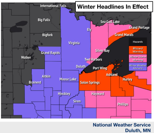
Snow along with strong north winds gusting 30 to 55 mph will produce considerable blowing snow along with blizzard/near blizzard conditions along the South Shore of Lake Superior in northwest Wisconsin, and also in southern Cook County in northeast Minnesota tonight and Monday. Blizzard conditions are most likely along and north of Highway 2 in northwest Wisconsin, east of the city of Superior. Travel will be very difficult to impossible. Travel should be restricted to emergencies only. In addition, gusty winds could bring down trees. Some cities in the blizzard warning include, Tofte, Lutsen, Grand Marais, Hovland, Poplar, Port Wing, Cornucopia, Bayfield, Washburn, Ashland and Hurley.
For Duluth: Heaviest snow is done with this storm, but there will be some lingering light snow and flurries around tonight into Monday morning with additional snowfall accumulations of less than 1″. Season snowfall total is at 135 inches thru 5 PM today. Will need an additional 0.5 inches of snow out of this storm tonight to set a new seasonal snowfall record, otherwise we’re going to have to wait until later this week for the next system which isn’t a lock that it will impact our area, and even if it does there’s no guarantee yet on if it would bring snow to the Twin Ports. Gusty north to northwest winds of 25 to 45 mph tonight and Monday in the Twin Ports.
Snowfall Reports from Sunday, April 16, 2023
Source: National Weather Service Duluth, Minnesota
1 SW Brainerd, MN: 7.0″
Chisholm, MN: 6.7″
Keewatin, MN: 6.5″
Aitkin, MN: 5.5″
Buyck, MN: 5.5″
7 W Hill City, MN: 5.5″
Nisswa, MN: 5.3″
1 WNW Ely, MN: 5.3″
2 N Cloquet, MN: 5.0″
McKinley, MN: 5.0″
3 E Payne, MN: 4.8″
Palisade, MN: 4.5″
Breezy Point, MN: 4.0″
Pillager, MN: 4.0″
Duluth, MN: 3.3″ (Official total at the NWS thru 4 PM Sun.)
1 SSE Oulu, WI: 2.1″
3 N Amnicon Falls State Park, WI: 1.5″
1 SSE Cornucopia, WI: 1.1″
NAM 3km model radar forecast through 11 PM Monday.
Snow continues through Monday evening in far northeast Minnesota and in northwest Wisconsin, especially along the South Shore. This snow will gradually end from west to east in the aforementioned areas Monday afternoon-evening.
Snow across the rest of northeast and east central Minnesota should end later this evening.

Duluth area: Less than 1″ of additional snow tonight so snowfall storm totals will end up right around 3 or 4″.
There hasn’t been much snow yet in far northeast Minnesota or in northwest Wisconsin or in the 8-12″ and 6-8″ zones on the map below but that should change tonight and Monday.

Low pressure centered over northern Lake Michigan late this afternoon will drop a little south tonight before lifting ENE across the half of northern Lower Michigan to Lake Huron by Monday evening.

A deep negatively tilted trough covered the upper Midwest and western Great Lakes this afternoon. This upper trough will lift slowly N/NE through Monday.

This storm is really wrapping up/deepening over the Great Lakes late this afternoon.
Goes-16 water vapor loop ending 5:51 PM CT, Sunday, April 16, 2023.

ONGOING FLOODING
Note — Chambers Grove Park in the Fond du Lac area of Duluth, Minnesota has been closed due to flooding from the St. Louis River per report from Duluth Parks and Rec Sunday afternoon.

5-Day Significant River Flood Outlook through April 21, 2023
Red: Significant River Flooding Occurring
Orange: Significant River Flooding Likely
Yellow: Significant River Flooding Possible

Tim
Leave a Reply