1:09 PM Sunday, April 16, 2023
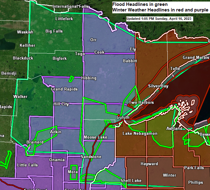
FLOOD UPDATE
Source: National Weather Service Duluth, Minnesota
St. Louis River at Scanlon — Flood Warning remains in effect until further notice.
Major flooding is occurring, and major flooding is forecast.
At 11:30 AM Sunday, the stage was 13.5 feet (major flood stage is 13.0 feet)
The river is expected to rise to a crest of 14.0 feet tomorrow morning. It will remain above flood stage through Saturday. Flood stage is 10.5 feet.
Flood history — This crest compares to a previous crest of 13.9 feet on April 23, 1979.

Flood Warnings for the following rivers
-Prairie River near Taconite affecting Itasca County. Minor flooding is occurring, and minor flooding is forecast.
-Mississippi River at Fort Ripley and Aitkin affecting Crow Wing and Aitkin Counties. Moderate flooding is forecast.
-Snake River near Pine City. Minor flooding is occurring, and minor flooding is forecast.
Flood Warning now in effect until late tomorrow evening for the Tyler Forks River at Stricker Road near Mellen. Minor flooding is occurring, and minor flooding is forecast.
Flood Warning in effect until 4 PM Monday for Aitkin, Carlton, Lake, Pine and St. Louis County in northeast Minnesota. Flooding caused by rain and snowmelt is occurring. Numerous roads remain closed due to flooding. Some locations that will experience flooding include, Cloquet, Hermantown, Two Harbors, Proctor, Sandstone, Moose Lake, Scanlon, Carlton, Mahtowa, Barnum, Floodwood, Willow River, Askov, Cromwell, Rutledge, Kettle River, Thomson, Brookston and Tamarack.
Flood Warning in effect until 4 PM Monday for Ashland and Iron County in northwest Wisconsin. Numerous roads remained closed due to flooding. At 958 AM, trained weather spotters reported flooding in the warned area along the Montreal and Potato River. Some locations that will experience flooding include, Hurley, Saxon, Gurney, Upson, Gile, Montreal, Kimball, Pence, Iron Belt, Cedar, Birch Hill, Gile Flowage, Bad River Reservation.
Flood Warning in effect until 4 PM Monday for Bayfield and Douglas County in northwest Wisconsin. Flooding caused by rain and snowmelt is occurring. Numerous roads remained closed due to flooding. Some locations that will experience flooding include, Superior, Ashland, Washburn, Iron River, Maple, Barksdale, Poplar, Brule, Oulu, Bayfield, Drummond, Port Wing, Ino, Town of Delta, Herbster, Benoit, Cornucopia, Sand Bay and Red Cliff.
ROAD CLOSURE
Source: St. Louis County social media page
-Highway 29 north of Floodwood is closed near Stremmel Road, just east of TH 73 intersection. This is the primary route between Floodwood and Meadowlands. Travelers can use Trunk Highway 73 and Highway 133 as a detour. But use caution, there is water on TH 73, too.
Tim
Leave a Reply