7:01 AM Sunday, April 16, 2023
Winter Storm Warnings are in effect for portions of the Northland including the North Shore and Arrowhead, and for almost all of northwest Wisconsin.
Winter Weather Advisory for other parts of the Northland including Duluth.
Travel will be difficult due to snow and slush covered roads through Monday morning. Occasional whiteout/near whiteout conditions are also possible especially in the winter storm warning area due to falling and blowing snow.
Note — Duluth needs 0.2 inches of snow to move the winter of 2022-2023 into 2nd place for most snow on record, and Duluth needs 3.8 inches of snow to set a new seasonal snowfall record. Will see what happens today.
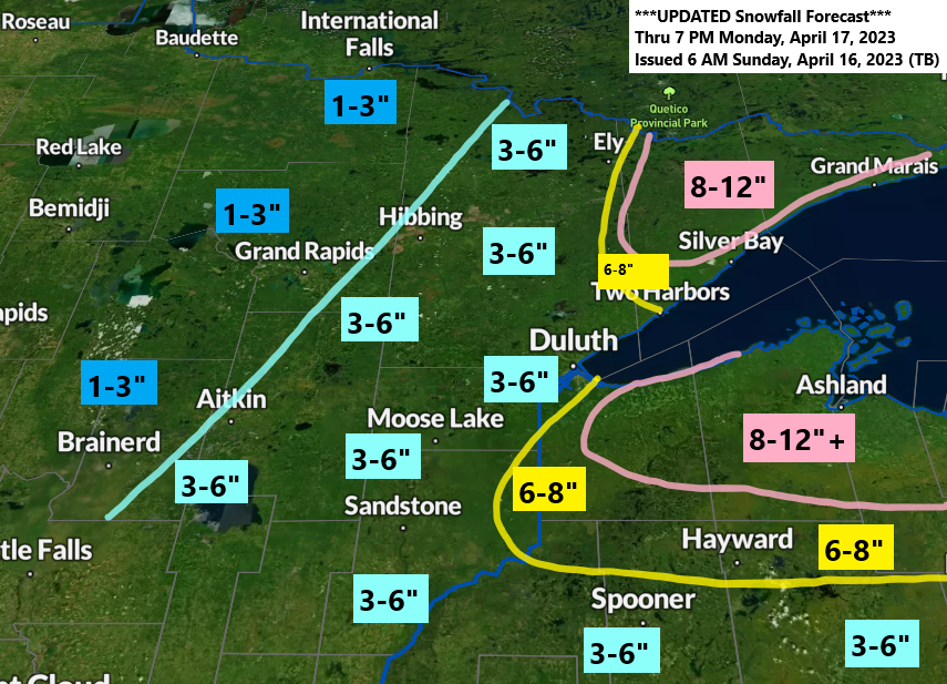
Warmer ground temperatures, mixed precipitation types, and compaction issues will all play a role in how much snow accumulation we see in the Northland, but here is my updated snowfall forecast through 7 PM Monday.
Highest amounts over the Arrowhead and in parts of northwest Wisconsin (South Shore) with 8 to 12 inches of snow expected in those areas with more than 12 inches of snow possible in a few locations especially along the South Shore.
Duluth area: 3 to 6 inches of snow, although I’m leaning toward the lower end of that range, so closer to 3 inches instead of 6 inches.

Widespread snow, rain and a wintry mix moving northwest across the Northland early this morning.

It still looks like the heaviest precipitation rates in Duluth will occur before Noon today, but light snow will continue this afternoon and this evening.
RRFS-A model radar forecast through 7 PM this evening (Sunday)
Snow (blue)
Wintry Mix (orange and purple)
Rain (green)

WINTER WEATHER HEADLINES

Temperatures aloft are cold enough in most of the Northland for precipitation to fall in a frozen form whether that would be snow, sleet or freezing rain this morning, with the exception to this along the North Shore and also over parts of northwest Wisconsin where temperatures aloft remain slightly above 0C at 850mb but that shouldn’t last much longer.

Low pressure near/southwest of Green Bay, WI early this morning won’t be moving very quickly as it takes until late Monday afternoon for this low to reach Lake Huron.

A look at the storm impacting the Northland on satellite imagery.
Goes-16 sandwich satellite loop ending 6:16 AM CT, Sunday, April 16, 2023

Goes-16 water vapor loop ending 6:16 AM Sunday, April 16, 2023.

Tim
Leave a Reply