6:15 PM Friday, April 21, 2023
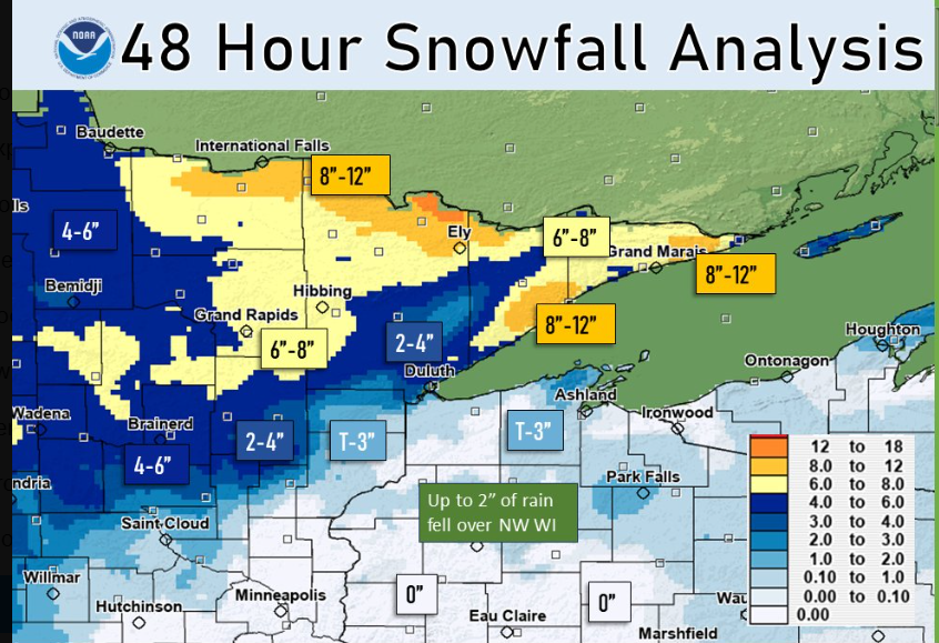
A strong spring/winter storm brought heavy wet snow, heavy rain and isolated thunderstorms to the Northland late Wednesday night into Thursday. This storm also produced very strong northeast winds near Lake Superior with gusts to nearly 60 mph reported in Duluth, while a significant ice storm occurred in higher elevation inland from Lake Superior with freezing rain/ice accumulations reaching one quarter inch or more. Ice accumulating on trees combined with the strong winds caused some tree damage in higher elevation near Lake Superior.
This same storm will linger over the Northland the next few days as a large and slow-moving upper-level low spins across the upper Midwest, Great Lakes and Ontario into early next week, but we’re not looking at any major precipitation associated with this upper low with mainly just some scattered flurries and snow showers tonight and Saturday.
Record or near record low temperatures are possible in the Northland this weekend into early next week as a chilly air mass lingers over the area. The best chance for some record lows to be broken or tied in our area comes Saturday night/Sunday morning, and again Sunday night/Monday morning.
Note: Season snowfall total at Duluth for 2022-2023 is up to 139.5 inches as of 4 PM Friday, April 21, 2023. This is +51.9 inches of snow above normal to date, and is 159% of normal snowfall to date.
Snowfall Reports from the April 20-21 Winter Storm
Source: National Weather Service Duluth, Minnesota
0.1 NE Hovland, MN: 15.0″
0.4 W Silver Bay, MN: 15.0″
2.8 WNW Hovland, MN: 11.2″
9.7 NNE Two Harbors, MN: 10.1″
10.3 E International Falls, MN: 9.3″
11.8 N Lutsen, MN: 8.7″
25 E Ely, MN: 8.7″
1.8 SSW Ely, MN: 8.5″
1 W Buyck, MN: 8.3″
3 E Orr, MN: 8.1″
0.6 WNW International Falls, MN: 8.1″
13.4 N Bovey, MN: 8.0″
7 WSW Pine River, MN: 7.7″
0.7 S Coleraine, MN: 7.5″
3.7 W Deer River, MN: 7.5″
0.9 WNW Ely, MN: 7.3″
6.3 N Grand Rapids, MN: 7.1″
Embarrass, MN: 7.1″
6.5 S Deer River, MN: 7.0″
Chisholm, MN: 7.0″
3.8 NNE Grand Marais, MN: 7.0″
1 SSE Hibbing, MN: 6.5″
Cass Lake, MN: 6.4″
4.2 ENE Nisswa, MN: 6.0″
4.4 W Grand Marais, MN: 5.9″
5.1 N Pillager, MN: 5.5″
8.4 NW Aitkin, MN: 5.5″
5.7 ESE Cotton, MN: 5.3″
Silver Bay, MN: 5.1″
8 NE Cook, MN: 4.9″
1 WNW Brainerd, MN: 4.8″
7 N McGregor, MN: 4.5″
Brainerd, MN: 4.0″
Duluth, MN: 3.8″ (Official total at the NWS)
3.3 W Cloquet, MN: 3.3″
3.4 ENE Cloquet, MN: 3.0″
Two Harbors, MN: 2.6″
Palisade, MN: 2.0″
4.3 W Superior, WI: 2.0″
Wrenshall, MN: 1.8″
9 N Bayfield, WI: 1.5″
0.6 SW Moose Lake, MN: 1.1″
3.7 WNW Superior, WI: 1.0″
0.4 ENE Sturgeon Lake, MN: 1.0″
Record Events on April 20, 2023
Duluth, Minnesota: Daily snowfall record of 3.2 inches tied. This record was set 130 years ago in 1893.
International Falls, Minnesota: New daily snowfall record of 5.9 inches. Previous record snowiest April 20 was 5.0 inches set in 1970. International Falls also set a new daily snowfall record for April 21 with 2.5 inches of snow today. The previous snowiest April 21 was 2.4 inches set in 2012.
Ashland, Wisconsin: New daily precipitation record of 1.72 inches.
Significant amounts of precipitation in the Northland over the last few days with 1 to 2 inches of precipitation in parts of northwest Wisconsin to around an inch in northeast and east central Minnesota.
Precipitation stats for Duluth, Minnesota for 2023
Total since January 1: 8.13″
Normal to date: 5.11″
Anomaly: +3.02″ above normal to date
Percent of normal precipitation to date: 159% of normal

A massive upper-level trough across the region today as seen on Goes-16 water vapor imagery (loop time ends 5:21 PM CT, Friday, April 21, 2023)

Scattered snow showers continue across the Northland tonight and Saturday.
NAM 3km model radar forecast thru 7 PM Saturday.

Cool trends continue for next week with a high likelihood for colder than average temperatures in northeast Minnesota and northwest Wisconsin. Note: Normal highs in Duluth range from the low to mid 50s next week with normal lows in the low to mid 30s.
GEFS model temperature anomaly trend for April 23-28, 2023.
Below Average Temperatures — Blue and Purple
Above Average Temperatures — Orange and Red

Here are the record low temperatures for April 23-24.
Record Low Temperatures for April 23rd
International Falls: 6 set in 1909
Ashland: 11 set in 1893
Duluth: 12 set in 1909
Brainerd: 18 set in 1967
Hibbing: 19 set in 2015
Record Low Temperatures for April 24th
International Falls: 10 set in 1909
Ashland: 15 set in 1936
Brainerd: 15 set in 1956
Hibbing: 16 set in 2013
Duluth: 19 set in 1956
Tim
Leave a Reply