6:19 PM Thursday, April 27, 2023
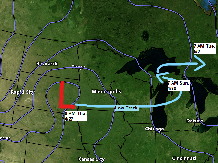
We’re heading back into an unsettled and cool pattern in the Northland through early next week as another large and slow-moving surface and upper level low/trough stalls out over the Great Lakes. This system will bring occasional precipitation to northeast Minnesota and northwest Wisconsin from tonight through early next week with some breaks in the precipitation likely. A lot of this precipitation will fall as rain, but as colder air wraps into this system will likely see the rain change over to wet snow at times this weekend into early next week, with the snow chances highest in far northeast Minnesota and in northern Wisconsin in higher elevation inland from Lake Superior. Significant snowfall accumulations of 3 to 6 inches or more are possible late Saturday through Monday along the South Shore of Lake Superior in northwest Wisconsin (inland from Lake Superior), and also in extreme northeast Minnesota.
Flood Watch in effect through Sunday for all of northwest Wisconsin, and for parts of northeast and east central Minnesota.
Source: National Weather Service Duluth, Minnesota.
*Snowmelt and additional precipitation continue to lead to excess water working through creeks and rivers. Soils are saturated.
*Elevated water levels and additional flooding is possible.
*Second or third crests will be possible on area rivers with incoming precipitation.

Gusty northeast winds are possible near Lake Superior and in Duluth late tonight through about mid-afternoon on Friday with wind gusts of 25 to 35 mph possible. Winds diminish later Friday afternoon.
HRRR model wind gust forecast valid 1 AM Friday to 7 PM Friday.

Today was likely the warmest day will see around here until sometime next week.
High of 54 at the Duluth Airport today. First time since April 18th with a temperature of at least 50, and today’s high of 54 is the warmest temperature since April 14th (high was also 54)
Today, April 27th marked the 8th day this month with a high temperature of at least 50 degrees in Duluth. The average number of days at or above 50 in April is 13 days. Note — Last April saw even fewer days with a temperature of at least 50 in Duluth, with only 1 day reaching that mark.

There are some big differences in the computer models with how far north the heavier precipitation totals will get in the Northland.
The yellow outlined area on all four images represents where precipitation totals of 0.50-1″+ are possible thru 7 AM Saturday.
Note — European model is farthest south with the heavier precipitation as this model keeps it south of Duluth, favoring areas from eastern Minnesota into northern Wisconsin for half inch to an inch or more of precipitation thru 7 AM Saturday, whereas the NWS Blend of Models, HREF model, and the Rapid Refresh (RRFS) Prototype model is farther to the north, so for now the Euro model is the odd model out with its more southerly solution.


Precipitation tonight and Friday should mainly be in the form of rain across the Northland, but there is a chance that we could see some wet snow mix in at times on Friday in northeast Minnesota if we can get enough dynamical cooling to occur.
NAM 3km model radar forecast thru 7 PM Friday.
Rain (green)
Snow (blue)

A look at the precipitation analysis from last night’s clipper system which moved through the Northland.

Precipitation Reports from Wednesday night-Thursday morning, April 26-27, 2023
Source: MesoWest
Two Harbors, MN: 0.38″
Saginaw, MN: 0.33″
French River, MN: 0.33″
Duluth Airport: 0.32″
Hill City, MN: 0.31″
Chisholm-Hibbing Airport: 0.31″
The Bay of Grand Marais, MN: 0.29″
Isabella, MN: 0.26″
Esko, MN: 0.26″
Orr, MN: 0.25″
Longville, MN: 0.23″
Deer River, MN: 0.22″
Moose Lake, MN: 0.21″
International Falls, MN: 0.20″
Bayfield, WI: 0.20″
Poplar, WI: 0.19″
Ely, MN: 0.19″
Cloquet, MN: 0.18″
Pine River, MN: 0.18″
Eveleth-Virginia, MN: 0.18″
Duluth Sky Harbor Airport: 0.15″
Brainerd, MN: 0.15″
Grand Rapids, MN: 0.14″
Superior Airport: 0.13″
Washburn, WI: 0.12″
Walker, MN: 0.11″
Aitkin, MN: 0.10″
Ashland, WI: 0.08″
Siren, WI: 0.03″
Glidden, WI: 0.02″
Hayward, WI: 0.01″
Solon Springs, WI: 0.01″
There was a little bit of snow with last night’s system in extreme northeast Minnesota.

Snowfall Reports from Wednesday night-early Thursday morning, April 26-27, 2023
Source: National Weather Service Duluth, Minnesota
3 SE Finland, MN: 2.0″
3 NW Hovland, MN: 1.6″
4 NNE Grand Marais, MN: 1.5″
1 W Silver Bay, MN: 1.3″
7 NNE Wales, MN: 1.2″
4 W Grand Marais, MN: 1.0″
Tim
Leave a Reply