6:20 PM Monday, May 1, 2023
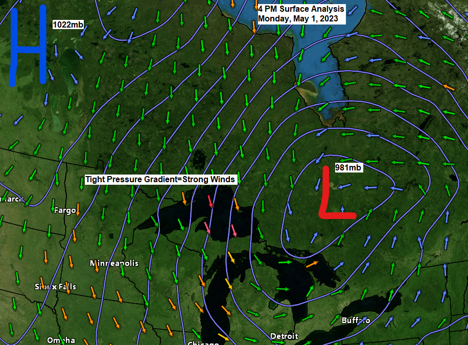
A powerful area of low pressure of 981mb continues to churn just east of the Great Lakes today. Widespread strong winds continued in the Northland today due to a tight pressure gradient between the low off to the east and high pressure to the northwest. Meanwhile wet heavy snow and rain continued to fall in upper Michigan today closer to low.
Gusty winds will continue across the Northland tonight and Tuesday with wind gusts of 40 to 55 mph (strongest along the North Shore)
Highs Tuesday ranging from the 40s in far northeast Minnesota and along the South Shore to the 50s elsewhere. More clouds to the east, more sun to the west Tuesday.
Everything sets up perfectly to give us at least one nice spring day on Wednesday with much lighter winds. Highs Wednesday will range from the mid 50s to mid 60s which is pretty much where we should be in early May. These milder temperatures will then persist for the rest of the week and into this weekend, but an east wind will return so it will be much cooler closer to Lake Superior Thursday through this weekend.
Goes-16 water vapor loop from Monday, May 1, 2023 (loop time ends 4:31 PM CT)

To go along with the strong surface low is an equally strong low in the mid and upper levels of the atmosphere near Lake Huron with 500mb heights down to 523 decameters or 3 to 4 standard deviations below normal for this time of year.

Another 6 to 12 inches or more of wet heavy snow accumulation is expected by Tuesday afternoon from far northeast Wisconsin into much of western/central upper Michigan with the greatest snow amounts favoring higher elevation inland from Lake Superior.

MRMS Precipitation Analysis over the last few days.

Snow (blue)
Rain (green)

WEATHER HEADLINES
-Wind Advisory extended until 1 PM Tuesday for the North Shore, and until 8 AM Tuesday for Duluth. North winds with gusts of 40 mph to as high as 55 mph. Tree limbs could be blown down and a few power outages may result.
-Winter Weather Advisory now in effect until 1 PM Tuesday for Ashland and Iron County in northern Wisconsin with additional wet snow accumulations of 1 to 6 inches.
-Flood Warning for the Tyler Forks River near Mellen, and for the Mississippi River near Fort Ripley and near Aitkin.
-Flooding is also possible on the Bad River.
-Fire headlines across north central and eastern Minnesota with critical fire weather conditions including gusty northwest winds and low relative humidities. The Northland is still waiting for the spring green-up to occur similar to last spring.

Tim
Leave a Reply