10:52 AM Sunday, May 7, 2023
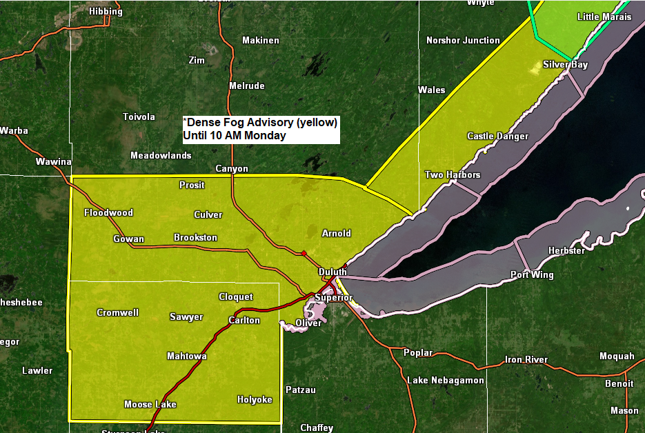
Very little change in the weather is expected near Lake Superior over the next few days with more fog and mist at times with periods of dense fog reducing visibility to a quarter mile or less. Temperatures below the hill in Duluth and for other locations closer to Lake Superior will likely remain in the low to mid 40s today and again on Monday with east winds gusting to around 20 mph. Note — Wind chills (feels like temps) have been as low as the upper 20s and low 30s at times at the Duluth Harbor and Superior over the last few days. There is a chance that the east wind will relax a bit come mid to late week, and if that does happen, then we could see temperatures climb into the 50s close to Lake Superior mid to late week, but I don’t have a lot of confidence that this will actually happen.
A warming trend is more likely to occur farther inland from Lake Superior (on top of the hill in Duluth) with high temps around 60 on Tuesday, then warming into the 60s to around 70 degrees for Wednesday and Thursday.
24-Hour Rainfall Analysis ending 7 AM Sunday, May 7, 2023.

24-Hour Rainfall Reports from May 6-7, 2023, ending 9 AM on the 7th
Source: MesoWest; NWS Duluth, Minnesota
Walker, MN: 1.21″
6 SW Finlayson, MN: 0.93″
Cass Lake, MN: 0.75″
Moose Lake, MN: 0.75″
3 E Wright, MN: 0.62″
5 S Herbster, WI: 0.60″
8.1 W Solon Springs, WI: 0.58″
Deer River, MN: 0.56″
Longville, MN: 0.53″
Duluth Airport: 0.49″
Cloquet, MN: 0.46″
Eveleth-Virginia Airport: 0.43″
Bigfork, MN: 0.42″
Grand Rapids, MN: 0.41″
Pine River, MN: 0.38″
Esko, MN: 0.36″
Shell Lake, WI: 0.31″
Duluth Sky Harbor Airport: 0.30″
Superior Airport: 0.28″
Webb Lake, WI: 0.26″
Poplar, WI: 0.26″
Glidden, WI: 0.25″
Chisholm-Hibbing Airport: 0.24″
Siren, WI: 0.23″
The Bay of Grand Marais, MN: 0.23″
Brainerd, MN: 0.21″
French River, MN: 0.21″
Solon Springs, WI: 0.18″
Clam Lake, WI: 0.18″
McGregor, MN: 0.18″
Hayward, WI: 0.18″
Washburn, WI: 0.14″
Orr, MN: 0.13″
Hinckley, MN: 0.12″
Isabella, MN: 0.10″
Ely, MN: 0.09″
Two Harbors, MN: 0.08″
Littlefork, MN: 0.05″
Ashland, WI: 0.02″
International Falls, MN: 0.01″
Scattered showers will linger in parts of the Northland today into this evening with northern Minnesota having the greatest chance for getting some rain at times through this evening.
HRRR model through 10 PM Sunday evening.

Far southern portions of the Northland (black line on map) from around Brainerd to Hinckley to Minong and Hayward and points south from there should see temperatures warm well into the 60s and possibly even into the lower 70s this afternoon, but it will remain much cooler farther north especially near Lake Superior and in the Twin Ports with temperatures mostly in the 40s this afternoon.

Tim
Leave a Reply