6:21 PM Wednesday, May 10, 2023
Chances for a few showers will continue in the Northland the next few days, but overall, we’re heading into a drier weather pattern locally which could last well into next week the way it looks now.
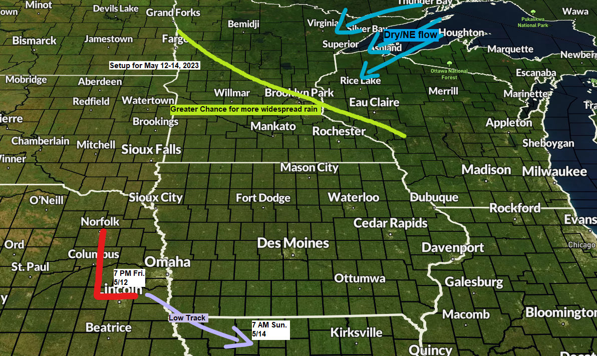
More widespread rain is expected at times from tonight through this weekend in parts of western-southern Minnesota thanks in part to an area of low pressure which lifts northeast out of the southern Rockies, this low is forecast to move into eastern Nebraska on Friday, but will then get pushed southeast into Missouri by Sunday due to an area of high pressure north of Lake Superior, this high should act as a shield to help keep much of this rain from hitting northeast Minnesota and northwest Wisconsin Friday through Sunday.
Goes-16 water vapor loop from Wednesday, May 10, 2023 (loop time ends 5:10 PM CT)

Rainfall forecast through 7 AM Sunday, May 14, 2023.

NAM 3km model radar forecast through 7 PM Thursday.

Warming trend continued today with highs mostly in the 70s in northeast Minnesota and northwest Wisconsin with cooler temperatures closer to Lake Superior as a light onshore wind persists, but this lake cooling isn’t spreading very far inland, and this will likely be the case once again on Thursday, but a stronger NE wind is likely for Friday and Saturday which will lead to much cooler temperatures near Lake Superior while also spreading a good distance inland from Lake Superior as well.
I’ve mentioned recently how similar this spring has been to last spring in Duluth, and just another example of this would be when the first 70 degree temperature of the year occurred in Duluth. This spring the first 70 occurred today, May 10, while last year’s first 70 in Duluth was also on, you guessed it, May 10. Note — The mean date for the first 70 degree temperature in Duluth is April 23.
Prior to today, the last time the temperature was at least 70 degrees in Duluth was on November 2, 2022, so yeah, it’s been a while.

Temperatures were running about +15 degrees warmer than average in much of the Northland this afternoon.

It’s also slightly humid today with dew points in the low to mid 50s in parts of the Northland. Similar dew points are expected again on Thursday.

Southern portions of the Northland saw some rain with pockets of heavier downpours which included a few thunderstorms last evening into early this morning.

Rainfall Reports from Tuesday evening-Wednesday morning, May 9-10, 2023
Source: MesoWeset
Brainerd, MN: 0.91″
Webb Lake, WI: 0.90″
Aitkin, MN: 0.72″
Winter, WI: 0.65″
Cable, WI: 0.52″
Solon Springs, WI: 0.40″
McGregor, MN: 0.36″
Duluth Sky Harbor Airport: 0.34″
Saginaw, MN: 0.34″
Chisholm-Hibbing Airport: 0.34″
Moose Lake, MN: 0.28″
Shell Lake, WI: 0.26″
Eveleth-Virginia, MN: 0.19″
Hayward, WI: 0.19″
Pine River, MN: 0.17″
Poplar, WI: 0.16″
Longville, MN: 0.13″
Spooner, WI: 0.13″
Ashland, WI: 0.12″
Esko, MN: 0.10″
Hill City, MN: 0.07″
Hinckley, MN: 0.07″
French River, MN: 0.07″
Cloquet, MN: 0.06″
Superior Airport: 0.05″
Duluth Airport: 0.04″
Walker, MN: 0.04″
Still looks like will be seeing a very strong ridge develop over western Canada this weekend into next week with a strong trough covering eastern Canada. The Northland will be in a NW flow next week between the ridge to the west and trough to the east, and this pattern looks relatively dry for our area as well.

The warmest temperatures compared to average are forecast to remain over western Canada next week with the coolest temperatures compared to average found over eastern Canada and the northeast U.S.
The Northland will be caught in the middle with a few days of warmer than average temps, but also a few days that feature near to below average temps next week.

Tim
Leave a Reply